Issue Date: Tuesday, August 17th, 2021
Issue Time: 8:40AM MDT
— Flooding is NOT expected today
— An Elevated Flood Threat is expected Wednesday and Thursday mainly over western Colorado
Major changes are underway for Colorado’s weather over the next few days, but today will act as a calm transition period with limited rainfall. As shown in the visible satellite image, below, a weakening upper-level ridge will remain in control of our weather for one more day. Moisture remains lacking with Grand Junction’s morning Precipitable Water (PW) coming in at 0.71 inches, and Denver’s at a paltry 0.53 inches. Just like yesterday, boundary layer moisture remains very limited and has fallen a bit even along the NM border.
With upper-level heights beginning to fall today in advance of the incoming strong trough, signaling a destabilizing atmosphere, isolated to scattered showers and weak storms are expected mainly over the higher terrain of northern and central Colorado. Some isolated showers could also begin to pop up overnight over northwest Colorado. But due to the aforementioned dry boundary layer, flooding is NOT expected today.
The northern half of the state will continue to experience smoky skies throughout the day until steering winds aloft turn more westerly and southerly. Much better air quality is expected beginning tomorrow.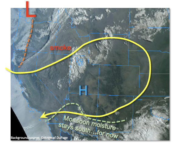
Today’s Flood Threat Map
For more information on today’s flood threat, see the map below. If there is a threat, hover over the threat areas for more details, and click on burn areas to learn more about them. For Zone-Specific forecasts, scroll below the threat map.
Zone-Specific Forecasts:
Grand Valley, Northwest Slope, Central Mountains, Northern Mountains, San Juan Mountains, Southwest Slope, San Luis Valley, Southeast Mountains and Front Range:
Isolated to widely scattered showers and weak storms this afternoon, with the highest coverage over the northern and central higher terrain. Max 1-hour rainfall up to 0.4 inches. Gusty winds will also be possible with the strongest storm. Flooding is NOT expected today.
Primetime:
12PM through 9PM
Palmer Ridge, Urban Corridor, Raton Ridge, Southeast Plains and Northeast Plains:
Mainly dry and continued hot today with an isolated shower or weak storm possible in the foothills. Max 1-hour rainfall up to 0.3 inches, along with possibly gusty winds. Flooding is NOT expected today.
Primetime: 2PM through 9PM