Issue Date: Monday, August 16th, 2021
Issue Time: 9:35AM MDT
— A LOW flood threat has been issued for the Southwest Slope and San Juan Mountains
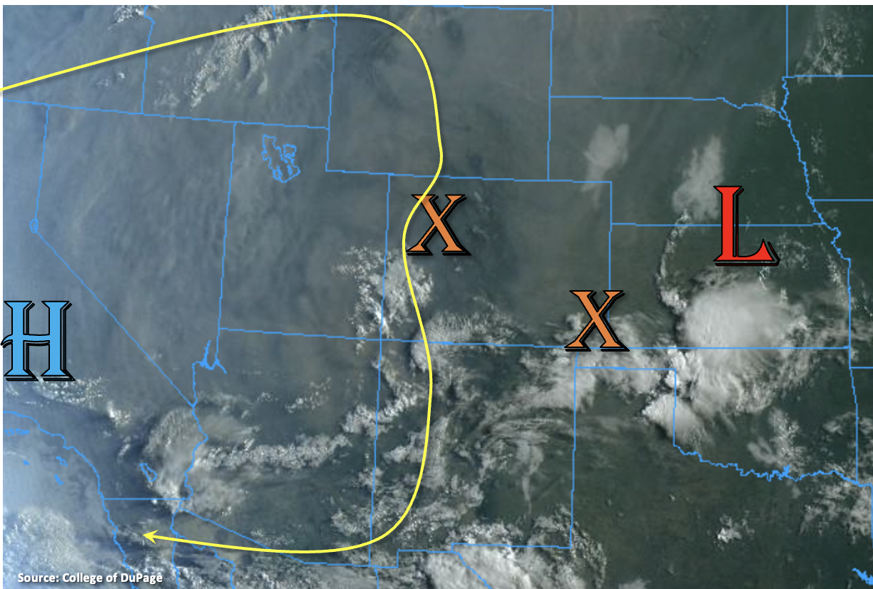
Visible satellite imagery below shows the 500mb High further west this morning, and plenty of smoke out West from the ongoing fires (gray hue). Colorado remains under northerly flow over the western border, which is moving a disturbance south this morning (orange “X”). There is another disturbance over the far Southeast Plains, and both disturbances are creating cloud cover with some embedded rainfall. Today, an incoming, west coast trough will start to push the High first south then west. That will place Colorado under both northerly and variable upper-level flow. Mid-level lift is forecast to remain over the western portion of the state, which will help generate more widespread showers and thunderstorms over the high terrains, especially south.
Drier and stable conditions east of the Continental Divide are expected keep the area mostly rain-free today, although storms will be likely once again along and near the Divide and perhaps south over the southern Southeast Mountains. PW at Grand Junction remains around the same as yesterday (0.79 inches), but with slower steering flows and some training storms forecast, local accumulations should get a boost. Morning cloud cover may limit the coverage of instability, but some pockets of greater instability should still be able to form with strong August heating. That should allow for some stronger thunderstorms to develop over the Southwest Slope and San Juan Mountains that will be capable of producing heavy rainfall in their storm cores. Increased runoff may also be an issue if storms track over the areas that have received rainfall the last couple of days. A LOW flood threat has been issued.
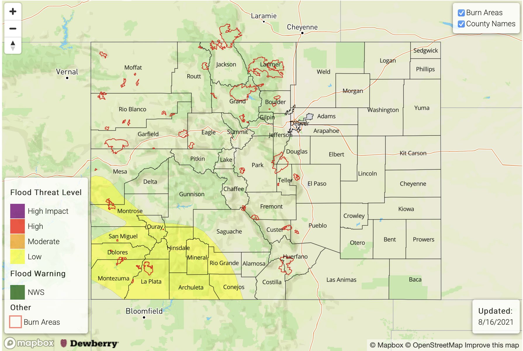
Today’s Flood Threat Map
For more information on today’s flood threat, see the map below. If there is a threat, hover over the threat areas for more details, and click on burn areas to learn more about them. For Zone-Specific forecasts, scroll below the threat map.
Zone-Specific Forecasts:
Grand Valley, Central Mountains, San Luis Valley, San Juan Mountains, Northwest Slope, Northern Mountains, & Southwest Slope:
Max 1-hour rain rates up to 1.25 inches with storm totals up to 1.75 inches will be possible over the San Juan Mountains and Southwest Slope this afternoon where stronger instability can develop. Cloud cover is already starting to break-up, which indicates more instability may be able to build. This could lead to isolated road flooding, mud flows/debris slides and local stream flooding, especially if storms track over the same areas as the last couple of days. Additional threats include strong outflow winds and perhaps some hail. A LOW flood threat has been issued. Storms to the north should be anchored to the high terrains with the weak northerly steering flow. Max 1-hour rain rates up to 0.50 inches will be possible with more storms producing totals around 0.25 inches. Lower elevations should stay dry.
Primetime: 12:30PM to 10PM
Northeast Plains, Urban Corridor, Raton Ridge, Palmer Ridge, Southeast Plains, Southeast Mountains & Front Range:
More stable conditions are forecast across the lower elevations this afternoon, which should keep rainfall confined to areas along and near the Continental Divide. There could also be a couple storms that form over the southern Southeast Mountains. Isolated max 1-hour rain rates up to 0.75 inches will be possible (central/south) with storms that develop over the Northern Front Range producing totals closer to 0.30 inches. Over the far Southeast Plains, if storms can overcome the cap along a dryline, 1-hour rain rates up to 1.25 inches will be possible. First, we’ll need the cloud cover to clear out and mid-level energy to move through the area during peak heating. We’ve got the first ingredient already occurring. Flooding is NOT forecast for these regions today.
Primetime: 1PM to 8PM