Issue Date: Wednesday, August 18th, 2021
Issue Time: 9:45AM MDT
— A MODERATE flood threat has been issued for the Grand Valley, Southwest Slope and southern Northwest Slope
— A LOW flood threat has been issued for the San Juan Mountains, Central Mountains and Northern Mountains
Note this is an overnight threat with a second round of rainfall arriving at the western border by early tomorrow morning
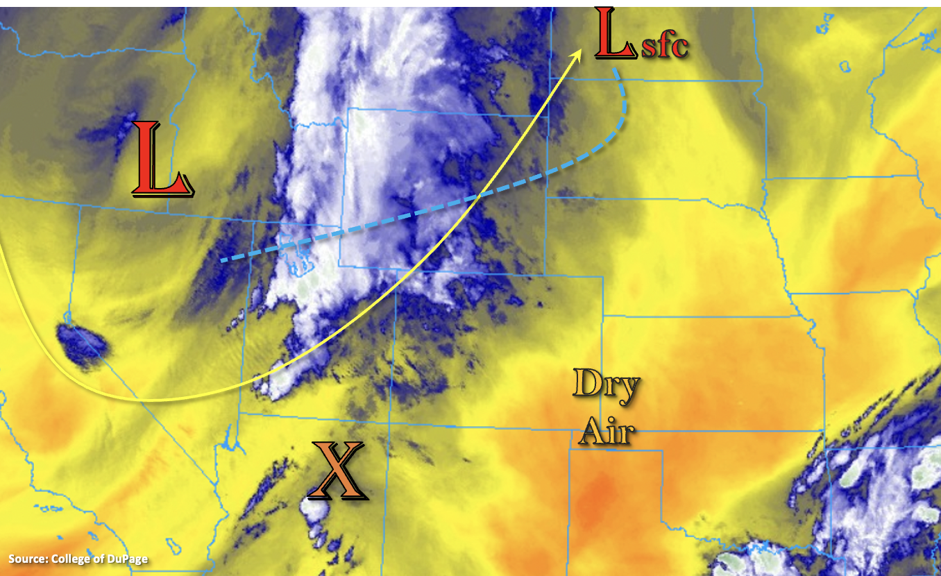
The combination of increasing southwesterly flow aloft and an incoming cold front associated with the troughing pattern will generate the next moisture surge into western Colorado today. An uptick in dynamics with the approaching cold front and jet stream is also anticipated, which means more widespread storms and a couple severe thunderstorms will be possible out west. With PW rising to close to an inch across the western border (0.92 inches this morning), storms that develop today are expected to pose a heavy rainfall threat. Slightly faster steering flows with the incoming jet will likely aid in limiting the threat over any one area, and ongoing showers this morning may help to limit the areal coverage of instability that can develop this afternoon and evening. Nonetheless, mid-level lift and moisture will be plentiful for widespread coverage of stronger storms, and the increasing southwesterly flow will help to pull additional disturbances to our southwest into Southwest Slope and San Juan Mountains.
Initially, the flood threat today will be on the 1 to 2 hour timescale due to the possibility of training storms, but by tonight and into tomorrow morning, the flood threat turns to more of a 3 to 6 hour threat with multiple waves of rainfall forecast over the next 48-hours. Higher-end local accumulations from longer duration rainfall, as well as the quick downpours from storms this afternoon and evening, are forecast to cause an increasing threat for mud flows/debris slides, road flooding and local creek/stream flooding. A MODERATE flood threat has been issued for portions of western Colorado, and the flood threat will continue overnight and into tomorrow morning.
Over eastern Colorado, especially the Southeast Plains, dry air and southwesterly steering flow should keep the plains and Southeast Mountains dry this afternoon. There’s a better chance for some spillover storms along the Front Range and Urban Corridor, but faster storm movement and slightly lower moisture should create more of a wind than heavy rainfall threat. Nuisance road and low-lying area ponding may be possible under the stronger storms that develop (north), but flooding is not forecast for this area.
Today’s Flood Threat Map
For more information on today’s flood threat, see the map below. If there is a threat, hover over the threat areas for more details, and click on burn areas to learn more about them. For Zone-Specific forecasts, scroll below the threat map.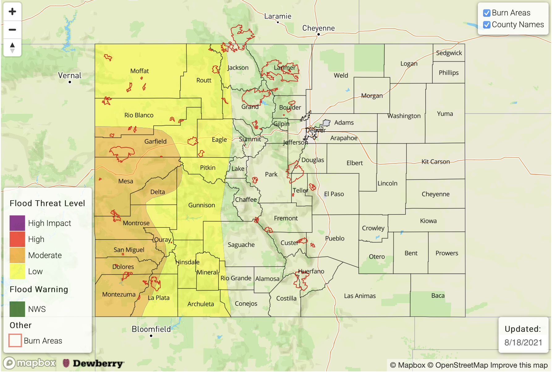
Zone-Specific Forecasts:
Grand Valley, Southwest Slope, Central Mountains, San Juan Mountains, Northwest Slope & Northern Mountains:
Widespread rainfall is forecast with the incoming trough along with cooler temperatures today. Storm movement towards the northeast will be relatively fast, but training storms may help to increase local totals. Storms initially will be capable of producing 1-hour rain rates up to 1.50 inches, and a couple severe storms may be possible over the border counties. The main threats will be strong outflow winds and large hail, but a brief weak tornado is also possible. By this evening and into tomorrow morning, the rainfall threat becomes longer duration (3 to 6 hour) with the upper-level jet aiding in lift for overnight rainfall. Totals by tomorrow morning up to 2.50 inches over the Grand Valley and Southwest Slope forecast regions will be possible. Flood threats over the next 24-hours include local stream/creek flooding, mud flows and debris slides (steeper terrains) and road flooding. A MODERATE flood threat has been issued. Note that a second round of rainfall will likely arrive to western Colorado early tomorrow morning before the next flood threat bulletin is released.
Primetime: 1PM to Ongoing
Southeast Mountains, Front Range, San Luis Valley, Northeast Plains, Urban Corridor, Raton Ridge, Palmer Ridge & Southeast Plains:
Southwest steering flows should keep dry air in place over the plains, Raton Ridge, San Luis Valley and Southeast Mountains limiting the chances for precipitation. A couple high-based storms may drop light rainfall over the Southeast Mountains, so flooding is NOT anticipated. Better chance for storm spillover and a couple thunderstorms will be across the Front Range, Palmer Ridge and Urban Corridor. Max 1-hour rain rates up to 0.40 inches will be possible. This could cause some nuisance ponding in low-lying areas/intersections over impervious areas, but flooding is NOT forecast.
Primetime: 2PM to 11:30PM