FTB 09-08-2021: Warm, Dry and Smoky Day Ahead

Issue Date: Wednesday, September 8th, 2021
Issue Time: 8:15AM MDT

— Flooding is NOT expected today

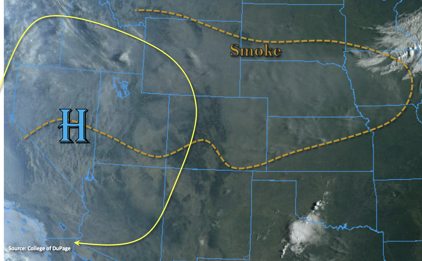
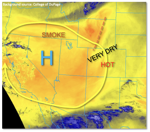
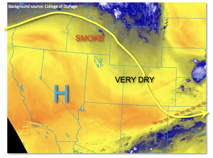
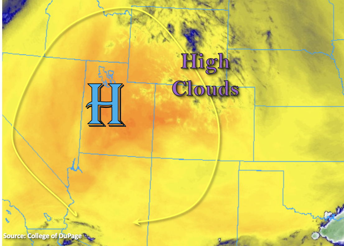
No large changes in the overall pattern as Colorado continues to be under the influence of the High to our west. There are a few high clouds this morning over the northern portion of the state, but they’re likely hard to see with all the smoke over the area. Most of western Colorado and the Front Range/Urban Corridor are under an Air Quality Alert for this wildfire smoke and/or high ozone concentration. Expect the smoky conditions to continue with the thickest near-surface smoke today over the north/central mountains, Grand Valley and Northwest Slope. As far as rainfall, sinking motion and the general lack of moisture with the dry air overhead mean another day without any rainfall statewide. Just how dry is it? PW at Grand Junction has dropped to 0.24 inches, which ties the daily minimum record. As predicted, flooding is not forecast.

Today’s Flood Threat Map

For more information on today’s flood threat, see the map below. If there is a threat, hover over the threat areas for more details, and click on burn areas to learn more about them. For Zone-Specific forecasts, scroll below the threat map.

Zone-Specific Forecasts:

Southeast Mountains, Front Range, Southeast Plains, Northeast Plains, Raton Ridge, Urban Corridor & Palmer Ridge:

Cooler start to the morning with a little high cloud cover over the Front Range and Urban Corridor. It’s also very smoky outside, and there are still high ozone concentrations, too. An Air Quality Alert has been issued for the Front Range, Urban Corridor and Palmer Ridge for these reasons. Temperatures will likely get a couple degrees warmer this afternoon with 90Fs further south and upper 80Fs north/central across the lower elevations. Rainfall is not forecast today.

San Juan Mountains, Central Mountains, Northern Mountains, Southwest Slope, San Luis Valley, Grand Valley & Northwest Slope:

Expect thick near surface smoke today across nearly all forecast zones. A little better visibility will be likely across the southern border over the Southwest Slope, San Luis Valley and San Juan Mountains. An Air Quality Alert has been issued, and if visibility from the smoke is under 5 miles, it has reach unhealthy levels to be outside. Highs will reach into the low to mid-90Fs across the lower elevations with mountain valleys in the 80Fs. Rainfall is not forecast today.

FTB 09-07-2021: Dry With Increasing Smoke

Issue Date: Tuesday, September 7th, 2021
Issue Time: 8:30AM MDT

— Flooding is NOT expected today

It’s a little bit of a warmer of a start to the morning than yesterday, and even though there are cloud-free skies, there’s still plenty of smoke across the state. North and northwest flow aloft will continue today as the High strengthens and moves slightly eastward. Between the subsidence from the High and the dry air still overhead, rainfall is not anticipated today. Afternoon and evening high temperatures should reach into the upper 80Fs and low 90Fs across the lower elevations with upper 70Fs to low 80Fs for the mountain valleys.

The flow around the High and a northerly component to the surface winds this afternoon will continue to advect more smoke into Colorado, which is marked in the visible satellite imagery below. The thickest near surface smoke is anticipated over the Northern/Central Mountains, Grand Valley and Northwest Slope by this evening. Pockets of visibility are forecast to drop between 5 and 10 miles with poor visibility expanding throughout the Northwest Slope and portions of the Northern Mountains by morning. Stay tuned into your local NWS office for the latest on Air Quality Alerts issued over the next few days.

Today’s Flood Threat Map

For more information on today’s flood threat, see the map below. If there is a threat, hover over the threat areas for more details, and click on burn areas to learn more about them. For Zone-Specific forecasts, scroll below the threat map.

Zone-Specific Forecasts:

San Juan Mountains, Central Mountains, Northern Mountains, Southwest Slope, San Luis Valley, Grand Valley & Northwest Slope:

Expect surface visibility to drop throughout the day with the ongoing fires and plume moving in from the north. Afternoon and evening high temperatures will reach into the 90Fs for the valleys and low 80Fs for the mountain valleys. Rainfall is NOT forecast today.

Southeast Mountains, Front Range, Southeast Plains, Northeast Plains, Raton Ridge, Urban Corridor & Palmer Ridge:

Too dry for any rainfall today with PW measured at 0.34 inches in Denver this morning. Smoky conditions will continue with visibility continuing to drop over the next 24 hours. Highs should reach the upper 80Fs into the low 90Fs over the Urban Corridor and eastern plains with mountain valleys in the upper 70Fs to low 80Fs. Flooding is NOT expected.

FTB 09-06-2021: Hot And Sunny Labor Day For Most

Issue Date: Monday, September 6th, 2021
Issue Time: 8:50AM MDT

— Flooding is NOT expected today

Colorado awoke to “severe clear” skies on this Labor Day morning, meaning there was not a cloud to be seen. For the vast majority of the state, Mother Nature will conveniently provide a sunny holiday. As shown in the water vapor image, below, an upper-level ridge is currently centered over Nevada with Colorado lying under a stream of very dry northwesterly flow around its periphery. With the ridge strengthening over the past 24 hours, expect temperatures to warm this afternoon by 5F or more degrees compared to Sunday. Additionally, some smoke will continue to stream into northern Colorado today, although concentrations are expected to remain relatively low (especially compared to the much more severe events we experienced earlier this summer).

Moisture levels continue to be very low, with Precipitable Water (PW) once again below 0.5 inches at Denver and Grand Junction this morning. Higher PW, up to 0.8 inches, was estimated over far southeast Colorado. A disturbance racing southeastward out of WY this afternoon will mainly produce some gusty winds over eastern Colorado. However, with weak, modestly moist upslope flow remaining east of the Raton Ridge, an isolated thunderstorm cannot be ruled out again for Baca County. But with such a dry boundary layer, rainfall will be hard to come by and flooding is NOT expected today.

Today’s Flood Threat Map

For more information on today’s flood threat, see the map below. If there is a threat, hover over the threat areas for more details, and click on burn areas to learn more about them. For Zone-Specific forecasts, scroll below the threat map.

Zone-Specific Forecasts:

Southeast Plains:

Mostly sunny and warmer this afternoon with an isolated shower or storm possible over Baca County. Max 1-hour rainfall up to 0.4 inches. Hail up to 0.75 inches will be possible if a strong storm manages to develop. However, flooding is NOT expected today.

Primetime: 2PM through 7PM

Southwest Slope, Grand Valley, Northwest Slope, Central Mountains, Northern Mountains, San Juan Mountains, San Luis Valley, Front Range, Urban Corridor, Palmer Ridge, Northeast Plains, Raton Ridge and Southeast Mountains:

Mainly sunny and warmer today, with some gusty winds possible over the higher terrain and foothills this afternoon. Flooding is NOT expected.

FTB 09-05-2021: A Sunny Sunday For Most

Issue Date: Sunday, September 5th, 2021
Issue Time: 9:00AM MDT

Flooding is NOT expected today

The long advertised drying has finally occurred in earnest across Colorado overnight. Dewpoint temperatures have dropped anywhere from 5F-25F statewide, with the most significant drying over northern Colorado. Precipitable Water (PW) has dropped below 0.5 inches at both Denver and Grand Junction. As shown in the water vapor image, below, northwesterly flow around a strengthening Four Corners ridge will continue to stream very dry air into the state. Seasonable temperatures are expected this afternoon, despite the ample sunshine. A bit of smoky air could make it into northern Colorado this afternoon, but heavier smoke concentrations are expected to hold off until Monday and Tuesday.

An isolated shower or weak storm cannot be ruled out over southeastern Colorado, mainly in Baca County as well as the southernmost portion of the Southeast Mountains. However, with strong steering winds and limited boundary layer moisture, only light accumulation would occur if a storm did manage to pop. Thus, flooding is NOT expected today.

Today’s Flood Threat Map

For more information on today’s flood threat, see the map below. If there is a threat, hover over the threat areas for more details, and click on burn areas to learn more about them. For Zone-Specific forecasts, scroll below the threat map.

Zone-Specific Forecasts:

Southeast Plains, Raton Ridge and Southeast Mountains:

Mostly sunny and seasonably warm this afternoon with an isolated shower or weak storm possible over Baca County, as well as the NM border portion of the Southeast Mountains. Max 1-hour rainfall up to 0.4 inches (Baca County) and 0.2 inches (Southeast Mountains). Flooding is NOT expected today.
Primetime: 2PM through 9PM

Southwest Slope, Grand Valley, Northwest Slope, Central Mountains, Northern Mountains, San Juan Mountains, San Luis Valley, Front Range, Urban Corridor, Palmer Ridge and Northeast Plains:

Mostly sunny and seasonably warm today. Flooding is NOT expected.