Issue Date: Monday, September 6th, 2021
Issue Time: 8:50AM MDT
— Flooding is NOT expected today
Colorado awoke to “severe clear” skies on this Labor Day morning, meaning there was not a cloud to be seen. For the vast majority of the state, Mother Nature will conveniently provide a sunny holiday. As shown in the water vapor image, below, an upper-level ridge is currently centered over Nevada with Colorado lying under a stream of very dry northwesterly flow around its periphery. With the ridge strengthening over the past 24 hours, expect temperatures to warm this afternoon by 5F or more degrees compared to Sunday. Additionally, some smoke will continue to stream into northern Colorado today, although concentrations are expected to remain relatively low (especially compared to the much more severe events we experienced earlier this summer).
Moisture levels continue to be very low, with Precipitable Water (PW) once again below 0.5 inches at Denver and Grand Junction this morning. Higher PW, up to 0.8 inches, was estimated over far southeast Colorado. A disturbance racing southeastward out of WY this afternoon will mainly produce some gusty winds over eastern Colorado. However, with weak, modestly moist upslope flow remaining east of the Raton Ridge, an isolated thunderstorm cannot be ruled out again for Baca County. But with such a dry boundary layer, rainfall will be hard to come by and flooding is NOT expected today.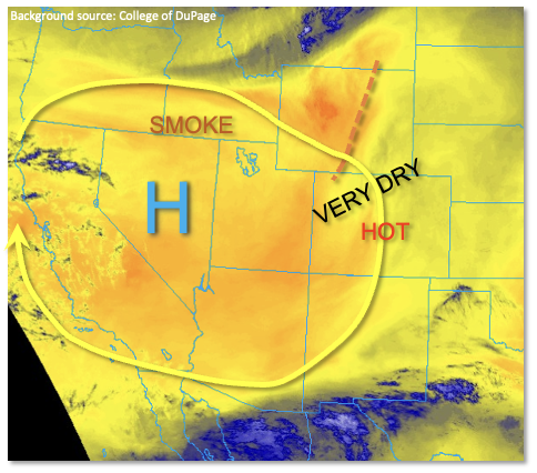
Today’s Flood Threat Map
For more information on today’s flood threat, see the map below. If there is a threat, hover over the threat areas for more details, and click on burn areas to learn more about them. For Zone-Specific forecasts, scroll below the threat map.
Zone-Specific Forecasts:
Southeast Plains:
Mostly sunny and warmer this afternoon with an isolated shower or storm possible over Baca County. Max 1-hour rainfall up to 0.4 inches. Hail up to 0.75 inches will be possible if a strong storm manages to develop. However, flooding is NOT expected today.
Primetime: 2PM through 7PM
Southwest Slope, Grand Valley, Northwest Slope, Central Mountains, Northern Mountains, San Juan Mountains, San Luis Valley, Front Range, Urban Corridor, Palmer Ridge, Northeast Plains, Raton Ridge and Southeast Mountains:
Mainly sunny and warmer today, with some gusty winds possible over the higher terrain and foothills this afternoon. Flooding is NOT expected.