FTB 05-09-2022: Extreme Fire Weather and Strong Wind Gusts

Issue Date: Monday, May 9th, 2022
Issue Time: 9:45AM MDT

Flooding is NOT expected today
Widespread Red Flag Warnings in effect

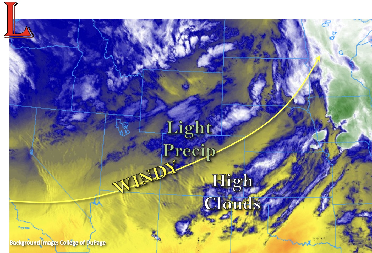
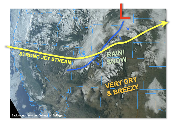
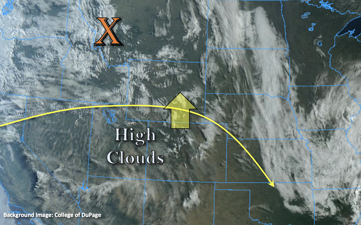
The large trough over the Pacific Northwest will continue to churn over that area for the next 24-hours, so we’re looking at a similar set up to yesterday with a few minor changes. The surface Low from yesterday has moved into central Nebraska, and northerly winds behind it have created cooler conditions for areas north of I-70. While dew points in this area are only moderate (30Fs and 40Fs), there’s enough residual moisture and mid-level instability from the jet to generate some weak showers and snowfall over the Northern Mountains and northern Front Range. PW values remain meager today, but there is likely just enough moisture to continue this light precipitation through the early afternoon hours. However, once again, only minimal accumulation is forecast, so there is NO flood threat issued.

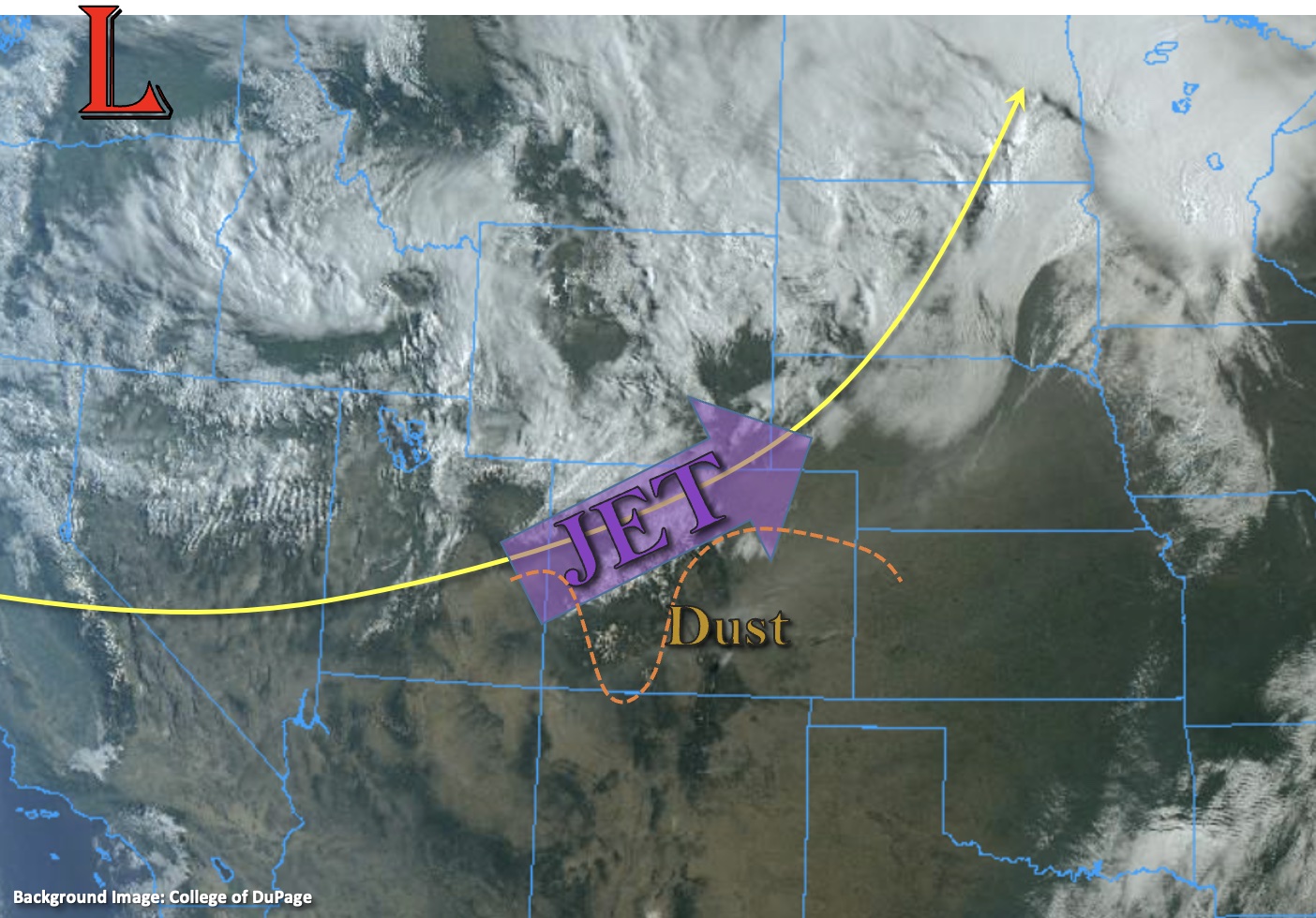
To the south of this area, dry and windy conditions are forecast to persist. Very strong southwest winds continue at the mid and upper levels over the state this morning. There was already a gust of 52 mph recorded above Antero Reservoir in Park County, and dust can be seen in the visible satellite imagery below. With a little more daytime heating, stronger winds will be quick to mix down to the surface. With windy conditions continuing, and the dry air mass overhead, very high fire danger will continue for areas south of the orange dashed line below. This means another round of Red Flag Warnings have been issued. One other minor difference from yesterday is that the trough will begin to dig south later this afternoon, which should give the southwest surface winds across the state a slightly more southerly component. Unlike yesterday, winds will begin to decouple by later this afternoon, so there will be a break in windy conditions for most until tomorrow.

Today’s Flood Threat Map

For more information on today’s flood threat, see the map below. If there is a threat, hover over the threat areas for more details, and click on burn areas to learn more about them. For Zone-Specific forecasts, scroll below the threat map.

Zone-Specific Forecasts:

Northern Mountains, Front Range, Grand Valley, Northwest Slope, Urban Corridor & Northeast Plains:

Light showers and snow are falling over portions of the Northern Mountains and northern Front Range this morning. There’s just enough moisture that this scattered precipitation could persist through the early afternoon hours. It’s unlikely any rainfall will survive over the northern Urban Corridor today. Isolated totals up to 0.40 inches may be possible again over the Northern Mountains. Flooding is NOT expected. High temperatures are forecast in the 70Fs for the lower elevations east/west and low 60Fs are forecast over the mountains/Northwest Slope.

Windy and dry conditions are forecast for the southern Front Range and Urban Corridor by midday. A Red Flag Warning has been issued with gusts up to 35 mph possible.

Primetime: Ongoing to 1PM

Palmer Ridge, Southeast Plains, Southeast Mountains, Raton Ridge, Central Mountains, San Luis Valley, San Juan Mountains, & Southwest Slope:

Extreme fire danger continues through this evening, so Red Flag Warnings have been issued for all or portions of these forecast zones. A High Wind Warning continues through noon for the south-central mountains and Southeast Mountains. Winds begin to decrease by later this afternoon and should decouple or stop for most areas by this evening. The exception is over the southern Southeast Mountains and southern eastern San Juan Mountains where gusts may continue overnight. Too dry for any rainfall, so flooding is NOT forecast. Be sure to tune into your local NWS office for the details pertaining to fire danger over your area. High temperatures are forecast to reach the upper 60Fs and 70Fs west and upper 80Fs/low 90Fs east (lower elevations). Mountain valleys will likely reach the low to mid-60Fs.

FTB 05-08-2022: High Fire Danger + Heat Continues for Mother’s Day

Issue Date: Sunday, May 8th, 2022
Issue Time: 8:55AM MDT

  Flooding is NOT expected today
Widespread Red Flag Warnings in effect

The unseasonably warm early May temperatures will continue for another day, and highs are expected to reach into the 70Fs and low 80Fs across the lower elevations with upper 80Fs forecast over southeast Colorado. This morning, there are some light showers occurring over the northern mountains and high clouds over the southwest corner of the state as shown in the water vapor imagery below. As the Low over the Pacific Northwest slowly begins to move inward today, southwest flow is forecast to increase across the state. This will usher in a very dry air mass and mix out any residual moisture from yesterday over the mountains. Just how dry is it? PW to our south of our border was measuring just under a quarter of an inch this morning.

This very dry air mass will help to drop dew points into the teens, which will limit rainfall chances to nearly zero across the state this afternoon and evening. There is a slight chance for some light precipitation over the elevated regions of the Northwest Slope and Northern Mountains overnight as a weak shortwave moves through the flow, but accumulation should remain minimal with plenty of virga. As anticipated, there is NO flood threat issued today.

Additionally, the mixing down of strong upper-level winds and development of a surface Low over the Palmer Ridge will cause very windy conditions for most of the state. Expect strong southwest winds to develop over western Colorado and the mountains by midday, and (lighter) SSE winds to develop over the eastern plains. As one can imagine, the very dry air mass paired with strong surface winds means that high fire danger will continue, and a large portion of the state is under a Red Flag Warning. Moreover, a High Wind Warning has been issued for the south-central portion of the state. More details can be found in the zone-specific forecasts below and from your local NWS office.

Today’s Flood Threat Map

For more information on today’s flood threat, see the map below. If there is a threat, hover over the threat areas for more details, and click on burn areas to learn more about them. For Zone-Specific forecasts, scroll below the threat map.

Zone-Specific Forecasts: 

Northern Mountains, Front Range, Northwest Slope, Urban Corridor & Northeast Plains:

As the day continues, it’s likely that the dry air mass moving over the state will cut down on the chances for much, if any, afternoon and evening precipitation accumulation over the Northern and northern Front Range Mountains. A shortwave moves through the same area overnight, which may cause some light precipitation and snow to fall for the highest elevations for this region (northern border). Localized totals could reach up to 0.50 inches. Slightly cooler temperatures are forecast today, although highs will still reach into the mid-70Fs. Wind chances and fire danger are also less compared to south of I-70, although spotty windy conditions are possible over the northern and western high terrains (20-25 mph).

Primetime: 10PM to 6AM

Palmer Ridge, Southeast Plains, Southeast Mountains, Raton Ridge, Central Mountains, San Luis Valley, San Juan Mountains, Grand Valley, & Southwest Slope:

Very high fire danger today, so avoid activities that could create a spark. At least a portion of each of these forecast regions is under a Red Flag Warning. In addition to the large Red Flag Warning, a High Wind Warning has been issued for the south-central portion of the state. Over the San Luis Valley, sustained winds in the 30-40 mph range are forecast with gusts up to 65 mph possible. Over the southern Central/Southeast Mountains and Raton Ridge southwest winds in the 40-50 mph are forecast with gusts up to 85 mph possible over the mountain regions. High temperatures will reach into the upper 80Fs over the eastern plains, 60Fs for the mountain valleys and 70Fs for the lower elevations west and central. Rainfall is NOT forecast today.

FTB 05-07-2022: Cool Front Passage To Provide Limited Rain/Snow, Also Start A 3-Day Windy Stretch Statewide

Issue Date: Saturday, May 7th, 2022
Issue Time: 8:48AM MDT

— Flooding is NOT expected today
Widespread Red Flag Warnings in effect

A very strong jet stream is positioned mainly zonally (i.e. east/west) across the western United States. To its north, a large-scale trough will begin its grip on the west coast for the foreseeable future, sending an array of disturbances that will graze Colorado over the next 7 days. One such disturbance will be passing through today, led by a cool front currently draped across WY and UT. With limited instability, extremely fast steering wind and only modest moisture, precipitation amounts are expected to stay on the lighter side, with two parts of the state being favored. First, over the Northern Mountains, a couple of rounds of precipitation are expected this afternoon and into the evening/overnight hours delivering perhaps up to 0.5 inches of liquid equivalent by tomorrow morning. Second, along the NE/KS border of the Northeast Plains, an isolated storm cannot be ruled out this afternoon, then followed by scattered showers accompanying the frontal passage overnight. Overall, flooding is NOT expected today.

The big story, of course, will be the very windy conditions almost statewide, which has prompted widespread Red Flag Warnings covering three quarters of our state. Please be careful today and do your part to limit wildfire potential.

Today’s Flood Threat Map

For more information on today’s flood threat, see the map below. If there is a threat, hover over the threat areas for more details, and click on burn areas to learn more about them. For Zone-Specific forecasts, scroll below the threat map.

Zone-Specific Forecasts:

Northwest Slope, Central Mountains, Northern Mountains:

Increasing clouds and cooler with scattered to numerous rain showers, mixing with snow by later in the afternoon especially over the higher elevations. Thunder is also possible. Max 1-hour rainfall up to 0.3 inches. Flooding is NOT expected today.

Another round of precipitation in the form of rain and snow is expected overnight, with up to 0.5 inches of liquid equivalent possible over the favored higher west-facing peaks by tomorrow morning.

Primetime: Noon through the overnight hours

Northeast Plains:

Mostly sunny and hot today with breezy conditions developing by afternoon. An isolated thunderstorm cannot be ruled out right along the KS border. Max 1-hour rainfall limited to 0.5 inches as storms will quickly leave into KS/NE. Later in the evening, a cool front passage will lead to scattered showers over northeastern areas close to the NE/KS border. Up to 0.5 inches of welcome rainfall could occur over a few hours. Flooding is NOT expected today.

Primetime: 3PM to 6PM, then again late evening and into overnight hours

Front Range, Urban Corridor, Southeast Plains, Grand Valley, San Juan Mountains, Southwest Slope, San Luis Valley, Northwest Slope, Southeast Mountains & Raton Ridge:

Partly cloudy and very warm this afternoon with very windy conditions developing by afternoon. Gusts exceeding 60mph are expected across most of the higher terrain. Flooding is NOT expected today.

Widespread Red Flag Warnings are in effect for most of this area. Stay tuned to NWS for updates. Please be careful and do your part in preventing wildfires.

FTB 05-06-2022: Warming Up, But Increasing Fire Danger Heading into the Weekend

Issue Date: Friday, May 6th, 2022
Issue Time: 8:45AM MDT

— Flooding is NOT expected today

The ridging pattern that established itself yesterday will persist and build today, which paired with westerly winds, is expected to increase afternoon high temperatures statewide. The visible satellite imagery (below) shows a weak shortwave to our north with a larger shortwave coming in behind it. Not a lot of moisture with this initial portion of the system, as can be seen by only broken high clouds over the Southwest in the image below. Lack of moisture and large-scale lift over the state mean that dry conditions are forecast once again. So, flooding is NOT expected. Overall, it’s looking at another warm and pleasant day ahead.

The passing trough, and a surface Low developing to our northeast, will cause breezy westerly/northwesterly flow by noon. Strong wind gusts (45-55 mph) are forecast over the highest elevations of the North, Central and Front Range Mountains, and to a lesser extent over the Southeast Mountains by late morning. These should begin to subside by late afternoon. Another Red Flag Warning has also been issued over the San Luis Valley.

Today’s Flood Threat Map

For more information on today’s flood threat, see the map below. If there is a threat, hover over the threat areas for more details, and click on burn areas to learn more about them. For Zone-Specific forecasts, scroll below the threat map.

Zone-Specific Forecasts:

Northern Mountains, Southeast Mountains, Front Range & Central Mountains:

No rain is anticipated this afternoon or evening, but there will likely be an increase in cloudiness throughout the day. Windy conditions (from the west) are forecast by late morning and should last through late afternoon. Gusts could reach 45 to 55 mph over the highest peaks. Afternoon high temperatures for the mountain valleys are forecast to reach into the mid-60Fs.

Palmer Ridge, Urban Corridor, Northeast Plains, Southeast Plains & Raton Ridge:

Dry conditions are forecast today with an increasing west/northwest breeze by this afternoon. Gusts could reach up to 30 mph over portions of the eastern plains and Palmer Ridge. Afternoon high temperatures will be on the rise with the downslope winds lending a helping hand there, and highs are expected to reach into the 80Fs.

San Luis Valley, San Juan Mountains, Grand Valley, Northwest Slope & Southwest Slope:

Clear conditions and warming temperatures are forecast today with highs reaching into the 80Fs across the lower elevations and 60Fs for the mountain valleys. Rainfall is not forecast today. A Red Flag Warning has been issued again for the San Luis Valley. Up to date information for that warning can be found on the NWS Pueblo site.