Issue Date: June 10th, 2015
Issue Time: 10:55 AM (Updated 3PM)
— Moderate flood threat for Palmer Divide and parts of Northeast Plains
— Low flood threat for Northeast Plains, Urban Corridor, Front Range, parts of Palmer Ridge and parts of Southeast Plains
— Low flood threat for Central Mountains, Northern Mountains, parts of Grand Valley and parts of San Juans
— Low flood threat for parts of Arkansas and South Platte River
Afternoon update: Active period from 3PM-8PM across the Urban Corridor and most of Eastern Colorado as disturbance moves eastward off the higher terrain. All Flood threats maintained, plus Low flood threat added for Southeast Plains. Activity expected to subside after sunset.
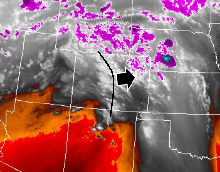
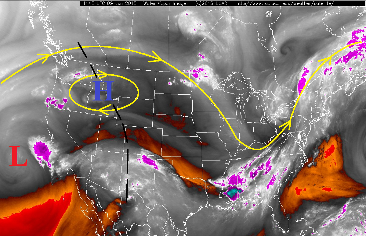
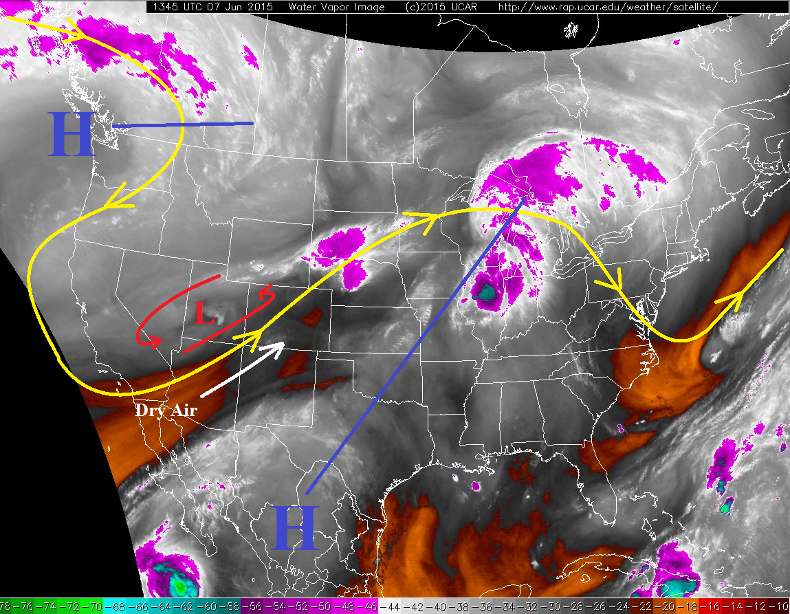
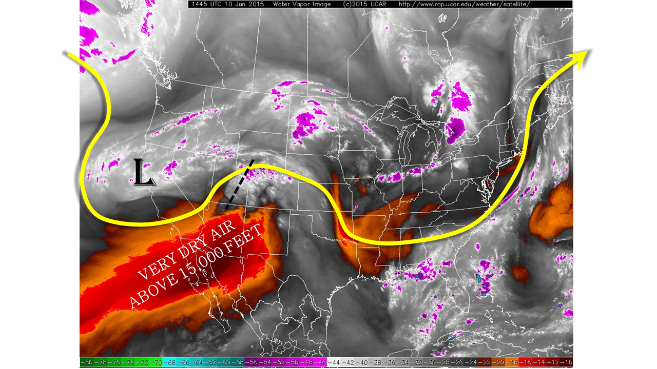
An active weather day is on tap for many across Colorado. Surface dew points this morning are in the 50s across many lower elevation locations. Precipitable water values are at or above 1 inch at Pueblo, Grand Junction and Boulder. Moist upslope flow is present for many east of the Divide. The water vapor image, below, shows additional critical information. First is the presence of an upper-level low to the west. Though this feature is still far away, it will send off several disturbances that will promote periods of upward motion throughout the day. On the other hand, one important negative factor is a large swath of extremely dry upper-level air noted across Arizona and western parts of Mexico. This airmass will try to impede northeastward into Colorado, but will have to compete with thunderstorms sending large amounts of moisture upward. We expect the upper-level drying to provide a cap on the heavy rainfall threat across a large portion of southeast Colorado.
For today, we expect ongoing shower and thunderstorm activity to continue both west and east of the Divide. Over the higher terrain, rainfall on top of the snowmelt will continue to support a Low flood threat. Meanwhile, farther east, thunderstorm activity will have access to more moisture, allowing for a heavier rainfall threat. Of particular concern today is the northern parts of the Palmer Ridge, where rainfall up to 2 inches per hour will be possible. A Moderate flood threat has been issued here.
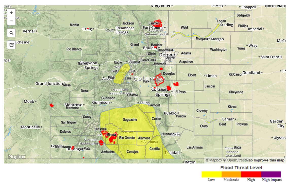
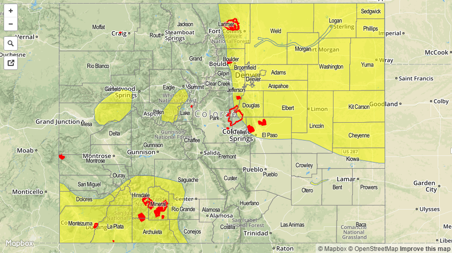
Today’s Flood Threat Map
For more information on today’s flood threat, see the map below (hover over threat areas for more details). For Zone-Specific forecasts, jump below the map.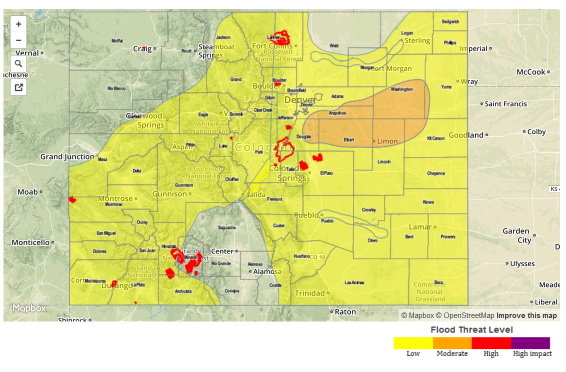 Zone Specific Forecasts
Front Range, Urban Corridor, Northeast Plains and Palmer Divide
Mostly cloudy skies this morning with intermittent sunshine through the early afternoon. Showers and weak thunderstorms are ongoing this morning, but rain rates will be at or below 0.5 inches per hour. By early afternoon, expect stronger thunderstorms to arrive from the west. The strongest storms will produce 1-hour rain rates up to 2 inches, and 3-hr rain rates up to 3 inches. A Moderate flood threat has been posted for parts of the area, surrounded by a Low flood threat. Isolated hail, up to 1.25 inches will be possible with the strongest cells.
Primetime: 2pm through 10pm for the Moderate threat, 2pm through 2am for the Low threat
Southeast Plains, Southeast Mountains, Raton Ridge and San Luis Valley:
Partly cloudy skies with isolated to scattered showers and thunderstorms developing by early afternoon. Drying aloft will translate to the surface and limit rain rates to about 0.6 inches per hour.
Primetime: 2pm through 8pm
Central Mountains, Northern Mountains:
Mostly cloudy skies with scattered to widespread showers and thunderstorms continuing throughout the day. Hourly rain rates up to 1.0 inch will be possible, which combined with the remaining snowmelt, warrants a Low flood threat.
Primetime: 1pm through 9pm
Grand Valley, Northwest Slope, San Juan Mountains and Southwest Slope:
Mostly cloudy with numerous showers and thunderstorms continuing through the early evening before moving off to the east. Hourly rain rates up to 0.9 inches will be possible. Snowmelt is also ongoing across the higher terrain. The combination of the two warrants a Low flood threat mainly for the central and southern areas.
Primetime: 11am through 8pm