Issue Date: 6/9/2015
Issue Time: 10:00 AM
VARIOUS LOW FLOOD THREATS HAVE BEEN ISSUED ACROSS WESTERN COLORADO FOR SNOWMELT AND RUNOFF. CHECK THE FLOOD THREAT MAP BELOW FOR DETAILS.
A LOW FLOOD THREAT CONTINUES FOR PORTIONS OF THE CACHE LA POUDRE, SOUTH PLATTE, AND ARKANSAS RIVERS.
Mid- and Upper-Level high pressure ridging will continue to be in place over Colorado today, leading to another day of limited showers and thunderstorms. There will be a bit more activity than yesterday, thanks to the return of *some* moisture and weaker subsidence aloft, but overall it should be another pleasant day. The higher terrain of the Front Range, Central Mountains, and Northern Mountains will be the main focus for isolated showers and thunderstorms this afternoon/evening, but a couple of storms will also be possible across the Urban Corridor, Northeast Plains, Palmer Ridge, and Raton Ridge. With very little instability and a lack of upper-level support, showers and thunderstorms will be of the garden variety, producing mainly gusty winds and brief light-to-moderate rainfall.
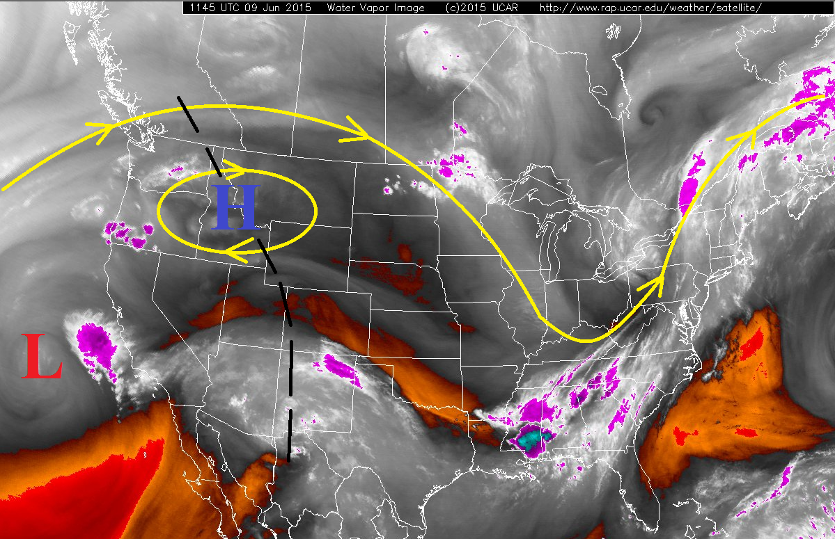
Changes are on the way, though, as the high pressure ridging slides east of the state tonight and an increase in moisture will move in from the southwest. The increased moisture (remnants of former-Hurricane Blanca) will be fed into Colorado thanks to an approaching low pressure system from the west (red “L” on the water vapor image below). The low pressure system is slow-moving because it hasn’t become entrenched with the approaching upper-level trough over the Pacific, so there aren’t big changes coming tonight. It will take a bit longer for the direct effects of the system to be felt. Instead, the increase in moisture will feed an increase in clouds/showers during the late afternoon and evening hours tonight across the Southwest Slope, San Juan Mountains, and Grand Valley. Heavy rainfall is not expected from any showers, but rather this is the precursor to the main event coming over the next few days.
Today’s Flood Threat Map
For more information on today’s flood threat, see the map below (hover over threat areas for more details). For Zone-Specific forecasts, jump below the map.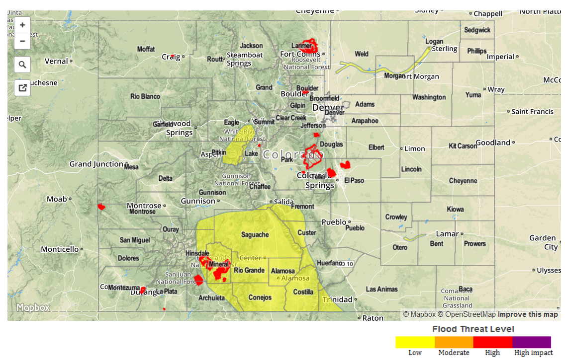
Zone-Specific Forecasts
Urban Corridor, Palmer Ridge, Southeast Plains, Northeast Plains, and Raton Ridge:
Mostly sunny and warm, with temperatures climbing higher than yesterday. A few isolated, afternoon/evening showers and thunderstorms cannot be ruled out, but will most likely occur near enhanced terrain, such as the Palmer Ridge, Raton Ridge, and Cheyenne Ridge.
Rain rates will generally be 0.2-0.4 inches/hour, but a stronger storm or two will be able to produce rain at 0.5-0.7 inches/hour.
Timing: 2 PM – 9 PM
Front Range, Northern Mountains, Northwest Slope, Central Mountains:
Mostly sunny early, becoming partly sunny during the afternoon as isolated showers and weak thunderstorms develop over the ridge tops. Heavy rainfall is not expected from any activity, as rain rates will be in the 0.2-0.4 inches/hour range. Expect activity to diminish quickly around sunset.
Timing: Noon – 9 PM
Grand Valley, San Luis Valley, Southwest Slope, San Juan Mountains, and Southeast Mountains:
Mostly sunny and warm, with a few isolated showers and weak thunderstorms possible over the San Juan Mountains and Southeast Mountains this afternoon/evening thanks to favorable southwest flow. Moisture will begin to increase from the southwest during the late afternoon/evening and continue through the overnight, leading to increasing clouds and a few showers over the higher terrain.
Timing: 2 PM – 9 PM, with a few showers overnight as moisture encroaches further into the state from the southwest.