Issue Date: 6/8/2015
Issue Time: 10:11 AM
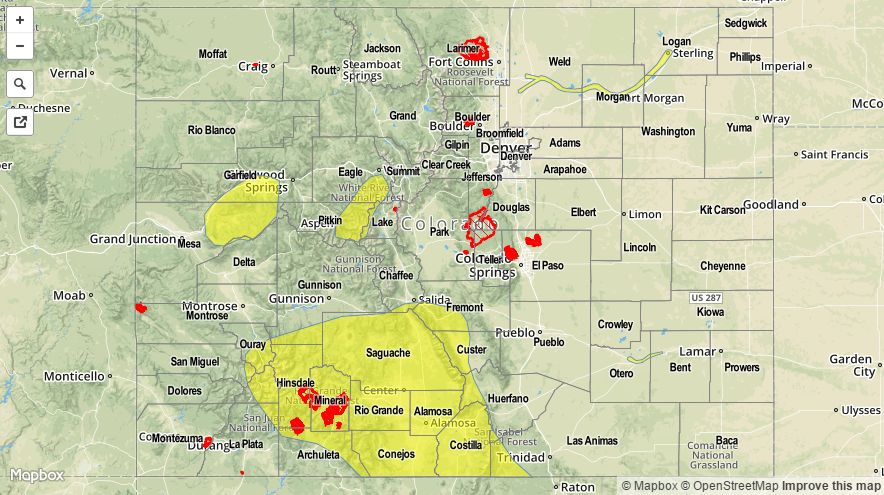
VARIOUS LOW FLOOD THREATS HAVE BEEN ISSUED ACROSS WESTERN COLORADO FOR SNOWMELT, RUNOFF, AND THE WEST SALT CREEK LANDSLIDE AREA. CHECK THE FLOOD THREAT MAP BELOW FOR DETAILS.
A LOW FLOOD THREAT CONTINUES FOR PORTIONS OF THE CACHE LA POUDRE, SOUTH PLATTE, AND ARKANSAS RIVERS.
A much drier day is in store for today, and just typing those words feels like a sigh of relief. The moisture remnants of former Hurricane Andres have moved on to the east as high pressure ridging has built in over the west. Two separate high-pressure ridges are noted in the water vapor image below; one centered over the Pacific NW, the other over SW Texas/Mexico. These two high pressure regions will phase together as the day progresses, placing Colorado under broad-scale subsidence and a much drier air mass. Additionally, surface high pressure continues to build across the state, and this is good news if you are looking for a pleasant day.
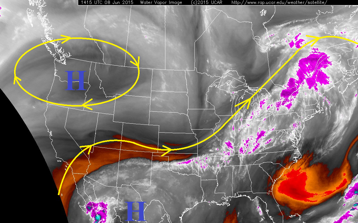
As is the case nearly every day in Colorado, the whole story cannot be explained by the large-scale conditions. Instead, the forecast must account for the impacts of terrain and residual moisture left behind by previous day’s storms. Due to this, isolated showers and weak thunderstorms are expected over the higher terrain, with a few moving over adjacent low elevations thanks to westerly flow aloft. The further away from the mountains and their orographic influences, the less the chances become for any activity.
Today’s Flood Threat Map
For more information on today’s flood threat, see the map below (hover over threat areas for more details). For Zone-Specific forecasts, jump below the map.

Zone-Specific Forecasts
Urban Corridor, Palmer Ridge, Southeast Plains, and Northeast Plains:
Mostly sunny skies and warm temperatures will make for a pleasant Monday. High clouds will increase over the Urban Corridor this afternoon and evening as remnants of higher terrain activity is blown over the area. A couple of showers and weak thunderstorms will attempt to move off of the higher terrain and over adjacent lower elevations, mainly across the Urban Corridor and western portions of the Palmer Ridge. The Northeast Plains will stay dry overall, but the portions of the Southeast Plains that are adjacent to the Southeast Mountains and Raton Ridge will hold a chance for an isolated shower/thunderstorms moving overhead off of the higher terrain this afternoon/evening.
Rain rates will generally be 0.2-0.4 inches/hour, with a potentially stronger storm producing maximum rain rates of 0.6-0.8 inches/hour.
Timing: 3 PM – 10 PM
Front Range, Northern Mountains, Northwest Slope, Central Mountains, San Juan Mountains, Raton Ridge, and Southeast Mountains:
Isolated showers and weak thunderstorms are expected over the ridge tops to break up the otherwise mostly sunny skies. A few showers/weak thunderstorms will move overhead of the adjacent lower valleys, but they will diminish quickly with the loss of orographic support.
The Raton Ridge may see a strong-to-severe thunderstorm or two this afternoon/evening, but otherwise thunderstorms will be garden variety.
Rain rates will generally be 0.2-0.4 inches/hour, but stronger storms over the Raton Ridge will potentially produce 0.6-0.8 inches/hour.
Timing: 11 AM – 10 PM
Grand Valley, San Luis Valley, and Southwest Slope:
Mostly sunny and warm will be the name of the game today, as the lower elevations across these region will not support any shower or thunderstorm activity. The only location with a chance of an isolated shower or two will be over the higher terrain in eastern portions of the Grand Valley Region.