Issue Date: 6/7/2015
Issue Time: 10:24 AM
A LOW FLOOD THREAT IS FORECAST FOR PORTIONS OF THE FRONT RANGE, URBAN CORRIDOR, NORTHEAST PLAINS, SOUTHEAST PLAINS, AND PALMER RIDGE.
A LOW FLOOD THREAT IS FORECAST FOR PORTIONS OF THE SAN JUAN MOUNTAINS AND SOUTHWEST SLOPE.
A LOW FLOOD THREAT CONTINUES DUE TO ACTION-TO-MINOR STAGE FLOODNG FOR PORTIONS OF THE ARKANSAS RIVER, SOUTH PLATTE RIVER, AND CACHE LA POUDRE RIVER.
The upper-level pattern has remained relatively unchanged as the blocking high pressure ridge continues across the central US, keeping southwest flow over Colorado. Making a difference in the pattern is the high pressure ridging building in over the Pacific Northwest, which is helping to elongate/shear the upper-level low that has been responsible for the active period the last few days. This trough will migrate eastward and exit the region soon, but in the meantime, Colorado is left with another day of active weather. With that said, however, the introduction of drier air from the southwest today will help to limit storm coverage slightly.
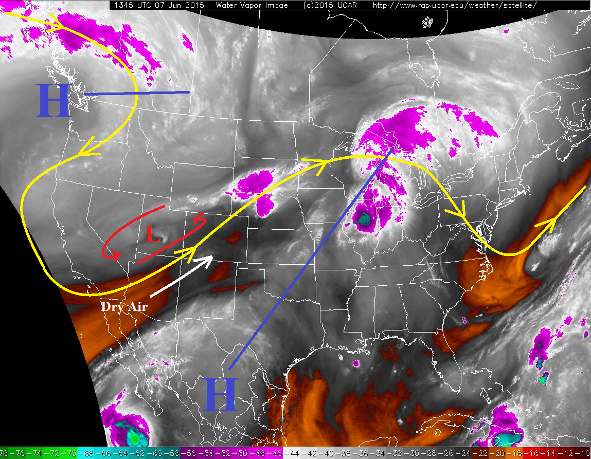
At the surface, a weak front has pushed southward across eastern Colorado, and is now oriented along an East-West line from near Pueblo through Lamar. This has reinforced low-level moisture north of the front, and will provide for another day of strong-to-severe storms east of the mountains, capable of producing heavy rainfall.
The dry air from the southwest will make a bigger impact west of the Continental Divide, leading to slightly higher based storms that will produce rain less efficiently than yesterday. Residual moisture and orographic lift will still be favorable for a few stronger thunderstorms to develop, mainly over the San Juan Mountains where shear and upper-level support will be best. For more details, jump to the Zone-Specific forecasts below the map.
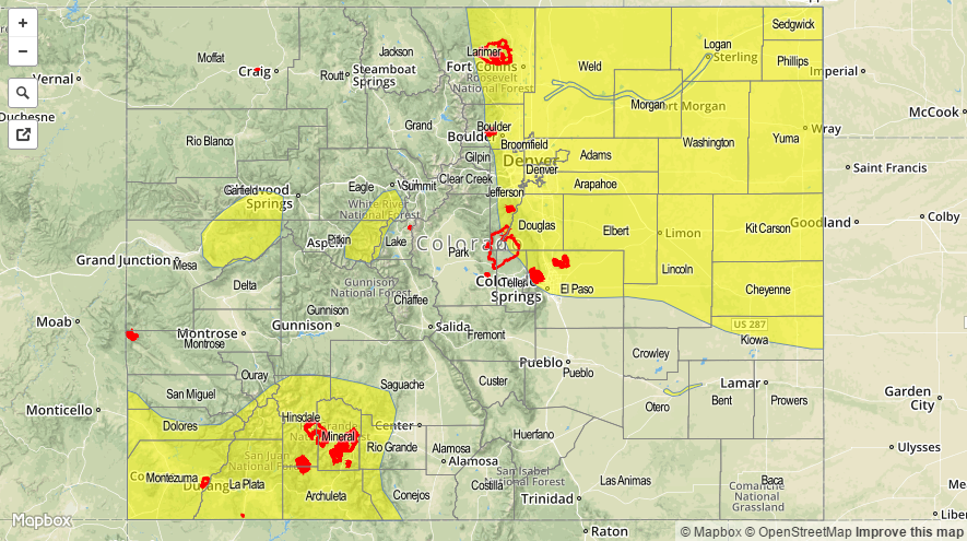
Today’s Flood Threat Map
For more information on today’s flood threat, see the map below (hover over threat areas for more details). For Zone-Specific forecasts, jump below the map.

Zone-Specific Forecasts
Front Range, Urban Corridor, Palmer Ridge, Northeast Plains, Southeast Plains, and Raton Ridge:
Scattered showers and thunderstorms expected this afternoon and evening, a few will become severe. Even though deep moisture has been lessened overall, the passing cool front has reinforced low-level moisture across the area. This will allow a few stronger storms to produce heavy rainfall, with maximum rain rates of 1.2-2.0 inches/hour. Storm motions will mitigate some of the flooding concern, but locations have received heavy rain over the last few days. Main concerns for flooding issues will be street flooding in urban areas, rising streams in low-lying areas, and burn scars. Field ponding will also be an issue under heavy rain due to saturated conditions.
Timing: 11 AM – 9 PM will be primetime, with showers and thunderstorms diminishing overnight from north to south.
Central Mountains, San Juan Mountains, San Luis Valley, Grand Valley, Southeast Mountains, Southwest Slope, Northern Mountains, and Northwest Slope:
Scattered showers and thunderstorms are expected this afternoon and evening, diminishing quickly just after sunset. With moisture less than yesterday, storms will be less efficient at producing heavy rainfall, though brief heavy rain will still be a threat with stronger thunderstorms. The main concern for flash flooding issues will be the San Juan Mountains and Southwest Slope regions for reasons described above. Additionally, with rising temperatures causing snowmelt, streams are already running a bit high and will likely respond quicker to any rainfall.
Maximum rain rates will not be particularly high at 0.4-0.8 inches/hour. Flash flooding concerns stem mainly from antecedent conditions.
Timing: 11 AM – 8 PM, quickly diminishing thereafter.