Issue Date: 6/22/2015
Issue Time: 9:20 AM
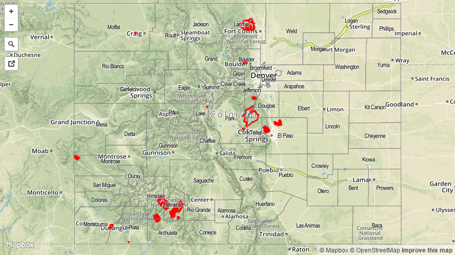
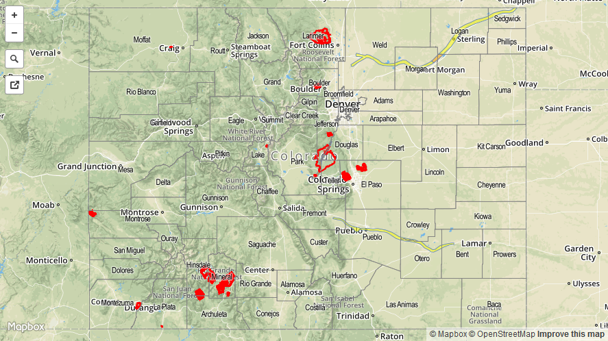
A MODERATE FLOOD THREAT CONTINUES FOR THE LEVEE BREACH ALONG THE SOUTH PLATTE RIVER IN MORGAN AND WASHINGTON COUNTIES, AS WELL AS ALONG THE SOUTH PLATTE RIVER ACROSS PORTIONS OF PARK, DOUGLAS, AND JEFFERSON COUNTIES. A MODERATE FLOOD THREAT IS IN PLACE FOR PORTIONS OF THE ARKANSAS RIVER AS SNOWMELT AND RESERVOIR RELEASES WILL KEEP RIVER LEVELS HIGH.
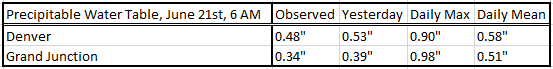
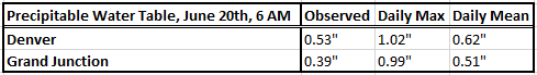
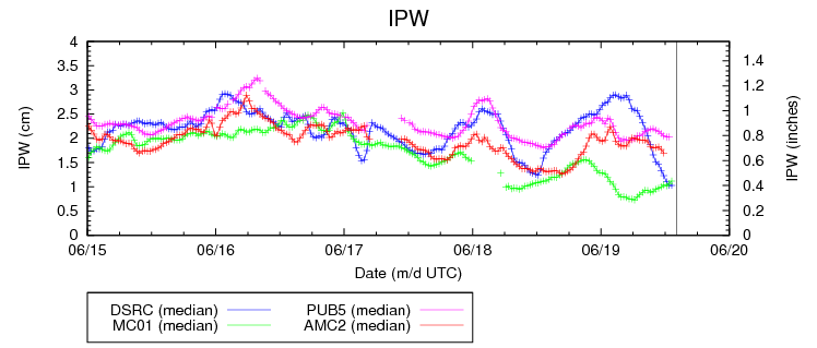
You will notice that today’s forecast mirrors much of the last few days’, with abundant sunshine and dry conditions in the forecast. Moisture has continued the overall downward trend over the last few days, easily seen in the IPW chart below. As of 8 AM, all four of the normal reporting stations – Boulder (blue), Grand Junction (green), Pueblo (pink), Shriever AFB (red) – were below 0.4 inches IPW. A cool front is currently cutting through eastern Colorado, reinforcing some moisture and bringing gusty, northerly winds. The main result from the front today will be slightly cooler high temperatures for the Urban Corridor, Northeast Plains, Palmer Ridge, and Southeast Plains regions. Over the mountains, temperatures will be nearly the same as yesterday, with the lowest valleys flirting with, and a few surpassing, 100 F for afternoon highs.
With the slight increase in low-level moisture and a bit of convergence along the frontal boundary, an isolated thunderstorm or two will be possible across southern Palmer Ridge, the Southeast Mountains, and Raton Ridge. The Southeast Plains near these preferred terrain zones will also hold the slim chance for an isolated thunderstorm late this afternoon and into the evening hours. With all of that said, however, warm air aloft is nearly identical to yesterday, and surface temperatures will be slightly cooler, meaning the cap will likely be tougher to break than yesterday. The difference lies in the front, and whether or not it can provide enough forcing for an isolated thunderstorm or two. At any rate, the main result will be locally gusty winds and lightning, with locally moderate rainfall. Maximum rain rates will be 0.6-1.2 inches/hour.
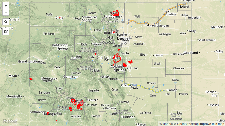
Today’s Flood Threat Map
For more information on today’s flood threat, see the map below (hover over threat areas for more details). For Zone-Specific forecasts, jump below the map.
Zone-Specific Forecasts
Front Range, Urban Corridor, Palmer Ridge, Southeast Plains, and Northeast Plains, Southeast Mountains, and Raton Ridge:
Mostly sunny and hot, with highs ranging from the 80s to upper 90s. An isolated, late afternoon/evening thunderstorm or two will be possible along the Southeast Mountains, Palmer Ridge, Raton Ridge, and adjacent portions of the Southeast Plains. Maximum rain rates will be 0.6-1.2 inches/hour, with the main threats being lightning and locally gusty winds.
Timing: 2 PM – 10 PM
After the low level jet kicks in late this evening, an isolated shower/weak thunderstorm will be possible (8 PM – Midnight) across the Northeast Plains. Heavy rain is not expected, as rain rates will be less than 0.5 inches/hour.
Northern Mountains, Northwest Slope, Central Mountains, Grand Valley, San Luis Valley, Southwest Slope, and San Juan Mountains:
Mostly sunny and hot, with temperatures much like yesterday. Highs in the lowest valleys will inch a bit higher than yesterday, pushing temperatures to near, or just above 100 F. Fire weather conditions continue across portions of the Northwest Slope, so be sure and check with NWS Grand Junction for more details if you plan on being in that region today.