Issue Date: 6/20/2015
Issue Time: 8:45 AM
A MODERATE FLOOD THREAT CONTINUES FOR PORTIONS OF THE SOUTH PLATTE RIVER. A LOW FLOOD THREAT CONTINUES FOR PORTIONS OF THE ARKANSAS RIVER, SOUTH PLATTE RIVER, AND CACHE LA POUDRE RIVER. ADDITIONALLY, VARIOUS STREAMS/RIVERS CONTINUE TO RUN HIGH ACROSS WESTERN COLORADO.
A phrase made famous by Buster Poindexter in 1987 describes the forecast well for today: “Hot Hot Hot.” The mercury will continue to climb into the upper 80s and mid 90s for many low elevation locations, and near 100 in the lower Arkansas River Valley and the lowest elevations of far western Colorado. If you plan on being outdoors today, be sure to pack the sunscreen, drink plenty of water, and take breaks out of the direct sunlight.
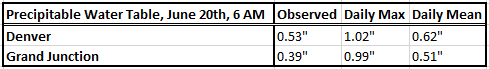
Similar to yesterday, a few isolated, high-based showers and weak thunderstorms will develop over the mountains, producing mainly gusty winds and lightning. Heavy rainfall will not be a threat from any storms over the higher elevations today. Locations to watch today for a stronger thunderstorm or two will be the Urban Corridor, Palmer Ridge, Northeast Plains, and Southeast Plains. IF a storm can develop in those regions (warm air aloft is still providing a stout cap that will be tough to break), it will have access to enough shear to bring locally severe wind gusts and small hail, but again, heavy rain will not be a threat today. The atmosphere is simply too dry, with precipitable water values below average statewide (see “Precipitable Water Table” above).
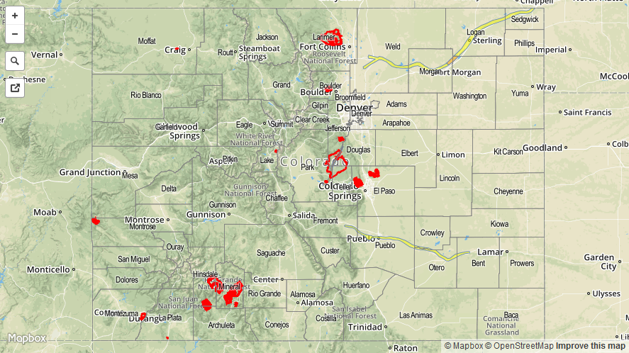
Today’s Flood Threat Map
For more information on today’s flood threat, see the map below (hover over threat areas for more details). For Zone-Specific forecasts, jump below the map.

Zone-Specific Forecasts
Front Range, Urban Corridor, Palmer Ridge, Southeast Plains, Northeast Plains and Raton Ridge:
Mostly sunny and hot, with highs ranging from the upper 80s to the upper 90s. A few locations across the lower Arkansas River Valley will flirt with 100. A couple isolated, high-based showers/thunderstorms will be possible, mainly over and near favored terrain, but heavy rain will not be a threat. Only IF storms can develop, will they have the potential to produce locally severe wind gusts and small hail. Maximum rain rates will be 0.2-0.4 inches/hour.
Timing: 3 PM – 9 PM
Central Mountains, San Juan Mountains, San Luis Valley, Grand Valley, Southeast Mountains, Southwest Slope, Northern Mountains, and Northwest Slope:
Mercury will continue to climb high today, pushing temperatures near 100 for the lowest elevations of far western Colorado. Other low elevations will be in the 80s and 90s, ranging into the 50s and 60s for higher mountain locations. A couple isolated showers/weak thunderstorms are possible over the San Juan Mountains, Central Mountains, and Southeast Mountain regions, but they will produce more wind and lightning than rain. Maximum rain rates will be less than 0.2 inches/hour.
Timing: 1 PM – 8 PM