Issue Date: 6/19/2015
Issue Time: 9:38 AM
A MODERATE FLOOD THREAT CONTINUES FOR THE SOUTH PLATTE RIVER AND CACHE LA POUDRE RIVER. A LOW FLOOD THREAT CONTINUES FOR PORTIONS OF THE ARKANSAS RIVER. ADDITIONALLY, VARIOUS STREAMS/RIVERS CONTINUE TO RUN HIGH ACROSS WESTERN COLORADO.
The big story in today’s forecast will be the heat, as temperatures continue to climb over yesterday’s highs, bringing many low elevations into the 80s and 90s, and near 100 for the lowest valleys of Western Colorado. As temperatures also climb in the mountains, snowmelt will continue and streams/rivers will continue to run high. If you plan on being outdoors today, be careful near any flowing bodies of water. Saturated soils have made many banks unstable. Check with the local National Weather Service office for up-to-date warnings/advisories for areas you plan to visit.
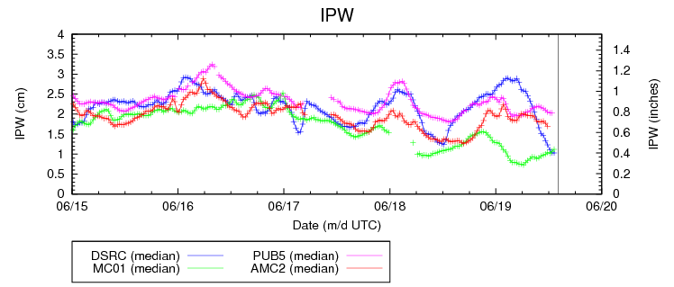
A few isolated, afternoon/evening showers and thunderstorms will be possible, mainly over the higher terrain. Under westerly flow aloft, a storm or two will drift off of the mountains and over lower elevations, but gusty winds will be the main result. As you can see in the IPW graph below, the atmosphere is very dry across Colorado, so light rain will be about all storms can muster. The best chance for any measurable rainfall will be south of Highway 50, where moisture is slightly better. Even so, rain rates south of Highway 50 will max out around 0.4-0.6 inches/hour.
One area to watch will be the far Southeast Plains (Baca, Las Animas, Bent, Prowers, Kiowa, and Cheyenne counties) late this afternoon through the evening hours, as a dryline will set itself up across the region, with higher dewpoints just to the east. This will allow decent instability to take shape, and a few isolated thunderstorms are possible along this boundary. Without much help from wind shear, storms will be of the pulse variety if they can develop, coming down nearly as quickly as they go up. Brief moderate-to-heavy rain will be possible under these storms, with maximum rain rates of 0.8-1.2 inches/hour.
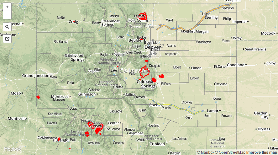
Today’s Flood Threat Map
For more information on today’s flood threat, see the map below (hover over threat areas for more details). For Zone-Specific forecasts, jump below the map.

Zone-Specific Forecasts
Front Range, Urban Corridor, Palmer Ridge, and Northeast Plains:
Mostly sunny and hot is the main story today. Isolated showers/weak thunderstorms are possible late this afternoon over the Front Range, and then drifting eastward over the other regions. The main impacts from activity will be locally gusty winds and lightning, as storms will only muster light rain. Rain rates will be 0.10-0.25 inches/hour.
Timing: 2 PM – 10 PM
Southeast Plains, and Raton Ridge:
Mostly sunny and hot, with temperatures climbing into the 90s. Lower locations in the Arkansas River valley will reach near 100. A few isolated showers and thunderstorms will develop this afternoon/evening, resulting in mainly gusty winds, lightning, and light rainfall. The strongest storms will be capable of producing rain in the 0.8-1.2 inches/hour range over the far Southeast Plains late this afternoon/evening.
Timing: 2 PM – Midnight
Central Mountains, San Juan Mountains, San Luis Valley, Grand Valley, Southeast Mountains, Southwest Slope, Northern Mountains, and Northwest Slope:
Isolated showers/weak thunderstorms over the San Juan Mountains, Southeast Mountains, and Central Mountains; it will be sunny and dry elsewhere. With the dry atmosphere, any activity will result in gusty winds and some lightning, with sprinkles/light rain to the tune of 0.10-0.25 inches/hour being the best they can produce.
Timing: Noon – 7 PM