Issue Date: 6/21/2015
Issue Time: 8:53 AM
A MODERATE FLOOD THREAT CONTINUES FOR PORTIONS OF THE SOUTH PLATTE RIVER. A LOW FLOOD THREAT CONTINUES FOR PORTIONS OF THE ARKANSAS RIVER, SOUTH PLATTE RIVER, AND CACHE LA POUDRE RIVER. ADDITIONALLY, VARIOUS STREAMS/RIVERS CONTINUE TO RUN HIGH ACROSS WESTERN COLORADO.
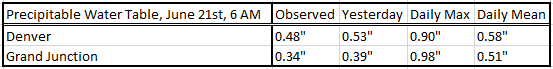
It appears that Mother Nature received the memo that today is the first official day of summer. True to form, the hottest temperatures of the year so far will be felt across many locations today as high pressure ridging continues to build across the southwestern US. Expect today to be much like yesterday, with the exception that the atmosphere has dried out a bit more (see “Precipitable Water Table” below). With warm air aloft, the decrease in moisture will mean that the already small chances of firing any thunderstorm activity have become even slimmer, and any storms that do form will not pose a heavy rain threat. For more specifics on areas that could see an isolated storm or two, please jump down to the Zone-Specific Forecasts below the threat map.
One note of importance in today’s forecast is the fire weather conditions that have returned to the northwestern corner of the state. Red Flag Warnings have been hoisted for portions of Moffat and Rio Blanco Counties due to gusty winds, low relative humidities, and dry fuels. If you plan on being in those areas today, stay up-to-date with changing conditions by checking in with NWS Grand Junction.
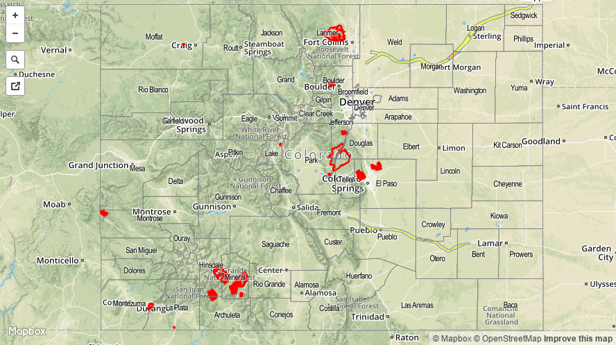
Today’s Flood Threat Map
For more information on today’s flood threat, see the map below (hover over threat areas for more details). For Zone-Specific forecasts, jump below the map.

Zone-Specific Forecasts
Front Range, Urban Corridor, Palmer Ridge, Southeast Plains, Northeast Plains and Raton Ridge:
Mostly sunny skies and hot temperatures will be the main story again today, with temperatures nudging up from yesterday’s highs. High temperatures will be in the low-to-mid 90s for many locations, reaching into the low 100s for some locations in the Southeastern Plains. An isolated storm or two will be possible in the Palmer Ridge, Raton Ridge, Northeastern Plains, and Southeastern Plains regions, though the likelihood is very slim. With temperatures climbing as high as they are forecast, plenty of instability will be available if, and only if, the cap of warm air aloft can be broken through. No heavy rain is expected, as the atmosphere is much too dry, but locally gusty winds and lightning will be the main threats. Maximum rain rates will be 0.2-0.4 inches/hour.
Timing: 1 PM – 8 PM
Central Mountains, San Juan Mountains, San Luis Valley, Grand Valley, Southeast Mountains, Southwest Slope, Northern Mountains, and Northwest Slope:
Mostly sunny and hot, with only a slim chance of an isolated weak shower/thunderstorm or two over the San Juan Mountains and Southeast Mountains. Any activity will be high-based, so no more than a sprinkle is expected. Red Flag Warnings have been issued for portions of the Northwest Slope, so be sure to check with NWS Grand Junction for more details.
Timing: 1 PM – 7 PM