FTB 07-20-2015: Low-to-Moderate Flood Threat as Subtropical Moisture Remains

Issue Date: 7/20/2015
Issue Time: 10:07 AM

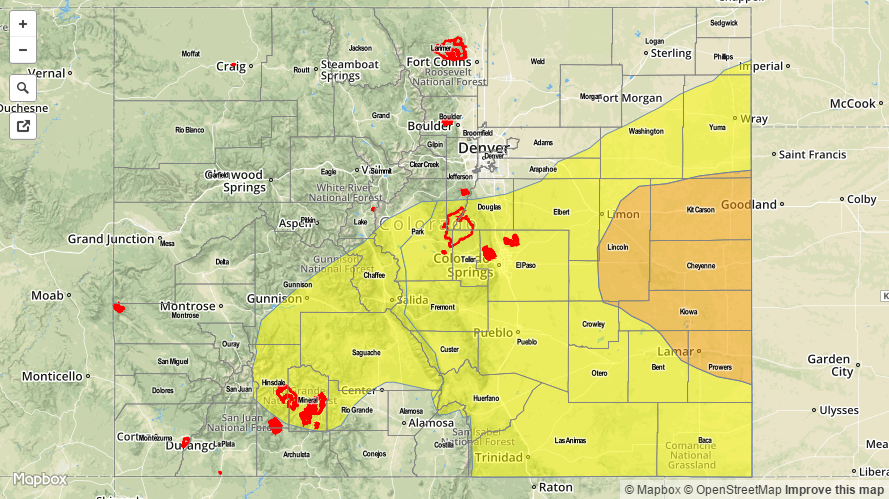
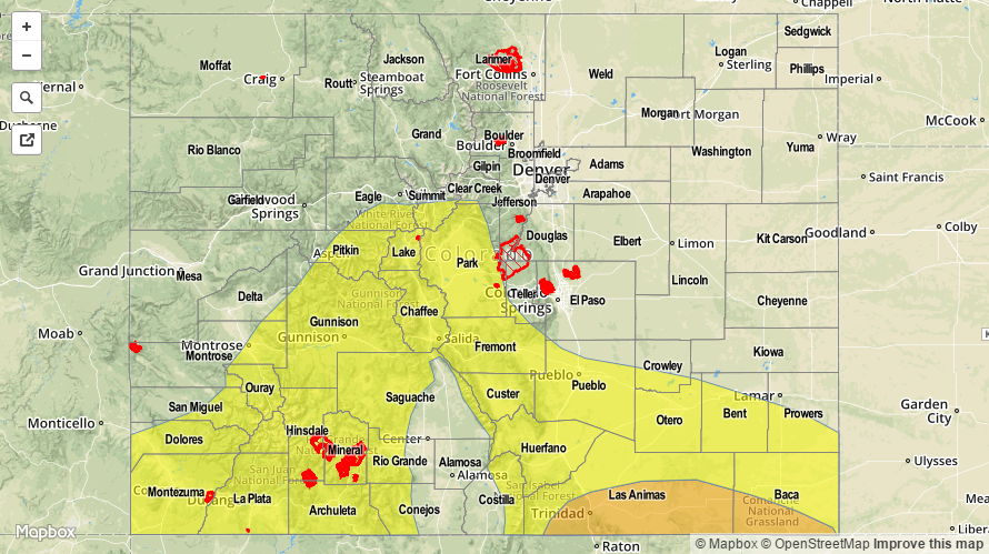
A MODERATE FLOOD THREAT IS ISSUED FOR PORTIONS OF THE RATON RIDGE AND SOUTHEAST PLAINS.

A LOW FLOOD THREAT IS ISSUED FOR PORTIONS OF THE CENTRAL MOUNTAINS, SAN JUAN MOUNTAINS, SOUTHWEST SLOPE, FRONT RANGE, SOUTHEAST MOUNTAINS, RATON RIDGE, AND SOUTHEAST PLAINS.

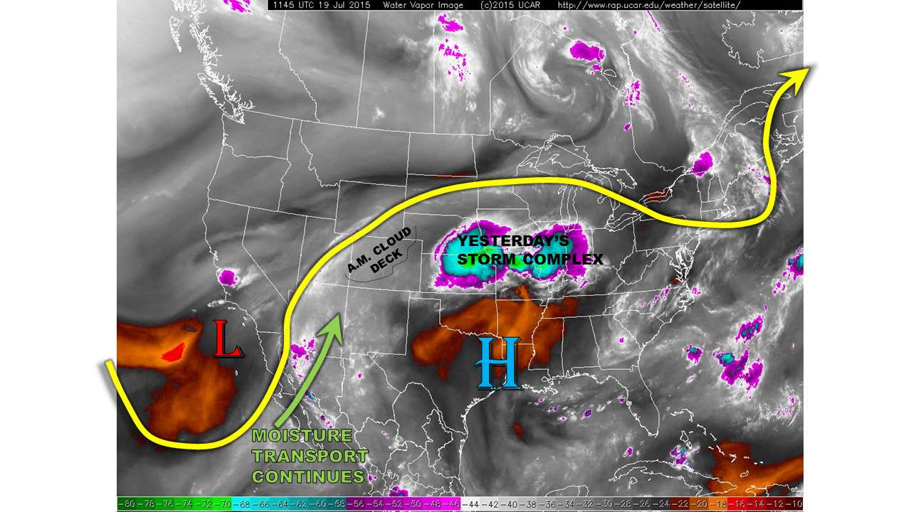
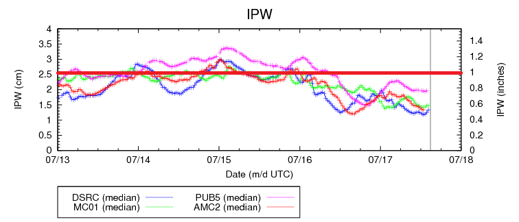
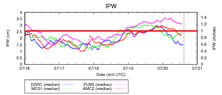
Colorado remains under the influence of mid-level subtropical moisture as the high pressure ridge remains in a favorable position over the south-central US. For locations experiencing greater surface moisture the result is higher precipitable water values. Low-level moisture decreases, on average, from south to north, and this is easily seen in the IPW graph below; Pueblo currently sits at 1.2 inches, Colorado Springs and Grand Junction between 0.8 and 1.0 inch, and Boulder around 0.6 inches. This deeper moisture is important when it comes to today’s thunderstorm chances and subsequent flood threat.

IPW_07202015

The mountains will experience the best coverage of showers and thunderstorms today, especially along and south of I-70, as orographic influences combine with daytime heating and make use of the subtropical moisture available. Locally heavy rainfall will be possible, but storm motions will help limit the flood threat somewhat. An influx of moisture from the southwest will occur overnight, likely keeping showers and a thunderstorm or two around through tomorrow morning.

For areas east of the mountains, the probability of thunderstorms decreases from west to east. The Urban Corridor and Palmer Ridge will hold the chance for isolated weak thunderstorms this afternoon and evening, but they will rely on outflow boundaries from mountain convection to develop. The Northeast Plains will stay dry, except for a stray weak shower/thunderstorm near the Urban Corridor, as the environment will stay capped due to weak subsidence, warm mid-level temperatures and drying low-levels. The most active locations east of the mountains will be the Raton Ridge and southern extents of the Southeast Plains, thanks to more available moisture and the presence of a weak surface boundary that will stall near the CO/NM border. Scattered thunderstorms will be likely across the Raton Ridge near the interface with the Southeast Mountains, with more isolated activity across the remainder of the Raton Ridge and the Southeast Plains.

Today’s Flood Threat Map

For more information on today’s flood threat, see the map below (hover over threat areas for more details). For Zone-Specific forecasts, jump below the map.

20150720_MFT
Flood Threat Legend

Zone-Specific Forecasts

Urban Corridor, Palmer Ridge, and Northeast Plains:

Mostly sunny and warm will be the main story today, with only a couple isolated, weak showers/thunderstorms possible this afternoon and evening, with the best relative chance across the Urban Corridor. Flooding issues are not expected as storm motions and low-to-moderate rain rates will not be enough to warrant concern. Maximum rain rates will be 0.4-1.0 inches/hour.

Timing: 1 PM – 9 PM, with one or two showers/thunderstorms possible through 1 AM thanks to outflow boundaries from mountain convection.

Southeast Plains and Raton Ridge:

Mostly sunny and dry for most, with scattered showers and thunderstorms south of Highway 50, near the interface with the Southeast Mountains, becoming more isolated to the east. Maximum rain rates will be 1.2-2.0 inches/hour.

Timing: 1 PM – Midnight, with a few scattered showers/thunderstorms continuing into tomorrow morning as moisture increases from the southwest with the arrival of the next disturbance.

Front Range, Northern Mountains, Northwest Slope, Grand Valley, Central Mountains, Southeast Mountains, San Luis Valley, Southwest Slope, and San Juan Mountains:

Partly sunny with temperatures slightly below average will be the name of the game today as isolated showers and weak thunderstorms are expected north of I-70, becoming scattered/more numerous south of I-70. The further south, the deeper the moisture will be, and thus, the higher the maximum rain rates. Let’s break it down:

Northern Mountains, Northwest Slope, and Grand Valley: 0.4-0.8 inches/hour
Central Mountains and Front Range: 0.6-1.1 inches/hour
San Juan Mountains, Southwest Slope, San Juan Valley, and Southeast Mountains: 0.8-1.4 inches/hour

Timing: 11 AM – 8 PM, with ongoing showers and thunderstorms expected into tomorrow morning for southern zones (Southwest Slope, San Juan Mountains, and San Luis Valley) as moisture increases from the south/southwest with the arrival of the next disturbance.

FTB 07-19-2015: Very Heavy Rainfall Possible Over Eastern Colorado

Issue Date: 7/19/2015
Issue Time: 10:10AM

— Moderate flood threat for Palmer Divide and Southeast Plains
— Low flood threat for Northeast Plains, San Juans, Raton Ridge and Southeast Mountains

Moisture has substantially increased over all of Colorado in the last 24 hours. This is courtesy of the remnants of Hurricane Dolores, which is currently spinning just off the southern California coast (see water vapor image below). Certainly a rarity. Precipitable water values (PW) climbed from the 0.6 – 0.8 range yesterday into the 1.0 – 1.3 inch range this morning. These values are very high, and certainly support a heavy rainfall threat. However, not all ingredients are supportive of heavy rain today. A thick cloud deck this morning across western and central parts of the state will limit solar heating, and thus, atmospheric instability. However, the southeast quadrant of the state is mostly cloud free, which is where most of today’s action will be. This will also be aided by a weak front that is expected to develop along and south of the Palmer Ridge, courtesy of the diurnal lee-side low pressure circulation.

watervapor_20150719

For today, we expect mostly cloudy skies to continue over and west of the Continental Divide. Meanwhile, sunny skies will lead to scattered thunderstorms over the Palmer Ridge and stretching southwestward into the San Juans. A Low flood threat is in place for these regions. Farther east, towards the Kansas border, storms will intensify by early evening, paving the way for a very heavy rainfall threat. A Moderate threat is in place for this region.

Today’s Flood Threat Map

For more information on today’s flood threat, see the map below (hover over threat areas for more details). For Zone-Specific forecasts, jump below the map.

20150719_LFT
Flood Threat Legend

Zone-Specific Forecasts

Southeast Plains, Northeast Plains, Palmer Ridge, Front Range, Urban Corridor, Raton Ridge, Southeast Mountains:

Partly cloudy early with isolated to scattered thunderstorms forming by early afternoon and lasting until as late as 1AM in the far east. Highest coverage will be over the higher terrain south of I-70, and the Southeast Plains. Maximum 1-hr rain rates up to 1.8 inches will be possible, especially south. However, rain rates may reach 2.5 inches per hour in the eastern Southeast Plains. Gusty winds up to 60 mph and hail up to 1.25 inch may accompany the stronger cells. A Moderate flood threat is in place today.

Primetime: 2PM to 1AM

Southwest Slope, San Juans, Grand Valley, San Luis Valley:

Partly to mostly cloudy early with scattered rain showers turning into thunderstorms by early afternoon. One-hour rain rates up to 1.0 inch will be possible, with flash flooding, debris slides and mud flows possible. A Low flood threat is in place. Storms will diminish shortly after sunset

Primetime: Noon to 8PM

Northwest Slope, Northern Mountains, Central Mountains:

Mostly cloudy early with scattered showers, turning into weak thunderstorms by early afternoon. One hour rain rates up to 0.6 inches will be possible, along with gusty winds up to 50 mph. Activity will quickly subside by sunset. No flooding is expected today.

FTB 07-18-2015: Break Is Over As Heavy Rain Threat Returns To Colorado

Issue Date: 7/18/2015
Issue Time: 10:05AM

— Moderate flood threat for Northeast Plains
— Low flood threat for Southwest Slope, San Juans and Grand Valley

After a few days off from the heavy rain, the active summer is back in action today over Colorado. The water vapor image, below, shows a busy weather map over the western United States. Almost all of the attention has gone to recently downgraded Tropical Storm Dolores, found to the southwest of Baja California. Although Dolores is no longer producing strong winds, it has an impressive feed off moisture being transported into the Southwest U.S. Meanwhile, another set of disturbances is also found north and west of Colorado. These features will slowly approach the state and provide dynamics that will favor a heavy rain threat, both east and west of the Divide.

watervapor_20150718

Though precipitable water (PW) values are currently in the 0.6 to 0.8 inch range, as shown below, we expect these to increase. By early evening, PWs will get close to 1 inch over Southwest Colorado, and up to 1.3 inches in the far northeast.

IPW_20150718

For today, we expect mostly sunny skies early, with thunderstorm activity forming by noon across the higher terrain. Storms will then spread east, with additional redevelopment likely near the WY/CO border of the Northeast Plains. West of the Divide, expect increasing moisture to lead to locally heavy thunderstorms, with 1-hr rain rates up to 0.9 inches per hour. A Low flood threat is in place for parts of the region. East of the Divide, an organization of late afternoon storm activity will also lead to a very heavy rainfall threat in the Northeast Plains. A Moderate flood threat is in place there.

We expect another active day tomorrow (Sunday) as the combination of subtropical moisture and dynamics from the north continue to impact parts of Colorado.

Today’s Flood Threat Map

For more information on today’s flood threat, see the map below (hover over threat areas for more details). For Zone-Specific forecasts, jump below the map.
FTB_snapshot_20150718

Zone-Specific Forecasts

Northeast Plains:

Sunny early, with increasing clouds and scattered thunderstorms by 3PM. Storm coverage and intensity is expected to increase by early evening. One hour rain rates up to 2.8 inches will be possible near the NE/KS border, with lower values to the west. Scattered strong storms may continue until 1AM. Gusty winds will also be possible, up to 65 mph. A Moderate flood threat is in place.

Primetime: 3PM to 1AM

Southeast Plains, Palmer Ridge, Front Range, Urban Corridor, Raton Ridge, Southeast Mountains:

Mostly sunny early with isolated to scattered thunderstorms forming by early afternoon. Highest coverage will be over the higher terrain, as well as the Front Range/Urban Corridor near the Wyoming border. Maximum 1-hr rain rates up to 0.8 inches will be possible (highest values farther east), along with gusty winds up to 60mph. No flooding is expected today.

Southwest Slope, San Juans, Grand Valley:

Partly to mostly cloudy early with scattered rain showers turning into thunderstorms by early afternoon. One-hour rain rates up to 0.9 inches will be possible, with flash flooding, debris slides and mud flows possible. A Low flood threat is in place. Isolated storms may be possible through 11PM, as moisture continues to increase.

Primetime: Noon to 11PM

Northwest Slope, Northern Mountains, Central Mountains, San Luis Valley:

Mostly sunny early, then turning partly cloudy. Isolated to widely scattered thunderstorms will form over the higher terrain and last from early afternoon to around sunset. Max 1-hr rain rates up to 0.4 inches will be possible, along with gusty winds up to 55 mph. No flooding is expected today.

FTB 07-17-2015: Mostly Sunny and Hot with Isolated Thunderstorms

Issue Date: 7/17/2015
Issue Time: 9:20 AM

NO FLOOD THREAT IS FORECAST.

Today will feel a lot like summertime in Colorado, as abundant sunshine will give way to rising temperatures this afternoon, reaching highs around, or just above, average for this time of year. The drying atmosphere over the past 2 days is easily seen in the precipitable water graph below. On Wednesday, IPW values maximized around 1-1.2 inches statewide, and as of this morning, those values have dipped down to 0.4-0.8 inches. This will provide enough moisture for afternoon and evening high-based thunderstorms, but not enough moisture to produce a flood threat. Instead, the biggest impact from storms will be lightning and gusty winds, with some brief light-to-moderate rainfall.

IPW_07172015

Most of the activity will occur over the higher terrain, where orographic effects will combine with daytime heating to generate isolated-to-widely scattered thunderstorms. Over the lower elevations of eastern Colorado, isolated thunderstorms are possible, generally resulting in gusty winds and lightning, but very little rainfall. Near the CO/KS border, there is potential for one or two strong-to-severe thunderstorms to develop along a weak surface convergence zone. These stronger storms will produce brief bouts with moderate rainfall, but strong winds gusting up to 60-70 mph will be the main threat.

Today’s Flood Threat Map

For more information on today’s flood threat, see the map below (hover over threat areas for more details). For Zone-Specific forecasts, jump below the map.
NoFloodThreat

Zone-Specific Forecasts

Urban Corridor, Palmer Ridge, Southeast Plains, Northeast Plains, and Raton Ridge:

Isolated afternoon and evening high-based thunderstorms are expected to break up the otherwise sunny skies. For most areas, they will result in mainly gusty winds and lightning, accompanied with brief light-to-moderate rainfall. Near the CO/KS border, as mentioned above, one or two strong-to-severe thunderstorms are possible, with the main threats being cloud-to-ground lightning and strong winds. Maximum rain rates near the CO/KS border will be 0.4-0.8 inches/hour, with everywhere else sitting 0.15-0.30 inches/hour.

Timing: 2 PM – 9 PM

Front Range, Northern Mountains, Northwest Slope, Grand Valley, Central Mountains, Southeast Mountains, San Luis Valley, Southwest Slope, and San Juan Mountains:

Mostly sunny and hot for most, with isolated-to-widely scattered thunderstorms expected over the higher terrain. Heavy rain is not expected; storms will be high-based, resulting in gusty winds and lightning being the main impacts. Maximum rain rates will be 0.25-0.45 inches/hour, with most areas receiving less than 0.1 inches of total rainfall.

Tomorrow morning, southern areas will likely see an uptick in shower activity as the next moisture surge begins to arrive from the southwest. Additionally, as the upper-level trough becomes centered over the northern Rockies, northern zones will see an uptick in shower activity during the morning hours as a bit more moisture is pushed in from the west/northwest.

Timing: Noon – 8 PM, with an uptick in shower activity, as mentioned above, beginning after midnight.