Issue Date: 7/18/2015
Issue Time: 10:05AM
— Moderate flood threat for Northeast Plains
— Low flood threat for Southwest Slope, San Juans and Grand Valley
After a few days off from the heavy rain, the active summer is back in action today over Colorado. The water vapor image, below, shows a busy weather map over the western United States. Almost all of the attention has gone to recently downgraded Tropical Storm Dolores, found to the southwest of Baja California. Although Dolores is no longer producing strong winds, it has an impressive feed off moisture being transported into the Southwest U.S. Meanwhile, another set of disturbances is also found north and west of Colorado. These features will slowly approach the state and provide dynamics that will favor a heavy rain threat, both east and west of the Divide.
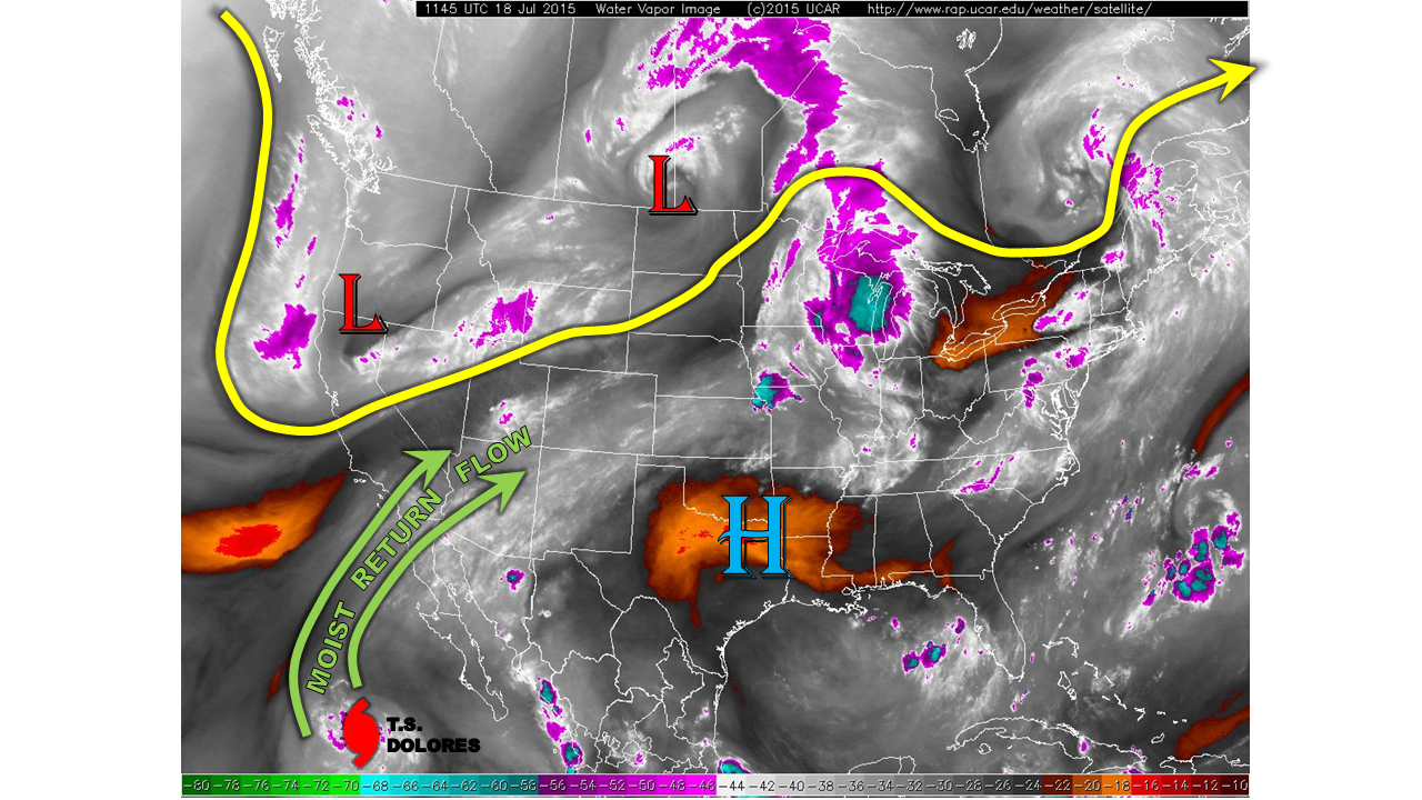
Though precipitable water (PW) values are currently in the 0.6 to 0.8 inch range, as shown below, we expect these to increase. By early evening, PWs will get close to 1 inch over Southwest Colorado, and up to 1.3 inches in the far northeast.

For today, we expect mostly sunny skies early, with thunderstorm activity forming by noon across the higher terrain. Storms will then spread east, with additional redevelopment likely near the WY/CO border of the Northeast Plains. West of the Divide, expect increasing moisture to lead to locally heavy thunderstorms, with 1-hr rain rates up to 0.9 inches per hour. A Low flood threat is in place for parts of the region. East of the Divide, an organization of late afternoon storm activity will also lead to a very heavy rainfall threat in the Northeast Plains. A Moderate flood threat is in place there.
We expect another active day tomorrow (Sunday) as the combination of subtropical moisture and dynamics from the north continue to impact parts of Colorado.
Today’s Flood Threat Map
For more information on today’s flood threat, see the map below (hover over threat areas for more details). For Zone-Specific forecasts, jump below the map.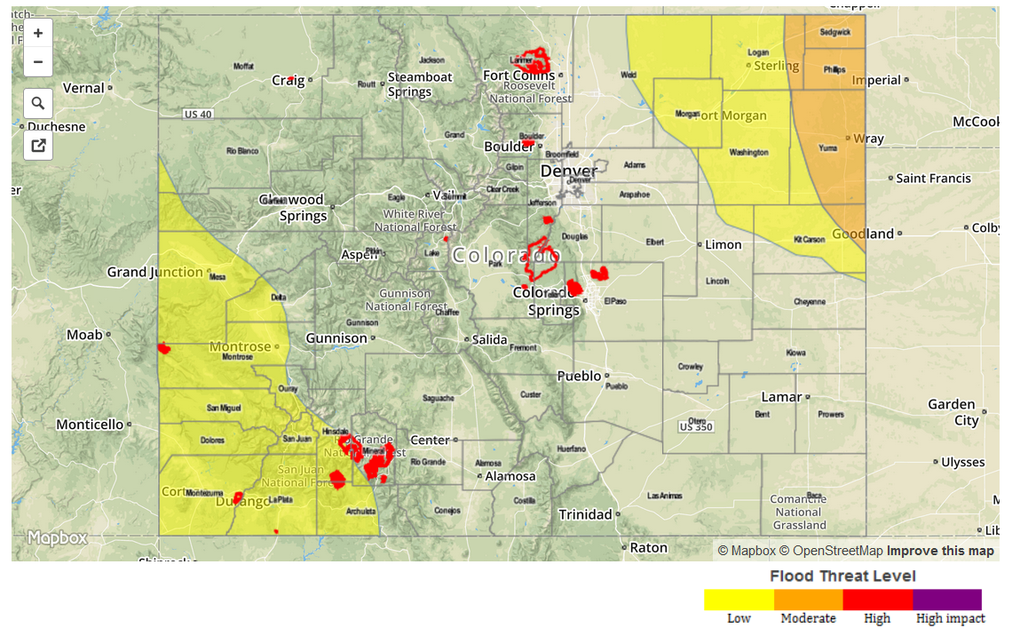
Zone-Specific Forecasts
Northeast Plains:
Sunny early, with increasing clouds and scattered thunderstorms by 3PM. Storm coverage and intensity is expected to increase by early evening. One hour rain rates up to 2.8 inches will be possible near the NE/KS border, with lower values to the west. Scattered strong storms may continue until 1AM. Gusty winds will also be possible, up to 65 mph. A Moderate flood threat is in place.
Primetime: 3PM to 1AM
Southeast Plains, Palmer Ridge, Front Range, Urban Corridor, Raton Ridge, Southeast Mountains:
Mostly sunny early with isolated to scattered thunderstorms forming by early afternoon. Highest coverage will be over the higher terrain, as well as the Front Range/Urban Corridor near the Wyoming border. Maximum 1-hr rain rates up to 0.8 inches will be possible (highest values farther east), along with gusty winds up to 60mph. No flooding is expected today.
Southwest Slope, San Juans, Grand Valley:
Partly to mostly cloudy early with scattered rain showers turning into thunderstorms by early afternoon. One-hour rain rates up to 0.9 inches will be possible, with flash flooding, debris slides and mud flows possible. A Low flood threat is in place. Isolated storms may be possible through 11PM, as moisture continues to increase.
Primetime: Noon to 11PM
Northwest Slope, Northern Mountains, Central Mountains, San Luis Valley:
Mostly sunny early, then turning partly cloudy. Isolated to widely scattered thunderstorms will form over the higher terrain and last from early afternoon to around sunset. Max 1-hr rain rates up to 0.4 inches will be possible, along with gusty winds up to 55 mph. No flooding is expected today.