Issue Date: 7/17/2015
Issue Time: 9:20 AM
NO FLOOD THREAT IS FORECAST.
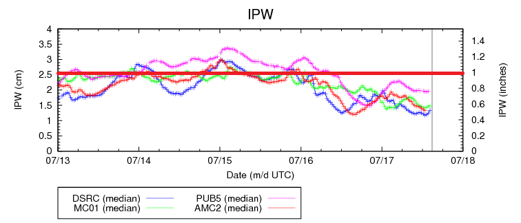
Today will feel a lot like summertime in Colorado, as abundant sunshine will give way to rising temperatures this afternoon, reaching highs around, or just above, average for this time of year. The drying atmosphere over the past 2 days is easily seen in the precipitable water graph below. On Wednesday, IPW values maximized around 1-1.2 inches statewide, and as of this morning, those values have dipped down to 0.4-0.8 inches. This will provide enough moisture for afternoon and evening high-based thunderstorms, but not enough moisture to produce a flood threat. Instead, the biggest impact from storms will be lightning and gusty winds, with some brief light-to-moderate rainfall.
Most of the activity will occur over the higher terrain, where orographic effects will combine with daytime heating to generate isolated-to-widely scattered thunderstorms. Over the lower elevations of eastern Colorado, isolated thunderstorms are possible, generally resulting in gusty winds and lightning, but very little rainfall. Near the CO/KS border, there is potential for one or two strong-to-severe thunderstorms to develop along a weak surface convergence zone. These stronger storms will produce brief bouts with moderate rainfall, but strong winds gusting up to 60-70 mph will be the main threat.
Today’s Flood Threat Map
For more information on today’s flood threat, see the map below (hover over threat areas for more details). For Zone-Specific forecasts, jump below the map.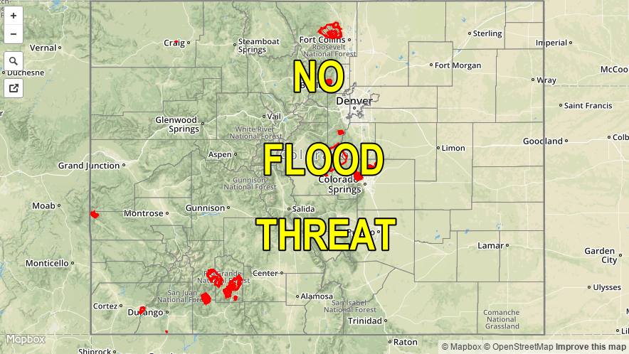
Zone-Specific Forecasts
Urban Corridor, Palmer Ridge, Southeast Plains, Northeast Plains, and Raton Ridge:
Isolated afternoon and evening high-based thunderstorms are expected to break up the otherwise sunny skies. For most areas, they will result in mainly gusty winds and lightning, accompanied with brief light-to-moderate rainfall. Near the CO/KS border, as mentioned above, one or two strong-to-severe thunderstorms are possible, with the main threats being cloud-to-ground lightning and strong winds. Maximum rain rates near the CO/KS border will be 0.4-0.8 inches/hour, with everywhere else sitting 0.15-0.30 inches/hour.
Timing: 2 PM – 9 PM
Front Range, Northern Mountains, Northwest Slope, Grand Valley, Central Mountains, Southeast Mountains, San Luis Valley, Southwest Slope, and San Juan Mountains:
Mostly sunny and hot for most, with isolated-to-widely scattered thunderstorms expected over the higher terrain. Heavy rain is not expected; storms will be high-based, resulting in gusty winds and lightning being the main impacts. Maximum rain rates will be 0.25-0.45 inches/hour, with most areas receiving less than 0.1 inches of total rainfall.
Tomorrow morning, southern areas will likely see an uptick in shower activity as the next moisture surge begins to arrive from the southwest. Additionally, as the upper-level trough becomes centered over the northern Rockies, northern zones will see an uptick in shower activity during the morning hours as a bit more moisture is pushed in from the west/northwest.
Timing: Noon – 8 PM, with an uptick in shower activity, as mentioned above, beginning after midnight.