Issue Date: 7/19/2015
Issue Time: 10:10AM
— Moderate flood threat for Palmer Divide and Southeast Plains
— Low flood threat for Northeast Plains, San Juans, Raton Ridge and Southeast Mountains
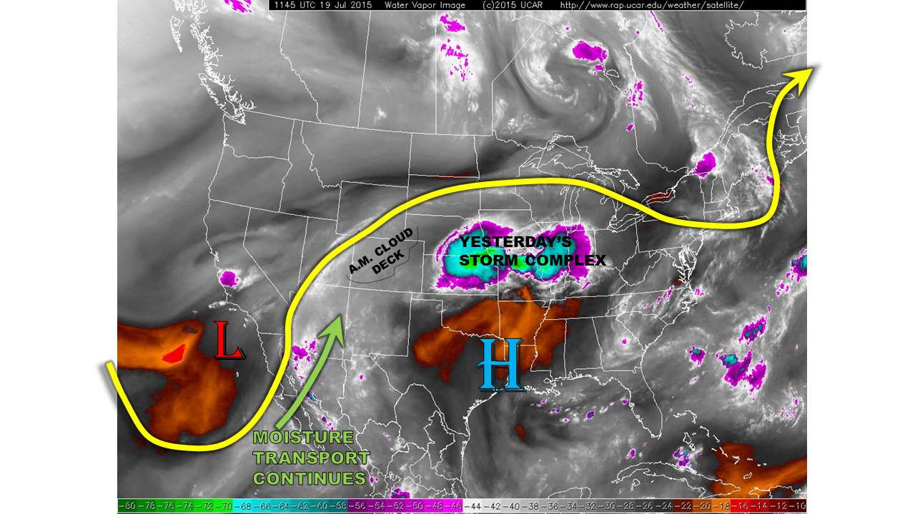
Moisture has substantially increased over all of Colorado in the last 24 hours. This is courtesy of the remnants of Hurricane Dolores, which is currently spinning just off the southern California coast (see water vapor image below). Certainly a rarity. Precipitable water values (PW) climbed from the 0.6 – 0.8 range yesterday into the 1.0 – 1.3 inch range this morning. These values are very high, and certainly support a heavy rainfall threat. However, not all ingredients are supportive of heavy rain today. A thick cloud deck this morning across western and central parts of the state will limit solar heating, and thus, atmospheric instability. However, the southeast quadrant of the state is mostly cloud free, which is where most of today’s action will be. This will also be aided by a weak front that is expected to develop along and south of the Palmer Ridge, courtesy of the diurnal lee-side low pressure circulation.
For today, we expect mostly cloudy skies to continue over and west of the Continental Divide. Meanwhile, sunny skies will lead to scattered thunderstorms over the Palmer Ridge and stretching southwestward into the San Juans. A Low flood threat is in place for these regions. Farther east, towards the Kansas border, storms will intensify by early evening, paving the way for a very heavy rainfall threat. A Moderate threat is in place for this region.
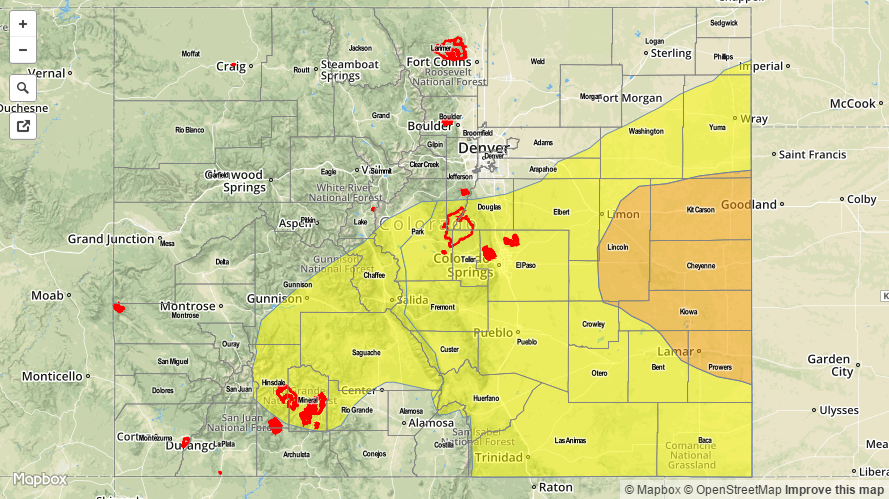
Today’s Flood Threat Map
For more information on today’s flood threat, see the map below (hover over threat areas for more details). For Zone-Specific forecasts, jump below the map.

Zone-Specific Forecasts
Southeast Plains, Northeast Plains, Palmer Ridge, Front Range, Urban Corridor, Raton Ridge, Southeast Mountains:
Partly cloudy early with isolated to scattered thunderstorms forming by early afternoon and lasting until as late as 1AM in the far east. Highest coverage will be over the higher terrain south of I-70, and the Southeast Plains. Maximum 1-hr rain rates up to 1.8 inches will be possible, especially south. However, rain rates may reach 2.5 inches per hour in the eastern Southeast Plains. Gusty winds up to 60 mph and hail up to 1.25 inch may accompany the stronger cells. A Moderate flood threat is in place today.
Primetime: 2PM to 1AM
Southwest Slope, San Juans, Grand Valley, San Luis Valley:
Partly to mostly cloudy early with scattered rain showers turning into thunderstorms by early afternoon. One-hour rain rates up to 1.0 inch will be possible, with flash flooding, debris slides and mud flows possible. A Low flood threat is in place. Storms will diminish shortly after sunset
Primetime: Noon to 8PM
Northwest Slope, Northern Mountains, Central Mountains:
Mostly cloudy early with scattered showers, turning into weak thunderstorms by early afternoon. One hour rain rates up to 0.6 inches will be possible, along with gusty winds up to 50 mph. Activity will quickly subside by sunset. No flooding is expected today.