FTB 05-08-2016: Unsettled Again, Brief Heavy Rain Possible

Issue Date: 5/8/2016
Issue Time: 9:10 AM

LOW FLOOD THREAT ISSUED FOR PORTIONS OF THE FRONT RANGE, URBAN CORRIDOR, SOUTHEAST PLAINS, NORTHEAST PLAINS, AND PALMER RIDGE.

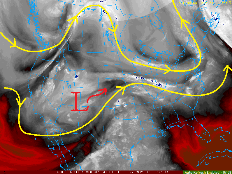
Unsettled weather is expected across much of the state today as the upper-level low shifts overhead. Thanks to the low being cutoff between the split streams in the atmospheric flow pattern (two yellow lines), its movement to the northeast has been slow. The core of the upper low will move overhead today, and the associated cold air aloft will steepen lapse rates and allow for another day of showers/thunderstorms across much of Colorado.

WV_20160508

In general, most areas will be less unstable than yesterday, especially over much of the High Country. As a result, storm coverage will be less and maximum rain rates will be lower. Areas from the Continental Divide and to the east will be the exception as instability will be higher, allowing stronger storms to produce moderate-to-heavy rainfall.

Far eastern Colorado will be the area to watch for a few strong-to-marginally severe storms. Instability will be higher here than any other locations across Colorado. The main threats from any severe storms will be hail (up to 1.5 inches in diameter), gusty winds (greater than 60 mph), and brief heavy rain. For more details, please see the region-specific forecast discussions below.

Today’s Flood Threat Map

For more information on today’s flood threat, see the map below (hover over threat areas for more details). For Zone-Specific forecasts, jump below the map.

Flood Threat Legend

Zone-Specific Forecasts

Urban Corridor, Palmer Ridge, Northeast Plains, Raton Ridge and Southeast Plains:

Scattered showers and thunderstorms expected this afternoon and evening, perhaps as early as 11 AM for western extents of the area. Most activity will be responsible for gusty winds, light-to-moderate rainfall, and lightning, while the stronger storms will be capable of brief heavy rain, small hail, and wind gusts over 40 mph. A few severe storms are expected, mainly near the CO/KS border. The main impacts from severe storms will be hail (up to 1.5 inches in diameter), damaging wind gusts (greater than 60 mph), lightning, and brief heavy rainfall.

Storm coverage will be highest over the Northeast Plains, with the least coverage expected over the Raton Ridge and far Southeast Plains.

Rain rates will generally be 0.3-0.7 inches/hour, with maximum rain rates of 1.2-1.8 inches/hour possible. A low flood threat has been issued.

Timing: 11 AM – 9 PM

Front Range, Northwest Slope, Northern Mountains, and Central Mountains:

Scattered showers and thunderstorms expected to begin late this morning, increasing in coverage through the afternoon, and continuing through the evening hours. A few showers will linger into the early morning hours.

Generally speaking, rain rates will be 0.2-0.4 inches/hour. Over the Front Range, thunderstorms will have enough moisture/instability to work with to produce rain rates up to 0.8-1.0 inches/hour. After yesterday’s moderate rainfall across northern portions of the Front Range, a low-end, low flood threat is warranted.

Timing: 11 AM – 9 PM, with a few showers lingering into tomorrow morning

Grand Valley, San Juan Mountains, Southwest Slope, San Luis Valley and Southeast Mountains:

Scattered showers are ongoing this morning across portions of the area, and will increase in coverage later this morning. A few weak thunderstorms will join the scattered showers this afternoon and evening, before much of the activity diminishing with sunset. A couple showers will linger into the early morning hours tomorrow across the higher terrain.

Rain rates will generally be light at 0.15-0.25 inches/hour, with thunderstorms maxing out rain rates at 0.2-0.4 inches/hour.

Timing: Ongoing – 9 PM, with lingering showers overnight and into tomorrow morning

FTB 05-07-2016: Another Day of Unsettled Weather, Severe Storms Possible

Issue Date: 5/7/2016
Issue Time: 9:30 AM

A LOW FLOOD THREAT IS FORECAST FOR PORTIONS OF THE NORTHERN MOUNTAINS, FRONT RANGE, URBAN CORRIDOR, AND NORTHEAST PLAINS.

The upper-level low will continue its slow progression to the east-northeast, leading to another day of unsettled weather across much of the state. The Southeast Plains and Raton Ridge will be largely left out of the action, with only isolated storm chances along/near the mountains and along the CO/KS border. For the rest of the state, scattered showers and thunderstorms are expected this afternoon/evening, with a few continuing overnight across the Northeast Plains.

Over much of the High Country, the showers/thunderstorms can be categorized as fairly garden variety. The exceptions to this rule will be across the Northern Mountains, Front Range, Northwest Slope and Central Mountains regions. In those regions, especially the Northern Mountains and Front Range, strong-to-severe storms will be possible. Moderate-to-heavy rainfall will be possible with the strongest storms, thanks to precipitable water values in the 90th percentile for the date; hence the inclusion in the low flood threat area.

IPW_20160507

The main area of focus for today’s flood threat includes the Front Range (for reasons stated above), Urban Corridor, and Northeast Plains. A leeside surface low/trough has developed in response to the upper-level forcing, which will provide reinforcement of moisture into the area with east/northeast surface flow. In addition, the direction of the surface winds will be important in the development of strong-to-severe thunderstorms, capable of producing damaging winds, small hail, moderate-to-heavy rainfall, and a couple of tornadoes. It is May in Colorado and the atmosphere has received the memo.

Showers and thunderstorms will begin around lunchtime, increasing in coverage through the afternoon and early evening hours before diminishing during the late evening hours. Some activity is expected to continue into the overnight and early morning hours tomorrow across the Northeast Plains as moisture wraps around the backside of the surface low. For more details, including expected rain rates, please see the zone-specific forecast discussions below.

Today’s Flood Threat Map

For more information on today’s flood threat, see the map below (hover over threat areas for more details). For Zone-Specific forecasts, jump below the map.

Flood Threat Legend

Zone-Specific Forecasts

Urban Corridor, Palmer Ridge, and Northeast Plains:

Scattered showers and thunderstorms are expected, a few will be strong-to-severe. Primary threats are damaging winds, lightning, small hail, and a couple of tornadoes. Moderate-to-heavy rainfall will attend the stronger storms, but storm motions will help mitigate the flood threat somewhat. Maximum rain rates will be 1.2-1.8 inches/hour.

Timing: 11 AM – 9 PM, with scattered showers/weak thunderstorms continuing overnight and into the early morning hours across the far Northeast Plains.

Raton Ridge and Southeast Plains:

The main weather story for these regions today will be the warm temperatures and breezy conditions. Only a couple isolated showers/thunderstorms are possible near the Southeast Mountains and along the CO/KS border. Moisture will be less than points to the north and east, with maximum rain rates breaking down like this:

Near the Southeast Mountains: 0.3-0.6 inches/hour
Along the CO/KS border: 0.4-0.8 inches/hour

Timing: 1 PM – 8 PM

Grand Valley, San Juan Mountains, and Southwest Slope:

Scattered showers and thunderstorms expected throughout the day and into the evening hours. Moisture values will be relatively low, but there will be enough instability for thunderstorms to produce gusty winds and perhaps some small hail. Maximum rain rates will be 0.3-0.5 inches/hour.

Timing: 11 AM – 9 PM, with a few light showers/weak thunderstorms lingering into the overnight hours

Front Range, Northern Mountains, Central Mountains, and Northwest Slope:

Scattered showers and thunderstorms are expected, and a couple will become strong-to-severe. The Front Range will hold the highest relative threat of severe thunderstorms, especially along the foothills. Moderate-to-heavy rain will attend the strongest thunderstorms, and maximum rain rates will break down like this:

Front Range: 1.0-1.5 inches/hour
Northern Mountains: 0.8-1.2 inches/hour
Central Mountains: 0.4-0.8 inches/hour
Northwest Slope: 0.3-0.6 inches/hour

Storm motions will help mitigate the flood threat somewhat over the Front Range and Northern Mountains, but a low flood threat is still warranted.

Timing: 11 AM – 9 PM, with a lingering shower or two possible over the Front Range until midnight

San Luis Valley and Southeast Mountains:

The main story today will be the warm and breezy conditions, but a couple isolated showers/thunderstorms cannot be ruled out (mainly over and near the higher terrain). Any thunderstorms that develop will be responsible for more wind/lightning than rain. Maximum rain rates will be 0.15-0.3 inches/hour.

Timing: 11 AM – 7 PM

FTB 05-06-2016: First Low Flood Threat of the Season

Issue Date: 5/6/2015
Issue Time: 9:50 AM

LOW FLOOD THREAT IS FORECAST FOR PORTIONS OF THE FRONT RANGE, NORTHERN MOUNTAINS, AND NORTHWEST SLOPE.

The upper-level low currently centered over California will continue its slow shift eastward today, bringing deep southwesterly flow aloft across Colorado. This southwesterly flow will continue to stream mid- and high-level moisture across the area (along with an embedded mid-level disturbance), bringing an increase in clouds and precipitation during this period, especially to the High Country. Storms will mainly be high-based across the mountains, which will provide more gusty winds than rain, and plenty of virga will be noted. Near the CO/WY border, the threat of heavy rain will exist where the best overlap of moisture, lift, and instability will occur. As indicated in the Precipitable Water chart below, moisture over western Colorado is above the 90th percentile (as measured at Grand Junction) for this date. With that consideration in mind, the inclusion of a low-end, low flood threat is warranted.

IPW_20160506

Further east over the lower elevations, “inverted-V soundings” are noted this afternoon and evening, which will limit precipitation but enhance the risk for strong winds/microburst activity. The best chances for this activity will be along/near favorable terrain, such as the Urban Corridor, western portions of the Southeast Plains, Raton Ridge, Palmer Ridge, and the Cheyenne Ridge. Rain rates will remain on the low side; details are given in the zone-specific forecast discussions below.

As we move into the evening and overnight hours, storms will diminish from south to north across the lower elevations as drier air moves in from the south/southwest. For the higher terrain, isolated showers and perhaps a few weak thunderstorms will continue overnight and into tomorrow morning.

Today’s Flood Threat Map

For more information on today’s flood threat, see the map below (hover over threat areas for more details). For Zone-Specific forecasts, jump below the map.

Flood Threat Legend

Zone-Specific Forecasts

Urban Corridor, Southeast Plains, Palmer Ridge, Raton Ridge, and Northeast Plains:

Today will be unseasonably warm across the area, with high temperatures in the 70s and 80s. Isolated showers/thunderstorms are possible, mainly near the favored terrain mentioned above. Inverted-V soundings show an atmosphere favorable for more wind than rain, and microbursts will be a threat this afternoon and early evening. Overall, the main result from any thunderstorm activity will be gusty winds and light rain/virga. The best chance for measurable precipitation will be along the CO/WY border.

Timing: Noon – 9 PM, with storms diminishing from south to north beginning during the early evening hours.

Northwest Slope, Northern Mountains, and Front Range:

This will be the area with the best overlap of moisture, lift, and instability. Scattered showers and thunderstorms are expected today, and a few will be strong/severe. The strongest storms will be capable of damaging winds (greater than 60 mph), hail (1” in diameter), and brief periods of moderate-to-heavy rainfall. Maximum rain rates will be 0.8-1.1 inches/hour. Low-lying areas near streams with higher streamflows due to snowmelt will be the main concerns, as well as street ponding in urban areas.

A couple of isolated showers/weak thunderstorms will continue through the evening and into the overnight hours, though the heavy rain threat will be reduced due to the loss of daytime heat/instability.

Timing: Currently – Midnight, with a few lingering into tomorrow morning

Central Mountains, Grand Valley, San Juan Mountains, and Southwest Slope:

Isolated-to-scattered showers/thunderstorms expected today. Gusty winds and light rain will be the main result due to drier air near the surface. A stronger thunderstorm or two over the Grand Valley is possible, with the main threat being damaging wind gusts (greater than 50 mph) and small hail. Maximum rain rates across these regions will be 0.3-0.6 inches/hour.

Timing: 11 AM – 11 PM, with a few lingering into tomorrow morning

Southeast Mountains and San Luis Valley:

A couple Isolated gusty showers/weak thunderstorms are expected over the higher peaks of the Southeast Mountains today. The main impacts will be gusty winds and virga/light rain. For the San Luis Valley, it will be dry and warm with gusty winds. The NWS noted that fuels aren’t critically dry, so fire concerns are tempered a bit. With that said, I would be careful with any flames and take extra caution today.

Timing: Noon – 8 PM

FTB 05-05-2016: Warmer with an Uptick in Mountain Showers/Thunderstorms

Issue Date: 5/5/2016
Issue Time: 9:25 AM

NO FLOOD THREAT IS FORECAST.

The upper-level ridge aloft will continues its slow progression eastward today as the upper-level low continues to make its way onshore California. This movement will result in the ridge axis sitting overtop eastern Colorado by this afternoon, and allow southwesterly flow aloft to transport moisture across western Colorado. The placement of the ridge axis and presence of moisture will lead to a “Tale of Two Forecasts,” so to speak.

East of the mountains, the name of the game today will be dry conditions and above average high temperatures. Most locations will run about 5 to 8 degrees above normal, with some locations running as high as 10 to 15 degrees above normal. By tonight, mid- and high-level clouds will increase across the area as moisture continues to flow in from the southwest and the ridge axis continues to shift eastward.

WV_20160505

Along and west of the Continental Divide, the increase in moisture will allow for an uptick in showers/weak thunderstorms. Activity will remain isolated-to-widely scattered in nature across much of the High Country, but will focus mainly on the higher peaks of the San Juan Mountains, Southwest Slope, Grand Valley, and Northwest Slope regions. Moisture will continue to stream in through the night, so isolated showers/weak thunderstorms will continue through overnight and into tomorrow morning. For more information on rain rates, please see the zone specific forecast discussions below.

One final note: Expect mountain streamflows to increase as higher terrain snow begins to melt relatively quickly thanks to above average temperatures.

Today’s Flood Threat Map

For more information on today’s flood threat, see the map below (hover over threat areas for more details). For Zone-Specific forecasts, jump below the map.

Flood Threat Legend

Zone-Specific Forecasts

Urban Corridor, Southeast Plains, Palmer Ridge, Raton Ridge, and Northeast Plains:

Dry and above average warmth expected under sun-drenched skies. Highs today will be in the 70s and 80s across the plains, with upper 60s/low 70s expected for the higher elevations of the Palmer Ridge and Raton Ridge. Mid- and high-level clouds will increase tonight as the ridge continues to push east and moisture begins to overspread the area.

Northwest Slope, Grand Valley, San Juan Mountains, San Luis Valley, and Southwest Slope:

Isolated-to-widely scattered showers/weak thunderstorms are expected, mainly across the higher terrain. Weak steering winds will try and push activity over the valleys, but showers/thunderstorms die off quickly if they are successful. Activity is expected to continue in isolated fashion overnight. Rain rates will be low throughout the period, with maximum rates of 0.15-0.25 inches/hour.

Timing: 11 AM – 9 PM, with a couple isolated showers/weak thunderstorms possible overnight.

Northern Mountains, Front Range, Central Mountains, and Southeast Mountains:

Isolated-to-widely scattered showers/weak thunderstorms are expected, as well, with the best relative chances over the Front Range and Central Mountains. Activity will come to an end shortly after sunset due to the loss of daytime heat. Rain rates will be low, with maximum rates of 0.1-0.2 inches/hour.

Timing: Noon – 9 PM