Issue Date: 5/6/2015
Issue Time: 9:50 AM
LOW FLOOD THREAT IS FORECAST FOR PORTIONS OF THE FRONT RANGE, NORTHERN MOUNTAINS, AND NORTHWEST SLOPE.
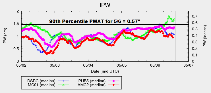
The upper-level low currently centered over California will continue its slow shift eastward today, bringing deep southwesterly flow aloft across Colorado. This southwesterly flow will continue to stream mid- and high-level moisture across the area (along with an embedded mid-level disturbance), bringing an increase in clouds and precipitation during this period, especially to the High Country. Storms will mainly be high-based across the mountains, which will provide more gusty winds than rain, and plenty of virga will be noted. Near the CO/WY border, the threat of heavy rain will exist where the best overlap of moisture, lift, and instability will occur. As indicated in the Precipitable Water chart below, moisture over western Colorado is above the 90th percentile (as measured at Grand Junction) for this date. With that consideration in mind, the inclusion of a low-end, low flood threat is warranted.
Further east over the lower elevations, “inverted-V soundings” are noted this afternoon and evening, which will limit precipitation but enhance the risk for strong winds/microburst activity. The best chances for this activity will be along/near favorable terrain, such as the Urban Corridor, western portions of the Southeast Plains, Raton Ridge, Palmer Ridge, and the Cheyenne Ridge. Rain rates will remain on the low side; details are given in the zone-specific forecast discussions below.
As we move into the evening and overnight hours, storms will diminish from south to north across the lower elevations as drier air moves in from the south/southwest. For the higher terrain, isolated showers and perhaps a few weak thunderstorms will continue overnight and into tomorrow morning.
Today’s Flood Threat Map
For more information on today’s flood threat, see the map below (hover over threat areas for more details). For Zone-Specific forecasts, jump below the map.

Zone-Specific Forecasts
Urban Corridor, Southeast Plains, Palmer Ridge, Raton Ridge, and Northeast Plains:
Today will be unseasonably warm across the area, with high temperatures in the 70s and 80s. Isolated showers/thunderstorms are possible, mainly near the favored terrain mentioned above. Inverted-V soundings show an atmosphere favorable for more wind than rain, and microbursts will be a threat this afternoon and early evening. Overall, the main result from any thunderstorm activity will be gusty winds and light rain/virga. The best chance for measurable precipitation will be along the CO/WY border.
Timing: Noon – 9 PM, with storms diminishing from south to north beginning during the early evening hours.
Northwest Slope, Northern Mountains, and Front Range:
This will be the area with the best overlap of moisture, lift, and instability. Scattered showers and thunderstorms are expected today, and a few will be strong/severe. The strongest storms will be capable of damaging winds (greater than 60 mph), hail (1” in diameter), and brief periods of moderate-to-heavy rainfall. Maximum rain rates will be 0.8-1.1 inches/hour. Low-lying areas near streams with higher streamflows due to snowmelt will be the main concerns, as well as street ponding in urban areas.
A couple of isolated showers/weak thunderstorms will continue through the evening and into the overnight hours, though the heavy rain threat will be reduced due to the loss of daytime heat/instability.
Timing: Currently – Midnight, with a few lingering into tomorrow morning
Central Mountains, Grand Valley, San Juan Mountains, and Southwest Slope:
Isolated-to-scattered showers/thunderstorms expected today. Gusty winds and light rain will be the main result due to drier air near the surface. A stronger thunderstorm or two over the Grand Valley is possible, with the main threat being damaging wind gusts (greater than 50 mph) and small hail. Maximum rain rates across these regions will be 0.3-0.6 inches/hour.
Timing: 11 AM – 11 PM, with a few lingering into tomorrow morning
Southeast Mountains and San Luis Valley:
A couple Isolated gusty showers/weak thunderstorms are expected over the higher peaks of the Southeast Mountains today. The main impacts will be gusty winds and virga/light rain. For the San Luis Valley, it will be dry and warm with gusty winds. The NWS noted that fuels aren’t critically dry, so fire concerns are tempered a bit. With that said, I would be careful with any flames and take extra caution today.
Timing: Noon – 8 PM