Issue Date: 5/7/2016
Issue Time: 9:30 AM
A LOW FLOOD THREAT IS FORECAST FOR PORTIONS OF THE NORTHERN MOUNTAINS, FRONT RANGE, URBAN CORRIDOR, AND NORTHEAST PLAINS.
The upper-level low will continue its slow progression to the east-northeast, leading to another day of unsettled weather across much of the state. The Southeast Plains and Raton Ridge will be largely left out of the action, with only isolated storm chances along/near the mountains and along the CO/KS border. For the rest of the state, scattered showers and thunderstorms are expected this afternoon/evening, with a few continuing overnight across the Northeast Plains.
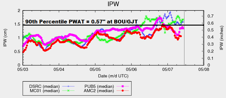
Over much of the High Country, the showers/thunderstorms can be categorized as fairly garden variety. The exceptions to this rule will be across the Northern Mountains, Front Range, Northwest Slope and Central Mountains regions. In those regions, especially the Northern Mountains and Front Range, strong-to-severe storms will be possible. Moderate-to-heavy rainfall will be possible with the strongest storms, thanks to precipitable water values in the 90th percentile for the date; hence the inclusion in the low flood threat area.
The main area of focus for today’s flood threat includes the Front Range (for reasons stated above), Urban Corridor, and Northeast Plains. A leeside surface low/trough has developed in response to the upper-level forcing, which will provide reinforcement of moisture into the area with east/northeast surface flow. In addition, the direction of the surface winds will be important in the development of strong-to-severe thunderstorms, capable of producing damaging winds, small hail, moderate-to-heavy rainfall, and a couple of tornadoes. It is May in Colorado and the atmosphere has received the memo.
Showers and thunderstorms will begin around lunchtime, increasing in coverage through the afternoon and early evening hours before diminishing during the late evening hours. Some activity is expected to continue into the overnight and early morning hours tomorrow across the Northeast Plains as moisture wraps around the backside of the surface low. For more details, including expected rain rates, please see the zone-specific forecast discussions below.
Today’s Flood Threat Map
For more information on today’s flood threat, see the map below (hover over threat areas for more details). For Zone-Specific forecasts, jump below the map.

Zone-Specific Forecasts
Urban Corridor, Palmer Ridge, and Northeast Plains:
Scattered showers and thunderstorms are expected, a few will be strong-to-severe. Primary threats are damaging winds, lightning, small hail, and a couple of tornadoes. Moderate-to-heavy rainfall will attend the stronger storms, but storm motions will help mitigate the flood threat somewhat. Maximum rain rates will be 1.2-1.8 inches/hour.
Timing: 11 AM – 9 PM, with scattered showers/weak thunderstorms continuing overnight and into the early morning hours across the far Northeast Plains.
Raton Ridge and Southeast Plains:
The main weather story for these regions today will be the warm temperatures and breezy conditions. Only a couple isolated showers/thunderstorms are possible near the Southeast Mountains and along the CO/KS border. Moisture will be less than points to the north and east, with maximum rain rates breaking down like this:
Near the Southeast Mountains: 0.3-0.6 inches/hour
Along the CO/KS border: 0.4-0.8 inches/hour
Timing: 1 PM – 8 PM
Grand Valley, San Juan Mountains, and Southwest Slope:
Scattered showers and thunderstorms expected throughout the day and into the evening hours. Moisture values will be relatively low, but there will be enough instability for thunderstorms to produce gusty winds and perhaps some small hail. Maximum rain rates will be 0.3-0.5 inches/hour.
Timing: 11 AM – 9 PM, with a few light showers/weak thunderstorms lingering into the overnight hours
Front Range, Northern Mountains, Central Mountains, and Northwest Slope:
Scattered showers and thunderstorms are expected, and a couple will become strong-to-severe. The Front Range will hold the highest relative threat of severe thunderstorms, especially along the foothills. Moderate-to-heavy rain will attend the strongest thunderstorms, and maximum rain rates will break down like this:
Front Range: 1.0-1.5 inches/hour
Northern Mountains: 0.8-1.2 inches/hour
Central Mountains: 0.4-0.8 inches/hour
Northwest Slope: 0.3-0.6 inches/hour
Storm motions will help mitigate the flood threat somewhat over the Front Range and Northern Mountains, but a low flood threat is still warranted.
Timing: 11 AM – 9 PM, with a lingering shower or two possible over the Front Range until midnight
San Luis Valley and Southeast Mountains:
The main story today will be the warm and breezy conditions, but a couple isolated showers/thunderstorms cannot be ruled out (mainly over and near the higher terrain). Any thunderstorms that develop will be responsible for more wind/lightning than rain. Maximum rain rates will be 0.15-0.3 inches/hour.
Timing: 11 AM – 7 PM