Issue Date: 5/5/2016
Issue Time: 9:25 AM
NO FLOOD THREAT IS FORECAST.
The upper-level ridge aloft will continues its slow progression eastward today as the upper-level low continues to make its way onshore California. This movement will result in the ridge axis sitting overtop eastern Colorado by this afternoon, and allow southwesterly flow aloft to transport moisture across western Colorado. The placement of the ridge axis and presence of moisture will lead to a “Tale of Two Forecasts,” so to speak.
East of the mountains, the name of the game today will be dry conditions and above average high temperatures. Most locations will run about 5 to 8 degrees above normal, with some locations running as high as 10 to 15 degrees above normal. By tonight, mid- and high-level clouds will increase across the area as moisture continues to flow in from the southwest and the ridge axis continues to shift eastward.
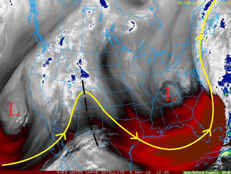
Along and west of the Continental Divide, the increase in moisture will allow for an uptick in showers/weak thunderstorms. Activity will remain isolated-to-widely scattered in nature across much of the High Country, but will focus mainly on the higher peaks of the San Juan Mountains, Southwest Slope, Grand Valley, and Northwest Slope regions. Moisture will continue to stream in through the night, so isolated showers/weak thunderstorms will continue through overnight and into tomorrow morning. For more information on rain rates, please see the zone specific forecast discussions below.
One final note: Expect mountain streamflows to increase as higher terrain snow begins to melt relatively quickly thanks to above average temperatures.
Today’s Flood Threat Map
For more information on today’s flood threat, see the map below (hover over threat areas for more details). For Zone-Specific forecasts, jump below the map.

Zone-Specific Forecasts
Urban Corridor, Southeast Plains, Palmer Ridge, Raton Ridge, and Northeast Plains:
Dry and above average warmth expected under sun-drenched skies. Highs today will be in the 70s and 80s across the plains, with upper 60s/low 70s expected for the higher elevations of the Palmer Ridge and Raton Ridge. Mid- and high-level clouds will increase tonight as the ridge continues to push east and moisture begins to overspread the area.
Northwest Slope, Grand Valley, San Juan Mountains, San Luis Valley, and Southwest Slope:
Isolated-to-widely scattered showers/weak thunderstorms are expected, mainly across the higher terrain. Weak steering winds will try and push activity over the valleys, but showers/thunderstorms die off quickly if they are successful. Activity is expected to continue in isolated fashion overnight. Rain rates will be low throughout the period, with maximum rates of 0.15-0.25 inches/hour.
Timing: 11 AM – 9 PM, with a couple isolated showers/weak thunderstorms possible overnight.
Northern Mountains, Front Range, Central Mountains, and Southeast Mountains:
Isolated-to-widely scattered showers/weak thunderstorms are expected, as well, with the best relative chances over the Front Range and Central Mountains. Activity will come to an end shortly after sunset due to the loss of daytime heat. Rain rates will be low, with maximum rates of 0.1-0.2 inches/hour.
Timing: Noon – 9 PM