FTB 06-09-2016: Drying/Warming Trend Begins, a Few Storms Remain

Issue Date: 6/9/2016
Issue Time: 9:48 AM

A LOW FLOOD THREAT CONTINUES FOR A PORTION OF THE LOS PINOS RIVER IN LA PLATA COUNTY.

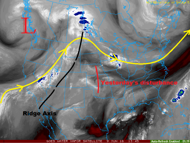
Current water vapor imagery shows that yesterday’s disturbance has shifted east over the Great Plains and upper-level ridging is building in from the west. This change in the upper-levels overhead will bring about a much warmer and dryer day than the last few. Temperatures are expected to above average statewide, with a few locations as much as 10-15 degrees above normal.

Even so, there will be enough lingering moisture and daytime heating to support a few isolated-to-widely scattered showers/thunderstorms. The best coverage of this activity will occur over/near the higher terrain where daytime heating will break through the cap. Rain rates will generally be low, and no flash flood threats are warranted. The primary threats from any shower/thunderstorm activity over/near the higher terrain will be small hail, gusty winds, and lightning.

WV_20160609

The one area to watch will be the far southeast plains/eastern Raton Ridge, where there will be just enough upper-level support overtop sufficient instability/moisture to produce isolated strong-to-severe thunderstorms near the state border. Otherwise, the area will be mostly sunny and hot, much like the rest of the plains. For more details, please see the zone-specific discussions below.

Today’s Flood Threat Map

For more information on today’s flood threat, see the map below (hover over threat areas for more details). For Zone-Specific forecasts, jump below the map.

Flood Threat Legend

Zone-Specific Forecasts

Urban Corridor, Northeast Plains, Palmer Ridge, and Raton Ridge:

Mostly sunny and hot will be the name of the game today, minus a few isolated showers/thunderstorms for locations near the higher terrain. The Raton Ridge will see the most activity, relatively speaking. Eastern portions of the Raton Ridge could see an isolated stronger thunderstorm for reasons outlined above. Maximum rain rates are as follows:

Urban Corridor, Northeast Plains, and western Raton Ridge: 0.2-0.5 inches/hour
Palmer Ridge: 0.4-0.6 inches/hour
Eastern Raton Ridge: 0.6-1.2 inches/hour

Timing: Noon – 11 PM

Southeast Plains:

Mostly sunny and hot for most, with a few isolated showers/thunderstorms. For portions of the Southeast Plains near the higher terrain, rain rates will be fairly low with the primary threats being gusty winds, lightning, and small hail. Eastern portions of the region, including Baca, Prowers, Bent, Las Animas, and Kiowa counties, will see an isolated strong-to-severe thunderstorm or two this afternoon/evening. The main threats from these storms will be large hail and gusty winds, with brief periods of heavy rainfall. Maximum rainfall rates are as follows:

Western Portions of the Southeast Plains: 0.2-0.5 inches/hour
Eastern Portions of the Southeast Plains: 1.2-1.8 inches/hour

Timing: 1 PM – Midnight

Front Range, Northern Mountains, Central Mountains, Northwest Slope, Grand Valley, Southwest Slope, San Juan Mountains, Southeast Mountains, and San Luis Valley:

Isolated-to-scattered showers/thunderstorms are expected to break up the otherwise mostly sunny and hot day. Most of the activity will remain anchored to the higher terrain, but a few storms will drift over valleys. The Central Mountains, San Juan Mountains, and Southeast Mountains will see the most storms as compared to the other regions.

The best coverage will occur during peak heating, with storms diminishing quickly after sunset. Overall, the primary threats will be gusty winds, lightning, and small hail. Maximum rain rates will be 0.25-0.6 inches/hour.

Timing: 11 AM – 10 PM

FTB 06-08-2016: Another Unsettled Day as Weak Wave Passes Overhead

Issue Date: 6/8/2016
Issue Time: 10:15 AM

A MODERATE FLOOD THREAT HAS BEEN ISSUED FOR PORTIONS OF THE SAN MIGUEL RIVER IN MONTROSE AND SAN MIGUEL COUNTIES.

A LOW FLOOD THREAT CONTINUES FOR PORTIONS OF THE LOS PINOS RIVER IN LA PLATA COUNTY AND GORE CREEK/BLACK GORE CREEK IN EAGLE COUNTY.

One more unsettled day ahead before the upper-level ridge takes over and brings a drying trend to Colorado. For today, though, the weak disturbance aloft will combine with sufficient moisture and instability to kick off another period of showers and thunderstorms. Moisture will be less than previous days across much of the state, so no flood threat is warranted. You can see the decrease in moisture well on the IPW chart below. Pueblo (pink line), Boulder (blue line), and Schriever AFB (red line) have all taken fairly significant dips since yesterday evening. Grand Junction (green line), on the other hand, has seen an increase in moisture. This, plus orographic support, portends the reality of today; the most numerous showers/thunderstorms will occur over the higher terrain, with lesser coverage over the lower elevations of eastern Colorado.

IPW_20160608

Aside from the showers and thunderstorms, the rising rivers in the High Country deserve some attention. Above average temperatures have accelerated snowmelt, bringing some low-lying flooding conditions to portions of Montrose, San Miguel, La Plata, and Eagle Counties. The San Miguel River (moderate flood threat) should fall back below flood stage by later this afternoon. These areas have been highlighted in the flood threat map below.

Today’s Flood Threat Map

For more information on today’s flood threat, see the map below (hover over threat areas for more details). For Zone-Specific forecasts, jump below the map.

Flood Threat Legend

Zone-Specific Forecasts

Urban Corridor, Northeast Plains, Palmer Ridge, Southeast Plains, and Raton Ridge:

Scattered showers and thunderstorms are expected. The atmosphere has dried a bit and instability values are down, as well, so storms will be less intense than previous days. Westerly winds will also promote low-level drying over the Urban Corridor and western portions of the Northeast Plains, which means the primary threat will shift to gusty winds/microburst potential.

Elsewhere, the stronger storms will produce hail and brief periods of moderate-to-heavy rainfall. Maximum rain rates are as follows:

Urban Corridor and Raton Ridge: 0.6-1.2 inches/hour
Northeast Plains, Southeast Plains, and Palmer Ridge: 1.2-1.8 inches/hour

Timing: Noon – 10 PM

Front Range, Northern Mountains, Central Mountains, Northwest Slope, Grand Valley, Southwest Slope, San Juan Mountains, Southeast Mountains, and San Luis Valley:

Scattered showers/thunderstorms expected, mainly over the higher terrain. The best coverage of storms will occur over the Northern Mountains, Front Range, Central Mountains, and San Juan Mountains as they will be underneath the best upper-level support while benefitting from orographic influences. Elsewhere, more isolated coverage is expected. The primary threats from stronger storms will be small hail, lightning, and gusty winds, along with brief moderate rainfall. Maximum rain rates are as follows:

Front Range, Northern Mountains, Central Mountains, and San Juan Mountains: 0.6-0.9 inches/hour
Southeast Mountains: 0.2-0.6 inches/hour
Southwest Slope, Grand Valley, and Northwest Slope: 0.4-0.8 inches/hour

Timing: 11 AM – 11 PM

FTB 06-07-2016: Isolated-to-Scattered Thunderstorms Expected

Issue Date: 6/7/2016
Issue Time: 10:14 AM

A LOW FLOOD THREAT IS FORECAST FOR PORTIONS OF THE NORTHERN MOUNTAINS, FRONT RANGE, URBAN CORRIDOR, SOUTHEAST MOUNTAINS, RATON RIDGE, PALMER RIDGE, NORTHEAST PLAINS, AND SOUTHEAST PLAINS.

A LOW FLOOD THREAT HAS BEEN ISSUED FOR PORTIONS OF THE LOS PINOS RIVER IN LA PLATA COUNTY AND GORE CREEK/BLACK GORE CREEK IN EAGLE COUNTY.

The overall atmospheric setup is similar to yesterday, minus a few subtle differences. The weak wave that undercut the upper-level ridge has slid slowly to the east, leaving much of Colorado under weakly diffluent flow aloft. This will help promote upward motion, supporting isolated-to-scattered showers and thunderstorms again during this period. Adequate moisture and instability will push a few storms into the strong-to-severe category, mainly along the Front Range/Southeast Mountains and eastward across the plains and Palmer/Raton Ridge regions. The primary threats from these storms will be hail, gusty winds, and periods of heavy rain.

IPW_20160607

For points to the west, shower/thunderstorm coverage will be more isolated, favoring the higher terrain. Gusty outflow winds and lightning will the primary concerns from this activity, with only brief light-to-moderate rainfall expected. For southwest Colorado, including much of the San Juan, Southwest Slope, and San Luis Valley regions, drier air working in from the west-southwest will suppress thunderstorm activity.

For more details regarding timing, rain rates, and impacts, please see the zone-specific discussions below.

Today’s Flood Threat Map

For more information on today’s flood threat, see the map below (hover over threat areas for more details). For Zone-Specific forecasts, jump below the map.

Flood Threat Legend

Zone-Specific Forecasts

Urban Corridor, Northeast Plains, Palmer Ridge, Southeast Plains, and Raton Ridge:

Scattered showers and thunderstorms are expected this afternoon/evening. A few will become strong-to-severe. Today’s storms should move to the east at a decent clip which will mitigate the flood threat somewhat. Even so, storms will be capable of heavy rain, with maximum rain rates in the 1.8-2.5 inches/hour range. For this reason, the low flood threat has been issued. Other hazards include hail, gusty winds, and lightning.

Timing: 1 PM – 11 PM, ending from west to east

Front Range and Southeast Mountains:

Scattered showers and thunderstorms expected this afternoon and evening. A couple will be strong, producing periods of heavy rain, small hail, and gusty winds. The maximum rain rates will be 1.6-2.3 inches/hour for the Front Range, and 0.8-1.4 inches/hour for the Southeast Mountains.

Timing: Noon – 9 PM

Northern Mountains, Central Mountains, Northwest Slope, and Grand Valley:

Isolated showers/thunderstorms are expected this afternoon and evening, mainly over the higher terrain. A few will move over adjacent valleys. The primary threats from these storms will be gusty winds and lightning, with periods of light-to-moderate rainfall. The best chance at brief heavy rain will occur over eastern portions of the Northern Mountains. Maximum rain rates are as follows:

Northern Mountains: 0.8-1.4 inches/hour
Central Mountains: 0.6-0.8 inches/hour
Northwest Slope and Grand Valley: 0.3-0.6 inches/hour

Timing: Noon – 9 PM

Southwest Slope, San Juan Mountains, and San Luis Valley:

Mostly sunny and warm, with high temperatures above average for the date. A few clouds will develop over the higher terrain of the San Juan Mountains region this afternoon, but nothing more than brief light-to-moderate rain (0.4-0.8 inches/hour) is expected.

Timing: Noon – 6 PM

FTB 06-06-2016: Strong-to-Severe Storms Pose a Low-to-Moderate Flood Threat

Issue Date: 6/6/2016
Issue Time: 10:24 AM

A MODERATE FLOOD THREAT IS FORECAST FOR PORTIONS OF THE FRONT RANGE, URBAN CORRIDOR AND PALMER RIDGE REGIONS.

A LOW FLOOD THREAT IS FORECAST FOR PORTIONS OF THE URBAN CORRIDOR, NORTHEAST PLAINS, PALMER RIDGE, FRONT RANGE, NORTHERN MOUNTAINS, CENTRAL MOUNTAINS, SOUTHEAST MOUNTAINS, RATON RIDGE, AND SOUTHEAST PLAINS.

A weak upper ridge will be in place over western Colorado through this period, placing weak, northwest flow aloft over the mountains and eastern Colorado. Within this setup, the upper-levels will be weakly diffluent, promoting upward motion through this afternoon/evening. At the low- and mid-levels, easterly upslope flow will reinforce/enhance moisture from the surface to approximately 700 millibars. Precipitable water in the 12Z Denver sounding (0.70 inches) was near the 90th percentile for the date. As you can see below, Pueblo IPW (pink line) was nearing 1 inch, and the general upward trend will continue for Boulder (blue line), and Schriever AFB (red line).

As the day wears on and the temperature rises, instability will rise, as well. Due to weak upper-level flow, wind shear will not be great this afternoon, but will be sufficient for clusters of strong-to-severe storms along/south of I-70 and along/east of the Continental Divide. These storms will be capable of small hail, gusty winds, and brief moderate-to-heavy rainfall. With this setup in place, there is some concern of slow-moving/training thunderstorms, mainly over the Front Range, Urban Corridor and Palmer Ridge. With this in mind, a moderate flood threat is warranted where local enhancement of rainfall plus impervious surfaces provide additional concerns. For areas north of I-70 and along/east of the Continental Divide, scattered showers and thunderstorms are expected, but will not have the same gusto as those to the south. The main threats from these storms will be brief moderate-to-heavy rainfall, small hail, and gusty winds.

IPW_20160606

Moving west of the Continental Divide, isolated-to-scattered thunderstorms are expected over the higher terrain as daytime heating works on enough moisture still clinging to the area. A few will drift over the valleys. The primary threats from these storms will be gusty winds and small hail, with brief light-to-moderate rainfall. Otherwise, expect temperatures to remain 10-15 degrees above seasonal average.

For more details on timing and rain rates, please see the zone-specific forecast discussions below.

Today’s Flood Threat Map

For more information on today’s flood threat, see the map below (hover over threat areas for more details). For Zone-Specific forecasts, jump below the map.

Flood Threat Legend

Zone-Specific Forecasts

Urban Corridor, Northeast Plains, Palmer Ridge, Southeast Plains, and Raton Ridge:

Scattered showers and thunderstorms expected today and tonight, tapering off around midnight. A few strong-to-severe thunderstorm clusters are possible, mainly along/south of I-70. Maximum rain rates vary:

Urban Corridor and Palmer Ridge: 1.8-2.4 inches/hour
Northeast Plains: 1.4-1.8 inches/hour
Southeast Plains: 1.8-2.5 inches/hour
Raton Ridge: 1.6-2.2 inches/hour

Timing: Noon – Midnight

Northern Mountains, Central Mountains, Front Range, and Southeast Mountains:

Isolated-to-scattered showers/thunderstorms, most numerous over the Front Range and Southeast Mountains. Most storms will produce gusty winds and brief moderate rainfall, but a few stronger storms (mainly south of I-70) will mix in hail and brief heavy rain. Maximum rain rates will be:

Front Range: 1.6-2.2 inches/hour
Central Mountains: 1.2-1.6 inches/hour
Northern Mountains: 1.2-1.8 inches/hour
Southeast Mountains: 1.6-2.2 inches/hour

Timing: 11 AM – Midnight

Northwest Slope, Grand Valley, Southwest Slope, San Juan Mountains, and San Luis Valley:

Isolated-to-scattered thunderstorms are expected this afternoon/evening, mainly over the higher terrain. The valleys will see a few drift overhead. The main impacts from storms in these regions will be gusty winds, small hail, and brief light-to-moderate rainfall. Most rain rates will be 0.2-0.4 inches/hour, but stronger storms will push closer to 0.6-0.8 inches/hour.

Timing: 11 AM – 11 PM