Issue Date: 6/6/2016
Issue Time: 10:24 AM
A MODERATE FLOOD THREAT IS FORECAST FOR PORTIONS OF THE FRONT RANGE, URBAN CORRIDOR AND PALMER RIDGE REGIONS.
A LOW FLOOD THREAT IS FORECAST FOR PORTIONS OF THE URBAN CORRIDOR, NORTHEAST PLAINS, PALMER RIDGE, FRONT RANGE, NORTHERN MOUNTAINS, CENTRAL MOUNTAINS, SOUTHEAST MOUNTAINS, RATON RIDGE, AND SOUTHEAST PLAINS.
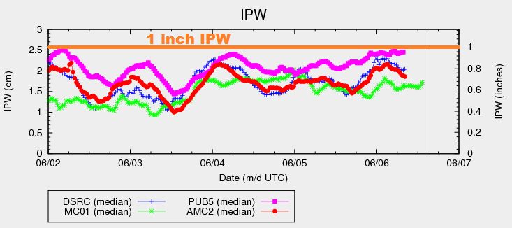
A weak upper ridge will be in place over western Colorado through this period, placing weak, northwest flow aloft over the mountains and eastern Colorado. Within this setup, the upper-levels will be weakly diffluent, promoting upward motion through this afternoon/evening. At the low- and mid-levels, easterly upslope flow will reinforce/enhance moisture from the surface to approximately 700 millibars. Precipitable water in the 12Z Denver sounding (0.70 inches) was near the 90th percentile for the date. As you can see below, Pueblo IPW (pink line) was nearing 1 inch, and the general upward trend will continue for Boulder (blue line), and Schriever AFB (red line).
As the day wears on and the temperature rises, instability will rise, as well. Due to weak upper-level flow, wind shear will not be great this afternoon, but will be sufficient for clusters of strong-to-severe storms along/south of I-70 and along/east of the Continental Divide. These storms will be capable of small hail, gusty winds, and brief moderate-to-heavy rainfall. With this setup in place, there is some concern of slow-moving/training thunderstorms, mainly over the Front Range, Urban Corridor and Palmer Ridge. With this in mind, a moderate flood threat is warranted where local enhancement of rainfall plus impervious surfaces provide additional concerns. For areas north of I-70 and along/east of the Continental Divide, scattered showers and thunderstorms are expected, but will not have the same gusto as those to the south. The main threats from these storms will be brief moderate-to-heavy rainfall, small hail, and gusty winds.
Moving west of the Continental Divide, isolated-to-scattered thunderstorms are expected over the higher terrain as daytime heating works on enough moisture still clinging to the area. A few will drift over the valleys. The primary threats from these storms will be gusty winds and small hail, with brief light-to-moderate rainfall. Otherwise, expect temperatures to remain 10-15 degrees above seasonal average.
For more details on timing and rain rates, please see the zone-specific forecast discussions below.
Today’s Flood Threat Map
For more information on today’s flood threat, see the map below (hover over threat areas for more details). For Zone-Specific forecasts, jump below the map.

Zone-Specific Forecasts
Urban Corridor, Northeast Plains, Palmer Ridge, Southeast Plains, and Raton Ridge:
Scattered showers and thunderstorms expected today and tonight, tapering off around midnight. A few strong-to-severe thunderstorm clusters are possible, mainly along/south of I-70. Maximum rain rates vary:
Urban Corridor and Palmer Ridge: 1.8-2.4 inches/hour
Northeast Plains: 1.4-1.8 inches/hour
Southeast Plains: 1.8-2.5 inches/hour
Raton Ridge: 1.6-2.2 inches/hour
Timing: Noon – Midnight
Northern Mountains, Central Mountains, Front Range, and Southeast Mountains:
Isolated-to-scattered showers/thunderstorms, most numerous over the Front Range and Southeast Mountains. Most storms will produce gusty winds and brief moderate rainfall, but a few stronger storms (mainly south of I-70) will mix in hail and brief heavy rain. Maximum rain rates will be:
Front Range: 1.6-2.2 inches/hour
Central Mountains: 1.2-1.6 inches/hour
Northern Mountains: 1.2-1.8 inches/hour
Southeast Mountains: 1.6-2.2 inches/hour
Timing: 11 AM – Midnight
Northwest Slope, Grand Valley, Southwest Slope, San Juan Mountains, and San Luis Valley:
Isolated-to-scattered thunderstorms are expected this afternoon/evening, mainly over the higher terrain. The valleys will see a few drift overhead. The main impacts from storms in these regions will be gusty winds, small hail, and brief light-to-moderate rainfall. Most rain rates will be 0.2-0.4 inches/hour, but stronger storms will push closer to 0.6-0.8 inches/hour.
Timing: 11 AM – 11 PM