FTB 06-13-2016: Active Day Ahead, Severe Storms Likely

Issue Date: 6/13/2016
Issue Time: 9:10 AM

A MODERATE FLOOD THREAT HAS BEEN ISSUED FOR PORTIONS OF THE NORTHEAST PLAINS, SOUTHEAST PLAINS, PALMER RIDGE, AND URBAN CORRIDOR.

A LOW FLOOD THREAT SURROUNDS THE MODERATE FLOOD THREAT, INCLUDING PORTIONS OF THE RATON RIDGE, FRONT RANGE, SOUTHEAST MOUNTAINS, CENTRAL MOUNTAINS, AND NORTHERN MOUNTAINS.

A LOW FLOOD THREAT HAS BEEN ISSUED FOR THE GREEN RIVER IN WEST CENTRAL MOFFAT COUNTY, THE CACHE LA POUDRE RIVER AT THE CANYON MOUTH AFFECTING LARIMER COUNTY, AND THE CACHE LA POUDRE RIVER NEAR GREELEY AFFECTING WELD COUNTY.

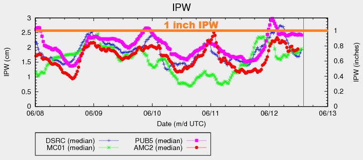
This period looks to be an active one across the state as a mid-/upper-level disturbance shifts across the region. At the surface, dewpoints continue to sit in the 40s/50s across eastern Colorado, with a few locations reporting dewpoints near 60 F. This moisture shows up well in the IPW chart below: Pueblo (pink line) is above 1 inch, and both Boulder (blue) and Schriever AFB (red) are near 0.8 inches. The Grand Junction station shows that it is a bit drier to the west, but sufficient moisture remains.

IPW_20160613

For areas along/east of the Continental Divide, ingredients are coming together for another day of scattered strong/severe storms, with an uptick in intensity over yesterday’s storms expected. All hazards are possible with severe storms, including damaging winds, large hail, isolated tornadoes, and heavy rain. Storm motions will mitigate the flood threat somewhat, as storms will move at a decent clip to the east. Even so, owing to the depth of moisture and available instability/upper-level support, a moderate flood threat is warranted.

West of the Continental Divide, moisture/instability will be less than points to the east, and storm motions will be quicker, general speaking. A few stronger storms will be possible this afternoon/early evening, producing small hail, gusty outflow winds, and brief periods of moderate-to-heavy rain. Even so, storm motions preclude the issuance of any flood threat for these areas.

Today’s Flood Threat Map

For more information on today’s flood threat, see the map below (hover over threat areas for more details). For Zone-Specific forecasts, jump below the map.

Flood Threat Legend

Zone-Specific Forecasts

Urban Corridor, Northeast Plains, Palmer Ridge, Raton Ridge, and Southeast Plains:

An active weather day ahead, with scattered thunderstorms expected. The environment is favorable for the development of strong/severe storms, with all severe hazards possible: This includes hail (up to 1.5-2.5 inches in diameter), damaging winds (greater than 50 mph), and isolated tornadoes, along with heavy rain. Maximum rain rates are as follows:

Urban Corridor, Palmer Ridge, and Southeast Plains: 1.8-2.5 inches/hour
Raton Ridge: 1.5-2.0 inches/hour
Northeast Plains: 2.0-3.0 inches/hour

Timing: Noon – Midnight, with a few showers/thunderstorms continuing into the morning hours, mainly along the eastern CO border

Front Range, Northern Mountains, Central Mountains, and Southeast Mountains:

Scattered showers/thunderstorms are expected, and a couple will be on the strong side. The main threats from storms will be gusty winds, hail, and periods of moderate-to-heavy rainfall. Maximum rain rates are follows:

Front Range: 1.5-2.0 inches/hour
Northern Mountains, Central Mountains, and Southeast Mountains: 0.8-1.2 inches/hour

Timing: 10 AM – 10 PM, with a couple isolated showers/thunderstorms lingering until 2 AM.

Northwest Slope, Grand Valley, Southwest Slope, San Juan Mountains, and San Luis Valley:

Scattered showers/thunderstorms are expected. The higher terrain will see the most coverage, but due to storm motions and the nature of the broad-scale lift overspreading the area, valleys will get in on the scattered showers/storms, as well. A few storms will become strong, producing small hail and gusty outflow winds. Brief periods of moderate-to-heavy rainfall are possible, but storm motions preclude the issuance of any flood threat. Even so, be on the lookout for minor street ponding underneath stronger thunderstorms, mainly where drainage is poor.

Maximum rain rates…

Northwest Slope: 0.3-0.6 inches/hour
Grand Valley, Southwest Slope, and San Juan Mountains: 0.4-0.8 inches/hour
San Luis Valley: 0.2-0.4 inches/hour

Timing: Ongoing – 9 PM, with a couple of isolated showers/weak thunderstorms continuing until 11 PM over the higher terrain.

FTB 06-12-2016: Ingredients Coming Together for Moderate Flood Threat

Issue Date: 6/12/2016
Issue Time: 10:00 AM

A MODERATE FLOOD THREAT HAS BEEN ISSUED FOR PORTIONS OF THE NORTHEAST PLAINS, SOUTHEAST PLAINS, PALMER RIDGE, RATON RIDGE, URBAN CORRIDOR, AND FRONT RANGE.

A LOW FLOOD THREAT SURROUNDS THE MODERATE FLOOD THREAT, AND ALSO INCLUDES PORTIONS OF THE NORTHERN MOUNTAINS, CENTRAL MOUNTAINS, AND SOUTHEAST MOUNTAINS.

A LOW FLOOD THREAT HAS BEEN ISSUED FOR THE GREEN RIVER IN WEST CENTRAL MOFFAT COUNTY, THE CACHE LA POUDRE RIVER AT THE CANYON MOUTH AFFECTING LARIMER COUNTY, AND THE CACHE LA POUDRE RIVER NEAR GREELEY AFFECTING WELD COUNTY.

Current analysis shows an upper-level trough digging across the western US, slowly sliding into the Great Basin today. At the surface, a weak cool front has sagged southward into eastern Colorado, and will continue to do so through the remainder of today/tonight. Behind the front, winds will take on a more easterly component this afternoon, enhancing the low-level moisture that is already above average. In fact, according to the 12Z Denver sounding, precipitable water this morning is in the 90th percentile. A quick look at the IPW chart below reveals the good moisture available, especially for Pueblo (pink line) which is near 1 inch.

IPW_20160612
For areas along/east of the Continental Divide, scattered thunderstorms are expected today/tonight. Sufficient moisture and warm layer depths of ~3 km will result in efficient rain processes, bringing the threat of heavy rain to the forefront today. Wind shear isn’t substantial, but combined with sufficient instability and moisture, a few organized strong-to-severe storms are expected. Outflow boundaries working westward off of eastern plains convection may regenerate storms along the Front Range/Urban Corridor/Palmer Ridge overnight, working eastward with time. Overall, things will quiet down as we move into tomorrow morning.

Turning our attention west of the Continental Divide, moisture will decrease this afternoon across much of the area as drier air is transported in from the southwest. This drier air will bring a relative minimum to thunderstorm coverage (and potential rain rates) across the western third of the state. Thus, these locations are not included in the low flood threat area. The next surge of moisture will work back into the area early tomorrow morning, and a few showers may redevelop over the higher terrain near the CO/UT border.

Today’s Flood Threat Map

For more information on today’s flood threat, see the map below (hover over threat areas for more details). For Zone-Specific forecasts, jump below the map.

Flood Threat Legend

Zone-Specific Forecasts

Urban Corridor, Palmer Ridge, Raton Ridge, Southeast Plains, and Northeast Plains:

Scattered thunderstorms are expected today/tonight, and a few will become strong-to-severe. Heavy rain will be the main threat, with maximum rain rates as follows:

Urban Corridor: 1.6-2.2 inches/hour
Palmer Ridge and Raton Ridge: 1.8-2.6 inches/hour
Southeast Plains and Northeast Plains: 2.5-3.0 inches/hour

A few scattered showers/thunderstorms may regenerate overnight near the higher terrain, moving eastward with time. Chance of occurrence is 30%, so it warrants a mention.

Timing: Noon – Midnight, but a few storms will continue into the early morning hours tomorrow

Front Range, Northern Mountains, Central Mountains, and Southeast Mountains:

Scattered thunderstorms are expected today/tonight. Instability will be less across these regions as compared to lower elevations to the east, but sufficient moisture/lift/wind shear will allow for a few stronger storms to produce moderate-to-heavy rain. Maximum rain rates are follows:

Front Range: 1.5-2.0 inches/hour
Northern Mountains, Central Mountains, and Southeast Mountains: 0.9-1.3 inches/hour

A few isolated-to-scattered storms may regenerate tonight along the Front Range, moving eastward with time. Chance of occurrence is 30%, so it warrants a mention.

Timing: 11 AM – 10 PM, with a couple showers/storms lingering into the early morning

Northwest Slope, San Juan Mountains, San Luis Valley, Grand Valley and Southwest Slope:

Isolated-to-scattered showers/thunderstorms expected today, mainly over/near the higher terrain. Gusty winds and lightning will be the main threats, with brief periods of moderate rainfall. The best coverage, relatively speaking, with be across the San Juan Mountains. Activity will come to an end from south to north this evening, diminishing fairly quickly after sunset. A couple showers may redevelop tomorrow morning near the CO/UT along the edge of the next moisture surge. Maximum rain rates will be:

Northwest Slope, Grand Valley, and Southwest Slope: 0.4-0.8 inches/hour
San Juan Mountains: 0.5-0.9 inches/hour
San Luis Valley: 0.2-0.5 inches/hour

Timing: 11 AM – 10 PM

FTB 06-11-2016: Upper Ridge Shifting East

Issue Date: 6/11/2016
Issue Time: 9:35 AM

A LOW FLOOD THREAT IS ISSUED FOR PORTIONS OF THE SOUTHWEST SLOPE, SAN JUAN MOUNTAINS, CENTRAL MOUNTAINS, FRONT RANGE, NORTHERN MOUNTAINS, URBAN CORRIDOR, SOUTHEAST PLAINS, SOUTHEAST MOUNTAINS, PALMER RIDGE, AND RATON RIDGE.

A LOW FLOOD THREAT HAS BEEN ISSUED FOR THE GREEN RIVER IN WEST CENTRAL MOFFAT COUNTY, THE CACHE LA POUDRE RIVER AT THE CANYON MOUTH AFFECTING LARIMER COUNTY, AND THE CACHE LA POUDRE RIVER NEAR GREELEY AFFECTING WELD COUNTY.

The upper-level ridge will remain over Colorado today, although the axis will have shifted east a bit. This shift east has allowed for an increase in moisture across far western Colorado, and kept moisture relatively steady across eastern Colorado (see IPW chart below). Additionally, the shift in the ridge axis means that warming aloft will take place over the eastern plains, while slight cooling aloft will occur over the High Country. This will promote isolated-to-scattered showers/thunderstorms across the High Country and adjacent lower elevations, while areas further east are essentially capped off. The caveat to this will be the Palmer Ridge and Raton Ridge, where weak surface convergence will be enough to produce a couple isolated thunderstorms. Overall, activity east of the mountains should come to an end by 9-10 PM, while over the mountains storms continue until around 11 PM, with a few lingering past midnight.

IPW_20160611

Today’s Flood Threat Map

For more information on today’s flood threat, see the map below (hover over threat areas for more details). For Zone-Specific forecasts, jump below the map.

Flood Threat Legend

Zone-Specific Forecasts

Urban Corridor, Palmer Ridge, Raton Ridge, Southeast Plains, Northeast Plains:

Hot temperatures will continue today underneath mostly sunny skies. A few isolated thunderstorms are possible, mainly along/near the higher terrain. As stated above, the Palmer Ridge and Raton Ridge will see a couple isolated thunderstorms develop as the result of weak surface convergence. Enough residual moisture will combine with the threat of convergent outflow boundaries from High Country convection to warrant the low flood threat. Most rain rates will be in the 0.2-0.5 inch/hour range, but stronger storms could produce rain rates of 1.2-1.6 inches/hour.

Timing: 2 PM – 10 PM

Northern Mountains, Northwest Slope, Front Range, Central Mountains, San Juan Mountains, Southeast Mountains, San Luis Valley, Grand Valley and Southwest Slope:

Mostly sunny and warm, with temperatures again running above average. Scattered showers/thunderstorms are expected to develop again this afternoon and last into the nighttime hours, mainly over the higher terrain. A few will drift over lower valleys. Most rain rates will remain in the 0.3-0.6 inches/hour range, but a couple stronger storms will have the potential to produce rain rates of 0.8-1.2 inches/hour. Otherwise, the main threats will be gusty winds and lightning.

Timing: 11 AM – 3 AM

FTB 06-10-2016: High Pressure Overhead

Issue Date: 6/10/2016
Issue Time: 10:05 AM

A LOW FLOOD THREAT HAS BEEN ISSUED FOR THE GREEN RIVER IN WEST CENTRAL MOFFAT COUNTY, THE CACHE LA POUDRE RIVER AT THE CANYON MOUTH AFFECTING LARIMER COUNTY, AND THE CACHE LA POUDRE RIVER NEAR GREELEY AFFECTING WELD COUNTY.

Upper-level ridging will be overtop Colorado today/tonight, leading to a day filled with mostly sunny skies and warm temperatures. There is a bit of moisture still in place beneath the ridge, evidenced in the IPW chart below. Closer inspection of the vertical profile of the moisture reveals that much of it resides in the mid-levels and, aside from some residual moisture near the surface, the lower-levels are fairly dry. This means that any isolated thunderstorms that are able to fire up will remain high-based, producing more wind and lightning than rain.

IPW_20160610

Many of the isolated thunderstorms will remain anchored to the higher terrain of the Continental Divide, Front Range, and San Juan Mountains. A few will drift over the adjacent valleys and lower elevations including the Urban Corridor and western portions of the Southeast Plains, Northeast Plains, and Raton Ridge. One or two isolated thunderstorms will also be possible across the Palmer Ridge as slight surface convergence develops this afternoon. Otherwise, the bulk of the state will remain mostly sunny and hot. For more details, please see the zone-specific forecast discussions below.

Today’s Flood Threat Map

For more information on today’s flood threat, see the map below (hover over threat areas for more details). For Zone-Specific forecasts, jump below the map.

Flood Threat Legend

Zone-Specific Forecasts

Urban Corridor, Northeast Plains, Palmer Ridge, Raton Ridge, and Southeast Plains:

Mostly sunny and hot will be the main weather story today, only broken up by a few isolated thunderstorms. Storms will be high-based, posing more of a gusty wind and lightning threat than rain. Wind gusts will be up to 40-50 mph. Maximum rain rates will remain fairly low, clocking in at 0.3-0.6 inches/hour. High temperatures will be in the low-to-mid 90s for most, with a few locations across the far eastern plains and in the Arkansas River Valley flirting with 100 F.

Timing: 2 PM – 10 PM

Front Range, Northern Mountains, Central Mountains, San Juan Mountains, Southeast Mountains, and San Luis Valley:

Mostly sunny and warm, with isolated thunderstorms over the higher terrain. A few storms will drift over adjacent valleys, and all will be fairly slow moving. Dry air beneath the cloud layer will reduce the threat of heavy rain, instead focusing today’s main threats on gusty winds (up to 40-50 mph) and lightning. Maximum rain rates will be 0.2-0.5 inches/hour.

Timing: Noon – 10 PM

Northwest Slope, Grand Valley, Southwest Slope:

Mostly sunny and hot. High temperatures will be running well above normal again today. A few high-based, fair weather clouds will be noted over the higher terrain of eastern portions of these regions.