Issue Date: 6/12/2016
Issue Time: 10:00 AM
A MODERATE FLOOD THREAT HAS BEEN ISSUED FOR PORTIONS OF THE NORTHEAST PLAINS, SOUTHEAST PLAINS, PALMER RIDGE, RATON RIDGE, URBAN CORRIDOR, AND FRONT RANGE.
A LOW FLOOD THREAT SURROUNDS THE MODERATE FLOOD THREAT, AND ALSO INCLUDES PORTIONS OF THE NORTHERN MOUNTAINS, CENTRAL MOUNTAINS, AND SOUTHEAST MOUNTAINS.
A LOW FLOOD THREAT HAS BEEN ISSUED FOR THE GREEN RIVER IN WEST CENTRAL MOFFAT COUNTY, THE CACHE LA POUDRE RIVER AT THE CANYON MOUTH AFFECTING LARIMER COUNTY, AND THE CACHE LA POUDRE RIVER NEAR GREELEY AFFECTING WELD COUNTY.
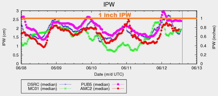
Current analysis shows an upper-level trough digging across the western US, slowly sliding into the Great Basin today. At the surface, a weak cool front has sagged southward into eastern Colorado, and will continue to do so through the remainder of today/tonight. Behind the front, winds will take on a more easterly component this afternoon, enhancing the low-level moisture that is already above average. In fact, according to the 12Z Denver sounding, precipitable water this morning is in the 90th percentile. A quick look at the IPW chart below reveals the good moisture available, especially for Pueblo (pink line) which is near 1 inch.
For areas along/east of the Continental Divide, scattered thunderstorms are expected today/tonight. Sufficient moisture and warm layer depths of ~3 km will result in efficient rain processes, bringing the threat of heavy rain to the forefront today. Wind shear isn’t substantial, but combined with sufficient instability and moisture, a few organized strong-to-severe storms are expected. Outflow boundaries working westward off of eastern plains convection may regenerate storms along the Front Range/Urban Corridor/Palmer Ridge overnight, working eastward with time. Overall, things will quiet down as we move into tomorrow morning.
Turning our attention west of the Continental Divide, moisture will decrease this afternoon across much of the area as drier air is transported in from the southwest. This drier air will bring a relative minimum to thunderstorm coverage (and potential rain rates) across the western third of the state. Thus, these locations are not included in the low flood threat area. The next surge of moisture will work back into the area early tomorrow morning, and a few showers may redevelop over the higher terrain near the CO/UT border.
Today’s Flood Threat Map
For more information on today’s flood threat, see the map below (hover over threat areas for more details). For Zone-Specific forecasts, jump below the map.

Zone-Specific Forecasts
Urban Corridor, Palmer Ridge, Raton Ridge, Southeast Plains, and Northeast Plains:
Scattered thunderstorms are expected today/tonight, and a few will become strong-to-severe. Heavy rain will be the main threat, with maximum rain rates as follows:
Urban Corridor: 1.6-2.2 inches/hour
Palmer Ridge and Raton Ridge: 1.8-2.6 inches/hour
Southeast Plains and Northeast Plains: 2.5-3.0 inches/hour
A few scattered showers/thunderstorms may regenerate overnight near the higher terrain, moving eastward with time. Chance of occurrence is 30%, so it warrants a mention.
Timing: Noon – Midnight, but a few storms will continue into the early morning hours tomorrow
Front Range, Northern Mountains, Central Mountains, and Southeast Mountains:
Scattered thunderstorms are expected today/tonight. Instability will be less across these regions as compared to lower elevations to the east, but sufficient moisture/lift/wind shear will allow for a few stronger storms to produce moderate-to-heavy rain. Maximum rain rates are follows:
Front Range: 1.5-2.0 inches/hour
Northern Mountains, Central Mountains, and Southeast Mountains: 0.9-1.3 inches/hour
A few isolated-to-scattered storms may regenerate tonight along the Front Range, moving eastward with time. Chance of occurrence is 30%, so it warrants a mention.
Timing: 11 AM – 10 PM, with a couple showers/storms lingering into the early morning
Northwest Slope, San Juan Mountains, San Luis Valley, Grand Valley and Southwest Slope:
Isolated-to-scattered showers/thunderstorms expected today, mainly over/near the higher terrain. Gusty winds and lightning will be the main threats, with brief periods of moderate rainfall. The best coverage, relatively speaking, with be across the San Juan Mountains. Activity will come to an end from south to north this evening, diminishing fairly quickly after sunset. A couple showers may redevelop tomorrow morning near the CO/UT along the edge of the next moisture surge. Maximum rain rates will be:
Northwest Slope, Grand Valley, and Southwest Slope: 0.4-0.8 inches/hour
San Juan Mountains: 0.5-0.9 inches/hour
San Luis Valley: 0.2-0.5 inches/hour
Timing: 11 AM – 10 PM