FTB 06-25-2016: Another Day of Rumbling Thunderstorms

Issue Date: 6/25/2016
Issue Time: 9:22 AM

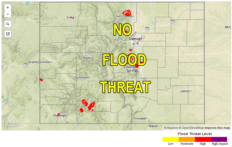
A LOW FLOOD THREAT IS FORE FOR PORTIONS OF THE SOUTHEAST PLAINS, RATON RIDGE, PALMER RIDGE, FRONT RANGE, SOUTHEAST MOUNTAINS, AND URBAN CORRIDOR.

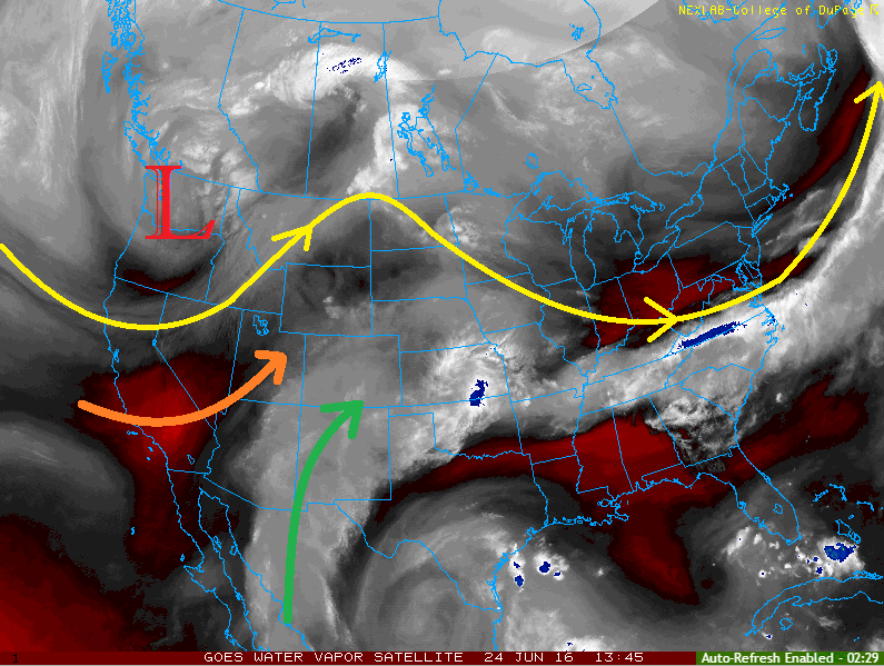
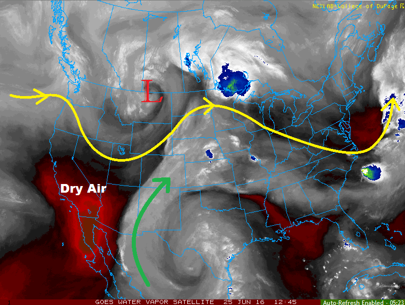
Current water vapor analysis shows the upper-level low/trough sliding across the northern Rockies/northern high plains, ridging over central US, and ridging building along the West Coast. Within this pattern, dry air is being transported into western/northwestern Colorado from the west/southwest, and mid-level moisture (green arrow) continues to be funneled into southern/eastern Colorado. Meanwhile, a cool front is shifting southward across the state today, later stalling over the I-70 corridor in the mountains and near Highway 50 across the lower elevations of eastern Colorado.

The plume of moisture and location of the cool front will do a good job delineating the areas expecting the majority of shower/thunderstorm activity during this period. Over the mountains, areas along and south of I-70 will see the bulk of activity, with coverage generally increasing from north to south and west to east. North of I-70 will remain mainly dry today, minus a shower or two over the Northern Mountains and northern extents of the Front Range.

WV_20160625

To the east, the Northeast Plains and portions of the Urban Corridor north of I-70 will see very little activity, with only an isolated thunderstorm or two possible near the higher terrain and along the Cheyenne Ridge. Brief periods of light-to-moderate rainfall are possible, but the main threats from any of this activity will be gusty winds and lightning. To the south of I-70, coverage will increase (just as moisture increases) from north to south. Scattered thunderstorms will be capable of producing locally heavy rainfall, strong winds, small hail, and lightning. A couple of storms will become marginally severe, producing hail up to 1.5 inches in diameter and strong winds up to 60 mph.

Today’s Flood Threat Map

For more information on today’s flood threat, see the map below (hover over threat areas for more details). For Zone-Specific forecasts, jump below the map.

Flood Threat Legend

Zone-Specific Forecasts

Urban Corridor (north of I-70) and Northeast Plains:

Mostly sunny and a bit cooler today, with an isolated shower/thunderstorm or two along/near the Front Range and Cheyenne Ridge. Drier air has been filtered in and will keep rain rates sufficiently beneath flooding concerns. Maximum rain rates will be 0.2-0.4 inches/hour.

Timing: 2 PM – 9 PM

Urban Corridor (south of I-70), Palmer Ridge, Raton Ridge, and Southeast Plains:

Partly sunny with isolated-to-scattered showers/thunderstorms this afternoon/evening. A few will be strong/severe, with the main threats being locally heavy rainfall, hail (up to 1-1.5 inches in diameter), strong winds (up to 60 mph), and lightning. Maximum rain rates will vary:

Urban Corridor: 0.8-1.4 inches/hour
Palmer Ridge: 1.2-1.6 inches/hour
Raton Ridge and Southeast Plains: 2.0-3.0 inches/hour

Timing: Noon – 10 PM, with a couple thunderstorms rumbling across the far Southeast Plains/Raton Ridge until 1 AM.

Front Range, Central Mountains, San Juan Mountains, San Luis Valley, and Southeast Mountains:

Partly sunny with isolated-to-scattered showers/thunderstorms expected this afternoon/evening. Rain rates will remain below flash flood thresholds for most areas, but a low threat exists in the southern Front Range and Southeast Mountains where moisture will be best. Maximum rain rates are as follows:

Front Range and Southeast Mountains: 0.8-1.2 inches/hour
Central Mountains, San Juan Mountains, and San Luis Valley: 0.4-0.6 inches/hour

Timing: 11 AM – 9 PM

Northern Mountains, Northwest Slope, Grand Valley, and Southwest Slope:

Mostly sunny with temperatures remaining near, or slightly above, normal. Areas to the north of the front will be a few degrees cooler than yesterday. An isolated shower/weak thunderstorm or two cannot be ruled out over the higher terrain, resulting in mainly gusty winds and lightning. Maximum rain rates will be below 0.4 inches/hour.

Timing: 11 AM – 7 PM

FTB 06-24-2016: Battle Between Dry and Moist Air

Issue Date: 6/24/2016
Issue Time: 10:05 AM

A LOW FLOOD THREAT IS ISSUED FOR PORTIONS OF THE NORTHEAST PLAINS, PALMER RIDGE, SOUTHEAST PLAINS, URBAN CORRIDOR, AND RATON RIDGE.

Current analysis of the water vapor imagery this morning will tell us a lot about the weather expected today. Below, you can see the upper-level low spinning over the Pacific Northwest, with trough-ing extending southward across the West Coast/Great Basin. To the south and east, a broad upper-level ridge remains. Both of these larger scale features are funneling different types of air masses across Colorado (moist air = green arrow, dry air = orange arrow).

The drier air being transported in from the west will lead to a hot and dry day for the lower elevations of western Colorado. In fact, a Red Flag Warning has been issued for portions of the Northwest Slope, Grand Valley, and Southwest Slope. Enough moisture will remain for isolated-to- scattered showers/thunderstorms over the higher terrain of the San Juan Mountains, Central Mountains, and Northern Mountains.

WV_20160624

Along and east of the Continental Divide, deeper moisture and sufficient instability will lead to another period of scattered showers/thunderstorms. Wind shear values are less favorable than yesterday, but a few storms will become strong-to-severe. The main threats will be small hail, strong winds, and lightning, with periods of moderate-to-heavy rainfall.

Today’s Flood Threat Map

For more information on today’s flood threat, see the map below (hover over threat areas for more details). For Zone-Specific forecasts, jump below the map.

Flood Threat Legend

Zone-Specific Forecasts

Urban Corridor, Northeast Plains, Palmer Ridge, Raton Ridge, and Southeast Plains:

Another round of scattered showers/thunderstorms are expected today/tonight. A few will become strong-to-severe, with the main threats being small hail, strong winds, and lightning. Storm motions will be quick enough to help mitigate the flood threat somewhat. Maximum rain rates vary:

Urban Corridor: 1.0-1.4 inches/hour
Palmer Ridge: 1.0-1.6 inches/hour
Northeast Plains, Southeast Plains, and Raton Ridge: 2.0-2.5 inches/hour

Timing: Noon – 1 AM, storms will end from west to east as they exit the state.

Front Range and Southeast Mountains:

Scattered showers/thunderstorms expected over the Front Range this afternoon/evening, with more isolated coverage expected over the Southeast Mountains. Gusty winds, lightning, small hail, and brief periods of moderate rainfall are the main threats. Maximum rain rates will be 0.5-0.8 inches/hour.

Timing: 11 AM – 9 PM

Northwest Slope, Grand Valley, and Southwest Slope:

Hot and dry conditions are expected today. Fire weather concerns are highlighted by the issuance of Red Flag Warnings for portions of the Northwest Slope, Grand Valley, and Southwest Slope. Higher terrain along eastern fringes of these zones may see an isolated shower/thunderstorm this afternoon/evening, resulting in mainly gusty winds, lightning, and light rainfall. Maximum rain rates from any activity will be 0.15-0.3 inches/hour.

Timing: 11 AM – 7 PM.

A cool front moving southward through the area tonight/overnight may result in a couple isolated showers/thunderstorms developing over the Northwest Slope after 9 PM.

Northern Mountains, Central Mountains, San Juan Mountains, and San Luis Valley:

Isolated-to- scattered showers/thunderstorms are expected over the higher terrain this afternoon/evening, with storm motions allowing for activity to move over valleys with time. The main threats from storms today will be gusty winds and lightning, with brief periods of light-to-moderate rainfall. Maximum rain rates vary:

Northern Mountains and Central mountains: 0.5-0.8 inches/hour
San Luis Valley: 0.4-0.7 inches/hour
San Juan Mountains: 0.6-1.0 inches/hour
Timing: 11 AM – 8 PM.

A cool front moving southward through the area tonight/overnight may result in a couple isolated showers/thunderstorms developing over the Northern Mountains after 9 PM.

FTB 06-23-2016: Widespread Showers and Storms With Heavy Rainfall Possible

Issue Date: Thursday, June 23rd, 2016
Issue Time: 10:29AM MDT

MODERATE flood threat for parts of Palmer Ridge, Northeast Plains and Southeast Plains
LOW flood threat for parts of Urban Corridor and Front Range

After a long two to three weeks at the helm, the ridge that started off the North American west coast and slowly propagated eastward has weakened (see water vapor image below). This has allowed more southerly flow to enter the picture for Colorado. This morning, a distinct ripple in the flow is seen near the Utah/Colorado border. This disturbance is providing upward motion and resulting in scattered showers on the Western Slope. As this disturbance moves east, expect instability from solar heating to allow for scattered to widespread shower and storm activity for most of the state. However, the flood threat will be limited to eastern areas where low-level moisture content is higher (and extends through a deeper part of the atmosphere). A severe weather threat also exists east of the Divide as strong shear will support large hail and gusty winds in the strongest thunderstorms.

wv_markup

Today’s Flood Threat Map

For more information on today’s flood threat, see the map below (hover over threat areas for more details). For Zone-Specific forecasts, scroll below the map.

Flood Threat Legend

Zone-Specific Forecasts:

Northeast Plains, Palmer Ridge, Southeast Plains:

Sunny early then turning partly cloudy with scattered to widespread showers and storms developing by early afternoon. Max 1-hr rainfall up to 2.1 inches is possible, and max 3-hour rainfall up to 3.2 inches is possible where repeated storms pass through. Scattered roadway and field flooding is likely. A Moderate flood threat has been issued for parts of the area, with a Low flood threat elsewhere. In addition to the heavy rainfall threat, the strongest storm cells will be capable of producing hail up to 1.25 inches in diameter and gusty winds up to 60mph. A low-end tornado threat also exists towards the Kansas border.

Primetime: 2pm through midnight, with the latest threat lasting in the far eastern areas

Urban Corridor, Southeast Mountains, Raton Ridge, Front Range:

Sunny early, then partly cloudy with scattered showers and thunderstorms. Maximum 1-hour rain rates up to 1.9 inches will lead to isolated roadway and field flooding. Mud flows and debris slides are possible over higher terrain. Gusty winds up to 60mph could accompany the strongest cells. A Low flood threat has been issued for part of the region.

Primetime: 1pm through 9pm

San Juan Mountains, San Luis Valley, Northern Mountains, Grand Valley, Northwest Slope, Southwest Slope, Central Mountains:

Mostly cloudy with scattered showers early, turning to thunderstorms by noon. Max 1-hour rain rates up to 0.75 inches possible. Gusty winds up to 55 mph could accompany the strongest storm cells. Flooding is not expected.

Primetime: 11am through 8pm

FTB 06-22-2016: Much Cooler With Some Rainfall, Along With Gusty Winds

Issue Date: Wednesday, June 22nd, 2016
Issue Time: 10:45AM MDT

— Flooding is NOT expected today

The famous ridge that has been in our discussion for the better part of two weeks has shifted slightly east this morning, and is now centered over west Texas (see water vapor image below). The northward flow to its west has allowed some mid-level moisture to enter Colorado from the morning. Farther east, a cool-front has resulted in substantial cooling and some drying of the lower atmosphere east of the Continental Divide. However, this front will have a hard time making it all the way into southeast Colorado and hot temperatures are expected here again (it’s already 93F in Springfield as of 10AM!).

wv_markup

There are two features that will drive most of today’s weather. The heating of the higher terrain will result in scattered to widespread high-elevation thunderstorms, very similar to past days. In addition, the aforementioned cool front could (keyword: could) also provide a focusing mechanism for storm activity in southeast Colorado. Although some model guidance is painting a rather wet picture today, the downsloping flow and relatively minimal low-level moisture profile makes this rather hard to believe. Instead, we see a similar evolution of rainfall, but more coverage, compared to yesterday. Flooding is not expected today. Instead, gusty winds may be the bigger story.

Today’s Flood Threat Map

For more information on today’s flood threat, see the map below (hover over threat areas for more details). For Zone-Specific forecasts, scroll below the map.
FTB_20160621

Zone-Specific Forecasts:

Urban Corridor, Northeast Plains, Palmer Ridge, Southeast Plains, Southeast Mountains, Raton Ridge, Front Range:

Partly cloudy and much cooler with high temperatures around seasonal normal, except for the far southeast where hot weather will persist. Scattered to widespread high-elevation thunderstorms are expected this afternoon into the early overnight hours (in the southeast). Max 10-minute rainfall up to 0.4 inches will be possible, with max 1-hour rainfall up to 0.8 inches. Flooding is not expected today. Primetime is as follows:

Raton Ridge and Southeast Plains: 1pm to midnight

All other regions: 1pm to 8pm

There is a possibility of persistent gusty winds along the Palmer Ridge, Front Range and Raton Ridge as thunderstorm mix higher momentum air to the surface. Sustained winds of 30-40 mph, with gusts up to 60 mph, can be expected immediately behind the passage of thunderstorms.

San Juan Mountains, San Luis Valley, Northern Mountains, Grand Valley, Northwest Slope, Southwest Slope, Central Mountains:

Sunny early and slightly cooler today. Scattered weak thunderstorms will be possible in the higher terrain especially in the central and southern parts of the area. Max one hour rainfall up to 0.5 inches is possible. Flooding is not expected today. Gusty winds up to 50mph could accompany some of the stronger storms.