Issue Date: 6/24/2016
Issue Time: 10:05 AM
A LOW FLOOD THREAT IS ISSUED FOR PORTIONS OF THE NORTHEAST PLAINS, PALMER RIDGE, SOUTHEAST PLAINS, URBAN CORRIDOR, AND RATON RIDGE.
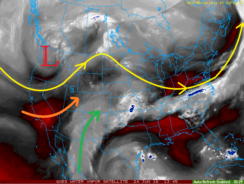
Current analysis of the water vapor imagery this morning will tell us a lot about the weather expected today. Below, you can see the upper-level low spinning over the Pacific Northwest, with trough-ing extending southward across the West Coast/Great Basin. To the south and east, a broad upper-level ridge remains. Both of these larger scale features are funneling different types of air masses across Colorado (moist air = green arrow, dry air = orange arrow).
The drier air being transported in from the west will lead to a hot and dry day for the lower elevations of western Colorado. In fact, a Red Flag Warning has been issued for portions of the Northwest Slope, Grand Valley, and Southwest Slope. Enough moisture will remain for isolated-to- scattered showers/thunderstorms over the higher terrain of the San Juan Mountains, Central Mountains, and Northern Mountains.
Along and east of the Continental Divide, deeper moisture and sufficient instability will lead to another period of scattered showers/thunderstorms. Wind shear values are less favorable than yesterday, but a few storms will become strong-to-severe. The main threats will be small hail, strong winds, and lightning, with periods of moderate-to-heavy rainfall.
Today’s Flood Threat Map
For more information on today’s flood threat, see the map below (hover over threat areas for more details). For Zone-Specific forecasts, jump below the map.

Zone-Specific Forecasts
Urban Corridor, Northeast Plains, Palmer Ridge, Raton Ridge, and Southeast Plains:
Another round of scattered showers/thunderstorms are expected today/tonight. A few will become strong-to-severe, with the main threats being small hail, strong winds, and lightning. Storm motions will be quick enough to help mitigate the flood threat somewhat. Maximum rain rates vary:
Urban Corridor: 1.0-1.4 inches/hour
Palmer Ridge: 1.0-1.6 inches/hour
Northeast Plains, Southeast Plains, and Raton Ridge: 2.0-2.5 inches/hour
Timing: Noon – 1 AM, storms will end from west to east as they exit the state.
Front Range and Southeast Mountains:
Scattered showers/thunderstorms expected over the Front Range this afternoon/evening, with more isolated coverage expected over the Southeast Mountains. Gusty winds, lightning, small hail, and brief periods of moderate rainfall are the main threats. Maximum rain rates will be 0.5-0.8 inches/hour.
Timing: 11 AM – 9 PM
Northwest Slope, Grand Valley, and Southwest Slope:
Hot and dry conditions are expected today. Fire weather concerns are highlighted by the issuance of Red Flag Warnings for portions of the Northwest Slope, Grand Valley, and Southwest Slope. Higher terrain along eastern fringes of these zones may see an isolated shower/thunderstorm this afternoon/evening, resulting in mainly gusty winds, lightning, and light rainfall. Maximum rain rates from any activity will be 0.15-0.3 inches/hour.
Timing: 11 AM – 7 PM.
A cool front moving southward through the area tonight/overnight may result in a couple isolated showers/thunderstorms developing over the Northwest Slope after 9 PM.
Northern Mountains, Central Mountains, San Juan Mountains, and San Luis Valley:
Isolated-to- scattered showers/thunderstorms are expected over the higher terrain this afternoon/evening, with storm motions allowing for activity to move over valleys with time. The main threats from storms today will be gusty winds and lightning, with brief periods of light-to-moderate rainfall. Maximum rain rates vary:
Northern Mountains and Central mountains: 0.5-0.8 inches/hour
San Luis Valley: 0.4-0.7 inches/hour
San Juan Mountains: 0.6-1.0 inches/hour
Timing: 11 AM – 8 PM.
A cool front moving southward through the area tonight/overnight may result in a couple isolated showers/thunderstorms developing over the Northern Mountains after 9 PM.