Issue Date: Thursday, June 23rd, 2016
Issue Time: 10:29AM MDT
— MODERATE flood threat for parts of Palmer Ridge, Northeast Plains and Southeast Plains
— LOW flood threat for parts of Urban Corridor and Front Range
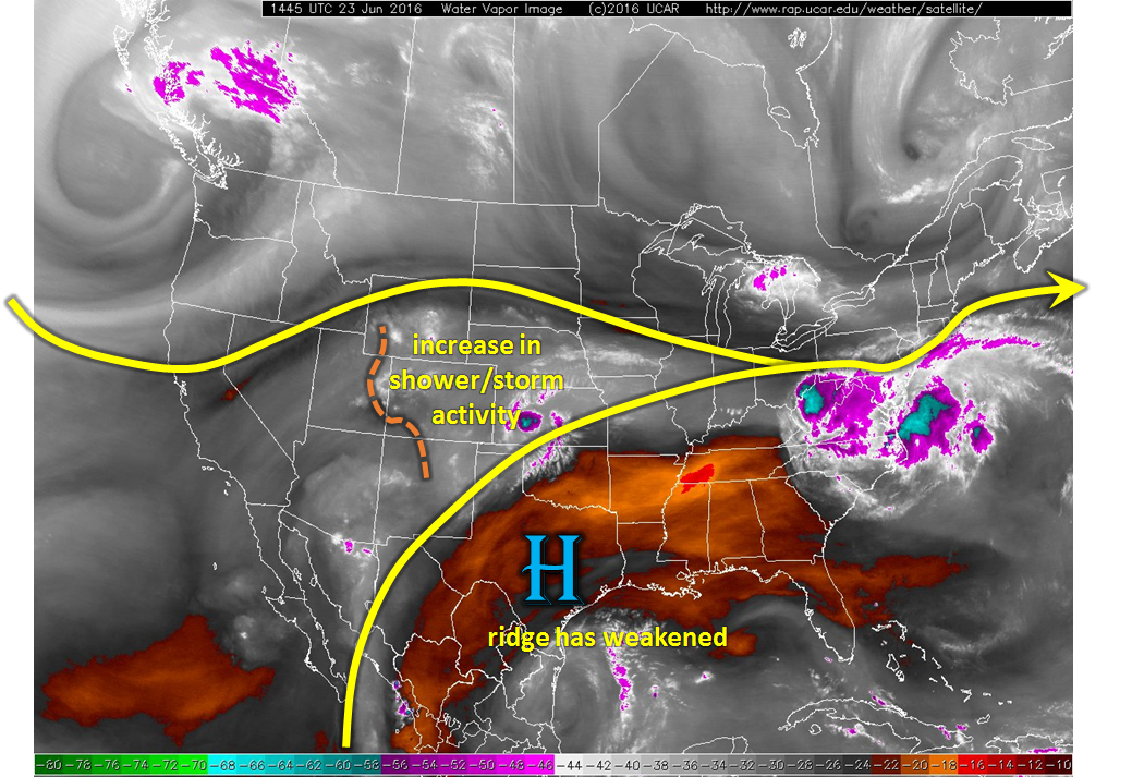
After a long two to three weeks at the helm, the ridge that started off the North American west coast and slowly propagated eastward has weakened (see water vapor image below). This has allowed more southerly flow to enter the picture for Colorado. This morning, a distinct ripple in the flow is seen near the Utah/Colorado border. This disturbance is providing upward motion and resulting in scattered showers on the Western Slope. As this disturbance moves east, expect instability from solar heating to allow for scattered to widespread shower and storm activity for most of the state. However, the flood threat will be limited to eastern areas where low-level moisture content is higher (and extends through a deeper part of the atmosphere). A severe weather threat also exists east of the Divide as strong shear will support large hail and gusty winds in the strongest thunderstorms.
Today’s Flood Threat Map
For more information on today’s flood threat, see the map below (hover over threat areas for more details). For Zone-Specific forecasts, scroll below the map.

Zone-Specific Forecasts:
Northeast Plains, Palmer Ridge, Southeast Plains:
Sunny early then turning partly cloudy with scattered to widespread showers and storms developing by early afternoon. Max 1-hr rainfall up to 2.1 inches is possible, and max 3-hour rainfall up to 3.2 inches is possible where repeated storms pass through. Scattered roadway and field flooding is likely. A Moderate flood threat has been issued for parts of the area, with a Low flood threat elsewhere. In addition to the heavy rainfall threat, the strongest storm cells will be capable of producing hail up to 1.25 inches in diameter and gusty winds up to 60mph. A low-end tornado threat also exists towards the Kansas border.
Primetime: 2pm through midnight, with the latest threat lasting in the far eastern areas
Urban Corridor, Southeast Mountains, Raton Ridge, Front Range:
Sunny early, then partly cloudy with scattered showers and thunderstorms. Maximum 1-hour rain rates up to 1.9 inches will lead to isolated roadway and field flooding. Mud flows and debris slides are possible over higher terrain. Gusty winds up to 60mph could accompany the strongest cells. A Low flood threat has been issued for part of the region.
Primetime: 1pm through 9pm
San Juan Mountains, San Luis Valley, Northern Mountains, Grand Valley, Northwest Slope, Southwest Slope, Central Mountains:
Mostly cloudy with scattered showers early, turning to thunderstorms by noon. Max 1-hour rain rates up to 0.75 inches possible. Gusty winds up to 55 mph could accompany the strongest storm cells. Flooding is not expected.
Primetime: 11am through 8pm