FTB 07-11-2016: Passage of Cool Front will Lower Afternoon Highs

Issue Date: 7/11/2016
Issue Time: 9:58 AM

NO FLOOD THREAT IS FORECAST.

Cooler air behind a passing cool front will bring a more pleasant day to Colorado, with temperatures 5-10 degrees below yesterday’s highs for many locations. This doesn’t mean the fire danger is over, as Red Flag Warnings are still in play across portions of the Northern Mountains, Front Range, Southeast Mountains, Raton Ridge, Southeast Plains, San Luis Valley, and Central Mountains regions. Gusty winds will still be an issue in those areas, as well as dry fuels and low relative humidity. Firefighting efforts in those areas will not be helped by Mother Nature; at least not in the short-term.

Isolated-to-widely scattered thunderstorms are back in the forecast for the Northeast Plains, northern portions of the Southeast Plains, and the Palmer Ridge. How far west into Colorado these storms form will depend on how well the surface moisture can hang on versus westerly winds trying to mix it out.

IPW_20160711

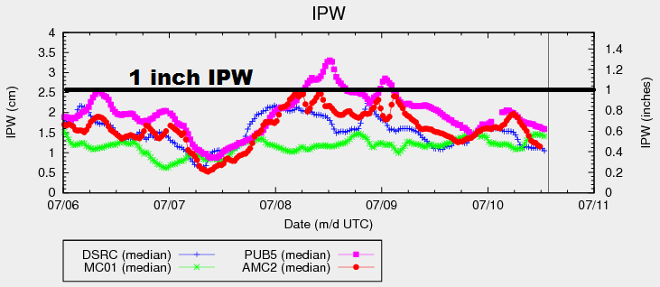
These storms will mainly be garden variety, with a strong/marginally severe thunderstorm mixing in. Deep moisture is still lacking, shown well in the IPW graph above. This will keep storms from producing rain rates capable of flash flooding; thus, no flood threat issuance. For more information on rain rates and timing, please see the zone specific discussion below.

Today’s Flood Threat Map

For more information on today’s flood threat, see the map below (hover over threat areas for more details). For Zone-Specific forecasts, jump below the map.

Flood Threat Legend

Zone-Specific Forecasts

Urban Corridor, Northeast Plains, Southeast Plains, Palmer Ridge and Raton Ridge:

Mostly sunny with high temperatures a few degrees cooler than yesterday will be the weather story for most. A few isolated-to-widely scattered thunderstorms will develop over the Northeast Plains this afternoon/evening, generally moving to the east with time. There’s a 30% chance that an isolated storm or two moves across the Palmer Ridge and northern portions of the Southeast Plains, but it is highly dependent on moisture resiliency as described above. Maximum rain rates from these storms will be 0.5-1.0 inches/hour.

Even less than the chances outlined above, but it needs mentioning, is the 10% chance that an isolated thunderstorm impacts the Urban Corridor. If this occurs, it will result in mainly gusty winds/lightning, and a brief period of light rainfall. Maximum rain rates from this activity will be 0.1-0.3 inches/hour.

Timing: 1 PM – Midnight for Northeast Plains/Urban Corridor, 3 PM – 2 AM for Palmer Ridge, and 4 PM – 1 AM for Southeast Plains

Northwest Slope, Northern Mountains, Central Mountains, Grand Valley, Front Range, San Juan Mountains, Southwest Slope, Southeast Mountains, and San Luis Valley:

Cooler than yesterday, but gusty winds, dry fuels, and low relative humidity will keep the fire danger elevated for much of the area. Red Flag Warnings are in place (described above in the main discussion), so please be careful if you are outside today. A few fires continue to burn:

Beaver Creek Fire (Jackson County)
Cold Springs Fire (Boulder County)
Spring Gulch Fire (Douglas County)
Hayden Pass Fire (Fremont County)

Otherwise, the main weather story will be the mostly sunny skies.

FTB 07-10-2016: High Fire Danger

Issue Date: 7/10/2016
Issue Time: 9:07 AM

NO FLOOD THREAT IS FORECAST.

An upper-level low currently spinning over the Pacific Northwest will slide eastward today, becoming centered over western Montana by midnight tonight. In response, the pressure gradient across Colorado will tighten, bringing gusty winds to much of the state. Additionally, drier air from the west/southwest will push into Colorado, lowering the IPW values currently shown on the graph below. Abundant sunshine will push high temperatures well above average across a majority of the state, with some records being flirted with along the I-25 corridor and eastern plains.

IPW_20160710

With hot, dry, and gusty conditions expected, fire danger is high across much of the state. Red Flag Warnings are in effect for portions of the following regions: Front Range, Urban Corridor, Palmer Ridge, Southeast Plains, Southeast Mountains, San Luis Valley, Southwest Slope, Grand Valley, Central Mountains, Northern Mountains, and Northwest Slope. Explosive fire growth is a concern, so please be careful with any outdoor activities. The Cold Creek Fire continues to burn in Boulder County (0% contained), as well as the Beaver Creek Fire in Jackson County (5% contained).

The lone exception to the dry conditions will be the far Northeast Plains and Southeast Plains, much like yesterday. The dryline will sit near the eastern CO border, and areas to the east will retain enough moisture for the development of isolated thunderstorms. Rain rates will remain below flash flood thresholds. The main threats will be strong winds, large hail, and lightning, with brief periods of moderate rainfall. For more details, please see the zone-specific forecast discussions below.

Today’s Flood Threat Map

For more information on today’s flood threat, see the map below (hover over threat areas for more details). For Zone-Specific forecasts, jump below the map.

Flood Threat Legend

Zone-Specific Forecasts

Northern Mountains, Front Range, San Juan Mountains, Southeast Mountains, Urban Corridor, Palmer Ridge, Raton Ridge, Northwest Slope, Grand Valley, Central Mountains, and Southwest Slope:

Abundant sunshine, hot, and dry will be the main weather story today. Fire danger is high, and it is imperative that everyone be careful with anything that could start a fire, including cigarettes, car exhausts, grills, etc. Please check with your local National Weather Service office for more information.

Northeast Plains and Southeast Plains:

Hot and dry for most, especially for western and central portions of the regions. For far eastern counties, a couple isolated thunderstorms are possible this afternoon and evening. A dryline will set up across the area, with better moisture existing to the east. Rain rates will remain below flash flood thresholds, with maximum rain rates as follows:

Northeast Plains: 0.5-1.0 inches/hour
Southeast Plains: 1.0-1.5 inches/hour

Timing: 1 PM – 9 PM

FTB 07-09-2016: Drier and Warmer with a Few Storms

Issue Date: 7/9/2016
Issue Time: 9:50 AM

A LOW FLOOD THREAT IS ISSUED FOR PORTIONS OF THE NORTHEAST PLAINS AND SOUTHEAST PLAINS.

Upper-level high pressure will sit overtop of Colorado today. The ridge axis will shift east in response to the digging low/trough just off the West Coast, eventually sitting over eastern Colorado/western Kansas by tonight. This will place the state under the influence of west/southwesterly flow aloft, transporting in drier air and promoting sunshine. The drier air and sunshine comes at a price, though, with elevated fire danger across much of western Colorado. Dry fuels, hot temperatures, and gusty winds are to blame, so please use extra caution when outdoors.

There will be enough residual moisture along/east of the Continental Divide to produce isolated, high-based showers/thunderstorms, resulting in mainly gusty winds and lightning. Very little, if any, rainfall is expected as the low-levels will be much too dry to support anything more. A couple of these showers/storms will drift over lower valleys and the I-25 corridor, producing nothing more than virga, and perhaps a sprinkle or two.

WV_20160709

The lone exception to the rule will be across the far Northeast and Southeast Plains. The westerly flow aloft will promote the development of a lee surface trough across the eastern plains, near the CO/KS border. To the east of the trough axis, dewpoints will be in the 50s and 60s, while downsloping winds to the west drop dewpoints into the 30s. The surface convergence, combined with the strong instability, will force a couple isolated thunderstorms to develop, with the main threats being heavy rain, hail, lightning, and strong winds. Thus, the issuance of the low flood threat. For more details regarding timing and rain rates, please see the zone-specific discussions below.

Today’s Flood Threat Map

For more information on today’s flood threat, see the map below (hover over threat areas for more details). For Zone-Specific forecasts, jump below the map.

Flood Threat Legend

Zone-Specific Forecasts

Northern Mountains, Front Range, San Juan Mountains, Southeast Mountains, Urban Corridor, Palmer Ridge, and Raton Ridge:

Mostly sunny and warm in the high country, hot across the lower elevations. A few high-based, isolated showers/thunderstorms are possible over the higher terrain, resulting in mainly gusty winds and virga. A few sprinkles/light rain are possible, but the lack of moisture will keep it limited to that.

Timing: 1 PM – 9 PM

Northeast Plains and Southeast Plains:

Mostly sunny and hot for most, with isolated thunderstorms rumbling during the afternoon and evening hours near the eastern CO border. High temperatures will bump up a few degrees as compared to yesterday, and clearing skies overnight will allow for seasonably cool lows.

Northeast Plains: 1.5-2.0 inches/hour
Southeast Plains: 1.8-2.5 inches/hour

Timing: 2 PM – 10 PM

Northwest Slope, Grand Valley, Central Mountains, and Southwest Slope:

Mostly sunny and hot in the lower elevations, warm in the higher elevations. Fire danger is elevated today, and red flag warning have been issued for locations below 7,000 feet. Please, use extra caution when outside today and avoid burning as gusty winds, dry fuels, and heat make today dangerous.

FTB 07-08-2016: Hot and Dry West, Strong/Severe Storms East

Issue Date: 7/8/2016
Issue Time: 10:21 AM

LOW FLOOD THREAT IS FORECAST FOR PORTIONS OF THE URBAN CORRIDOR, NORTHEAST PLAINS, PALMER RIDGE, SOUTHEAST PLAINS, FRONT RANGE, AND RATON RIDGE.

Ample moisture has backed into eastern Colorado in the wake of a cool front passed through last night. Surface dewpoints in the 50s and 60s can be found along and east of I-25. As you moved westward from I-25, moisture reduces quickly across the mountains, with dewpoints in the 20s/30s across far western portions of Colorado. The IPW chart below shows this stark divide in moisture, with Pueblo showing 1.2 inches of IPW while Grand Junction sits at just under 0.5 inches.

For today, the main story will be the unstable air mass in place over eastern Colorado, owing to the increased moisture and strong daytime heating. Wind shear will be sufficient to organize convective activity, and a few strong/severe storms are likely. These storms will be capable of heavy rain, large hail, and damaging winds. An isolated tornado or two cannot be ruled out, either. Additionally, with southeasterly surface flow expected, the presence of a Denver convergence zone is anticipated. This will provide a boundary for storms to develop over and propagate along, mainly over/near Douglas and Elbert counties, and should be monitored for strong/severe storms and potential flooding issues.

IPW_20160708

Over the High Country of the Northern Mountains, Central Mountains, San Juan Mountains, Front Range, and Southeast Mountains regions, scattered showers/thunderstorms are expected to develop around lunchtime, ending/moving east of the area by 8-9 PM. Further to the west, the Northwest Slope, Grand Valley, and Southwest Slope regions will stay hot and dry. Please see the zone-specific forecast discussions below for more details.

Today’s Flood Threat Map

For more information on today’s flood threat, see the map below (hover over threat areas for more details). For Zone-Specific forecasts, jump below the map.

Flood Threat Legend

Zone-Specific Forecasts

Urban Corridor, Northeast Plains, Southeast Plains, Palmer Ridge and Raton Ridge:

Isolated-to-scattered showers/thunderstorms expected. A few will be strong/severe, producing heavy rain, large hail, strong/damaging winds. As mentioned above, isolated tornadoes cannot be ruled out. Maximum rain rates are as follows:

Urban Corridor: 1.0-1.8 inches/hour
Palmer Ridge: 1.0-2.0 inches/hour
Northeast Plains and Southeast Plains: 1.8-3.0 inches/hour

Timing: 1 PM – Midnight

Northwest Slope, Southwest Slope, and Grand Valley:

Mostly sunny, hot, and dry is the weather story of today. Fuels will continue to dry out, enhancing fire concerns. High temperatures will be comparable to yesterday, with perhaps a degree or two of warming.

Northern Mountains, Central Mountains, Front Range, San Juan Mountains, Southeast Mountains, and San Luis Valley:

Scattered showers/thunderstorms expected this afternoon and evening, and most will be garden variety. The Front Range, especially southern portions near the deepest moisture, will hold the chance of one or two strong thunderstorms. These areas are outlined in the low flood threat. Maximum rain rates are as follows:

Northern Mountains and Central Mountains: 0.2-0.5 inches/hour
Southeast Mountains and San Juan Mountains: 0.4-0.6 inches/hour
Front Range: 0.8-1.4 inches/hour
San Luis Valley: 0.1-0.2 inches/hour

Timing: 11 AM – 9 PM