Issue Date: 7/9/2016
Issue Time: 9:50 AM
A LOW FLOOD THREAT IS ISSUED FOR PORTIONS OF THE NORTHEAST PLAINS AND SOUTHEAST PLAINS.
Upper-level high pressure will sit overtop of Colorado today. The ridge axis will shift east in response to the digging low/trough just off the West Coast, eventually sitting over eastern Colorado/western Kansas by tonight. This will place the state under the influence of west/southwesterly flow aloft, transporting in drier air and promoting sunshine. The drier air and sunshine comes at a price, though, with elevated fire danger across much of western Colorado. Dry fuels, hot temperatures, and gusty winds are to blame, so please use extra caution when outdoors.
There will be enough residual moisture along/east of the Continental Divide to produce isolated, high-based showers/thunderstorms, resulting in mainly gusty winds and lightning. Very little, if any, rainfall is expected as the low-levels will be much too dry to support anything more. A couple of these showers/storms will drift over lower valleys and the I-25 corridor, producing nothing more than virga, and perhaps a sprinkle or two.
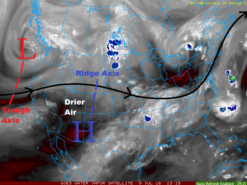
The lone exception to the rule will be across the far Northeast and Southeast Plains. The westerly flow aloft will promote the development of a lee surface trough across the eastern plains, near the CO/KS border. To the east of the trough axis, dewpoints will be in the 50s and 60s, while downsloping winds to the west drop dewpoints into the 30s. The surface convergence, combined with the strong instability, will force a couple isolated thunderstorms to develop, with the main threats being heavy rain, hail, lightning, and strong winds. Thus, the issuance of the low flood threat. For more details regarding timing and rain rates, please see the zone-specific discussions below.
Today’s Flood Threat Map
For more information on today’s flood threat, see the map below (hover over threat areas for more details). For Zone-Specific forecasts, jump below the map.

Zone-Specific Forecasts
Northern Mountains, Front Range, San Juan Mountains, Southeast Mountains, Urban Corridor, Palmer Ridge, and Raton Ridge:
Mostly sunny and warm in the high country, hot across the lower elevations. A few high-based, isolated showers/thunderstorms are possible over the higher terrain, resulting in mainly gusty winds and virga. A few sprinkles/light rain are possible, but the lack of moisture will keep it limited to that.
Timing: 1 PM – 9 PM
Northeast Plains and Southeast Plains:
Mostly sunny and hot for most, with isolated thunderstorms rumbling during the afternoon and evening hours near the eastern CO border. High temperatures will bump up a few degrees as compared to yesterday, and clearing skies overnight will allow for seasonably cool lows.
Northeast Plains: 1.5-2.0 inches/hour
Southeast Plains: 1.8-2.5 inches/hour
Timing: 2 PM – 10 PM
Northwest Slope, Grand Valley, Central Mountains, and Southwest Slope:
Mostly sunny and hot in the lower elevations, warm in the higher elevations. Fire danger is elevated today, and red flag warning have been issued for locations below 7,000 feet. Please, use extra caution when outside today and avoid burning as gusty winds, dry fuels, and heat make today dangerous.