Issue Date: 7/8/2016
Issue Time: 10:21 AM
LOW FLOOD THREAT IS FORECAST FOR PORTIONS OF THE URBAN CORRIDOR, NORTHEAST PLAINS, PALMER RIDGE, SOUTHEAST PLAINS, FRONT RANGE, AND RATON RIDGE.
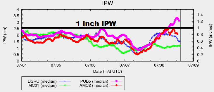
Ample moisture has backed into eastern Colorado in the wake of a cool front passed through last night. Surface dewpoints in the 50s and 60s can be found along and east of I-25. As you moved westward from I-25, moisture reduces quickly across the mountains, with dewpoints in the 20s/30s across far western portions of Colorado. The IPW chart below shows this stark divide in moisture, with Pueblo showing 1.2 inches of IPW while Grand Junction sits at just under 0.5 inches.
For today, the main story will be the unstable air mass in place over eastern Colorado, owing to the increased moisture and strong daytime heating. Wind shear will be sufficient to organize convective activity, and a few strong/severe storms are likely. These storms will be capable of heavy rain, large hail, and damaging winds. An isolated tornado or two cannot be ruled out, either. Additionally, with southeasterly surface flow expected, the presence of a Denver convergence zone is anticipated. This will provide a boundary for storms to develop over and propagate along, mainly over/near Douglas and Elbert counties, and should be monitored for strong/severe storms and potential flooding issues.
Over the High Country of the Northern Mountains, Central Mountains, San Juan Mountains, Front Range, and Southeast Mountains regions, scattered showers/thunderstorms are expected to develop around lunchtime, ending/moving east of the area by 8-9 PM. Further to the west, the Northwest Slope, Grand Valley, and Southwest Slope regions will stay hot and dry. Please see the zone-specific forecast discussions below for more details.
Today’s Flood Threat Map
For more information on today’s flood threat, see the map below (hover over threat areas for more details). For Zone-Specific forecasts, jump below the map.

Zone-Specific Forecasts
Urban Corridor, Northeast Plains, Southeast Plains, Palmer Ridge and Raton Ridge:
Isolated-to-scattered showers/thunderstorms expected. A few will be strong/severe, producing heavy rain, large hail, strong/damaging winds. As mentioned above, isolated tornadoes cannot be ruled out. Maximum rain rates are as follows:
Urban Corridor: 1.0-1.8 inches/hour
Palmer Ridge: 1.0-2.0 inches/hour
Northeast Plains and Southeast Plains: 1.8-3.0 inches/hour
Timing: 1 PM – Midnight
Northwest Slope, Southwest Slope, and Grand Valley:
Mostly sunny, hot, and dry is the weather story of today. Fuels will continue to dry out, enhancing fire concerns. High temperatures will be comparable to yesterday, with perhaps a degree or two of warming.
Northern Mountains, Central Mountains, Front Range, San Juan Mountains, Southeast Mountains, and San Luis Valley:
Scattered showers/thunderstorms expected this afternoon and evening, and most will be garden variety. The Front Range, especially southern portions near the deepest moisture, will hold the chance of one or two strong thunderstorms. These areas are outlined in the low flood threat. Maximum rain rates are as follows:
Northern Mountains and Central Mountains: 0.2-0.5 inches/hour
Southeast Mountains and San Juan Mountains: 0.4-0.6 inches/hour
Front Range: 0.8-1.4 inches/hour
San Luis Valley: 0.1-0.2 inches/hour
Timing: 11 AM – 9 PM