FTB 07-15-2016: Another Active Day in Store for Eastern Colorado

Issue Date: 7/15/2016
Issue Time: 9:20 AM

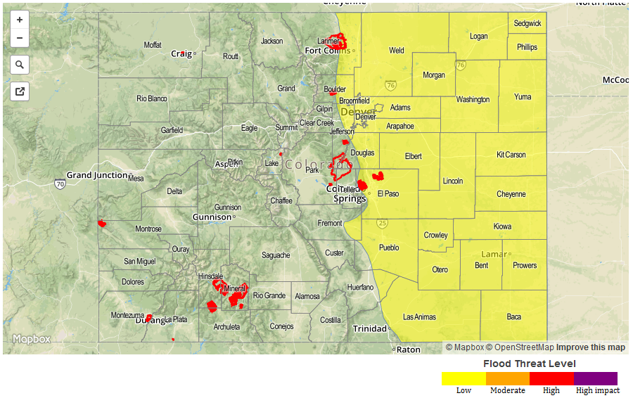
A LOW FLOOD THREAT IS FORECAST FOR PORTIONS OF THE FRONT RANGE, URBAN CORRIDOR, PALMER RIDGE, NORTHEAST PLAINS, SOUTHEAST PLAINS, AND RATON RIDGE.

It will be another active day across eastern Colorado, with the threat of strong/severe storms the main story. Dewpoints remain in the 50s and 60s across much of the Urban Corridor, Palmer Ridge, Northeast Plains, Southeast Plains, and Raton Ridge regions, which will leave plenty of fuel for this period’s thunderstorm activity. A reinforcing shot of moisture will come from the east/northeast this morning/early afternoon in the form of an outflow boundary from storms over Nebraska and Kansas. This moisture, combined with strong daytime heating, ample wind shear, steep mid-level lapse rates, and a mid-level disturbance will provide the support for strong/severe thunderstorms capable of producing large hail, damaging winds, periods of heavy rain, and an isolated tornado or two.

Sfc_20160715

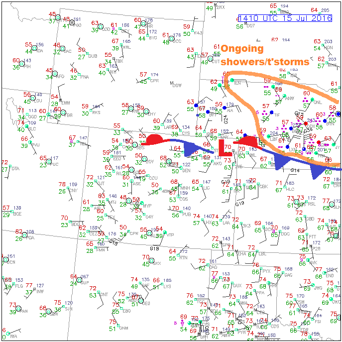
There will be a few more thunderstorms over the higher terrain, and further westward than previous days. The Front Range and Southeast Mountains will experience a similar day to yesterday, albeit with slightly more coverage expected. The San Juan Mountains, Northern Mountains, and Central Mountains will get in on isolated high-based showers/thunderstorms, but will receive very little rainfall. In general, any storm activity over these regions will produce mainly gusty winds and lightning, and perhaps a sprinkle or two. Further west, the fire danger is elevated, once again, as dry air, dry fuels, and gusty winds combine forces. For more information regarding rain rates and timing, please see the zone-specific forecast discussions below.

Today’s Flood Threat Map

For more information on today’s flood threat, see the map below (hover over threat areas for more details). For Zone-Specific forecasts, jump below the map.
FTB_20160716 Zone-Specific Forecasts

Urban Corridor, Palmer Ridge, Raton Ridge, Northeast Plains, and Southeast Plains:

Isolated-to-scattered showers/thunderstorms expected, and a few will be strong/severe. The main threats from any strong/severe thunderstorms will be large hail (up to 2.0 inches in diameter), strong winds (up to 60 mph), periods of heavy rain, and an isolated tornado or two. The most likely location for the stronger storms to develop will be over the Northeast Plains, Palmer Ridge, and Southeast Plains regions. If outflow boundaries can push far enough westward into the Urban Corridor, reinforcing deep moisture and easterly low-level flow, the threat for strong/severe storms will increase along the I-25 corridor. Maximum rain rates are as follows:

Urban Corridor: 0.8-1.5 inches/hour
Palmer Ridge and Raton Ridge: 1.0-2.0 inches/hour
Northeast Plains: 1.5-2.5 inches/hour
Southeast Plains: 2.0-3.0 inches/hour

Timing: Noon – 1 AM, with storms ending from west to east

Front Range and Southeast Mountains:

Isolated-to-scattered showers/thunderstorms expected. Most will be garden variety, but one or two will be strong. The main threats from storms will be gusty winds and lightning, with brief periods of moderate-to-heavy rainfall. Maximum rain rates will be 0.7-1.1 inches/hour.

Timing: 11 AM – 8 PM

Northern Mountains, San Juan Mountains, Northwest Slope, Grand Valley, Central Mountains, and Southwest Slope:

Isolated high-based showers/thunderstorms are expected over the higher terrain of the Northern Mountains, Central Mountains, and San Juan Mountains. Very little rainfall, if any, will result. Elsewhere, it will be hot and dry like previous days, with temperatures 4-6 degrees above normal. Fire danger is elevated, once again, so please be extra cautious.

Timing: 11 AM – 8 PM

FTB 07-14-2016: Isolated-to-Scattered Thunderstorms Expected

Issue Date: 7/14/2016
Issue Time: 9:59 AM

A LOW FLOOD THREAT IS FORECAST FOR PORTIONS OF THE PALMER RIDGE, NORTHEAST PLAINS, SOUTHEAST PLAINS, RATON RIDGE, AND URBAN CORRIDOR.

For areas along and west of the Continental Divide, today’s forecast is going to be similar to the previous few days. IPW has remained steady, but low, in the bottom 25th percentile for this time of year. While the other three normal reporting stations have fluctuated with low-level moisture surges, no such luck has occurred for the High Country and Western Slope. This will be the case again today, with warm and dry conditions expected. A bit more mid-level moisture will hang overhead today, however, so a few more clouds will result.

IPW_20160714

East of the Divide, isolated-to-scattered thunderstorms are expected this afternoon and into the overnight hours. A weak disturbance embedded in the west/northwest flow aloft will traverse the state, combining with low-level moisture and daytime heating to kick off the activity. Showers/thunderstorms will initially develop over the Front Range and Southeast Mountains, moving in a general east-southeast direction.

Modest wind shear values will help organize storms, with a couple becoming strong/severe. The bulk of thunderstorm activity will occur over the Palmer Ridge, Raton Ridge, and Southeast Plains, with more isolated coverage across the Northeast Plains and Urban Corridor. For more information regarding timing and rain rates, please see the zone-specific forecast discussions below.

Today’s Flood Threat Map

For more information on today’s flood threat, see the map below (hover over threat areas for more details). For Zone-Specific forecasts, jump below the map.

Flood Threat Legend

Zone-Specific Forecasts

Urban Corridor, Northeast Plains, Southeast Plains, Palmer Ridge and Raton Ridge:

Isolated-to-scattered showers and thunderstorms are expected today and tonight, with the bulk of activity occurring across the Palmer Ridge, Southeast Plains, and Raton Ridge regions. A few storms will become strong/severe, with the main threats being hail (1-1.5 inches in diameter), strong winds (up to 60 mph), lightning, and periods of moderate/heavy rain. Maximum rain rates are as follows:

Urban Corridor: 0.8-1.4 inches/hour
Northeast Plains: 1.4-2.0 inches/hour
Southeast Plains and Palmer Ridge: 2.0-2.5 inches/hour
Raton Ridge: 1.0-1.8 inches/hour

Timing: 1 PM – Midnight, with one or two showers/storms lingering into the early morning hours

Front Range and Southeast Mountains:

Isolated showers/thunderstorms are expected this afternoon/evening, moving east-southeastward with time. Rain rates are expected to be modest, with the best moisture sitting east over the lower elevations. Maximum rain rates are 0.3-0.7 inches/hour for the Front Range, and 0.4-0.8 inches/hour for the Southeast Mountains.

Timing: Noon – 9 PM

Northwest Slope, Northern Mountains, Central Mountains, Grand Valley, San Juan Mountains, Southwest Slope, and San Luis Valley:

Mostly sunny and warm, with continued dry conditions. Winds will be less breezy today, allowing fire danger to relax a bit. High temperatures will be a degree or two warmer than yesterday. A few more clouds will be seen in the sky over the higher terrain, thanks to a bit more moisture in the mid-levels.

FTB 07-13-2016: Similar Conditions to Yesterday, with Subtle Differences

Issue Date: 7/13/2016
Issue Time: 10:03 AM

A LOW FLOOD THREAT IS FORECAST FOR PORTIONS OF THE PALMER RIDGE, NORTHEAST PLAINS, PALMER RIDGE, SOUTHEAST PLAINS, AND URBAN CORRIDOR.

Today’s forecast will be a near “rinse and repeat” of yesterday’s forecast, especially for the High Country and Western Slope. Dry, westerly flow aloft will continue throughout today, with gusty winds bringing about another day of elevated fire danger across northern Colorado. Red Flag Warnings have been issued for portions of the Front Range, Northern Mountains, and Northwest Slope. The consistently dry air is easy to pick out in the IPW graph below. The green line represents Grand Junction, which has remained steady beneath 0.4 inches since Monday evening.

IPW_20160713

East of the mountains, the forecast will largely be the same as yesterday’s, with high temperatures near, or just above, yesterday’s maximums. Additionally, another moisture surge is expected later this afternoon/tonight, just as the previous two nights (marked by #1 and #2 in the IPW graph), as east-southeasterly flow returns. The upslope component, combined with strong daytime heating and steep mid-level lapse rates, will overcome the relatively neutral upper-levels, leading to a few isolated thunderstorms this afternoon and into the nighttime hours. Not much coverage is expected, and likelihood of occurrence is low (~25%), but the potential is there. As we have seen the last two forecast periods, if you give Mother Nature an inch, she will take a mile. For more details regarding timing and rain rates, please see the zone-specific discussions below.

Today’s Flood Threat Map

For more information on today’s flood threat, see the map below (hover over threat areas for more details). For Zone-Specific forecasts, jump below the map.

Flood Threat Legend

Zone-Specific Forecasts

Urban Corridor, Northeast Plains, Southeast Plains, Palmer Ridge and Raton Ridge:

Similar to yesterday, with most locations experiencing mostly sunny skies and dry conditions. High temperatures today will be near yesterday’s readings, with a few locations coming in a few degrees warmer. There is the risk for isolated thunderstorms across the Northeast Plains, Southeast Plains, and Palmer Ridge from this afternoon into the early morning hours. Southern portions of the Urban Corridor could get in on the action, if the moisture surge and associated surface boundary can get there. Training isolated thunderstorms are a concern, as they attempt to stay anchored to the surface boundary, moving eastward due to westerly flow aloft. A couple storms will be strong-to-severe, with the main threats being hail, strong winds, and periods of heavy rain. Maximum rain rates are as follows:

Urban Corridor: 1.0-1.8 inches/hour
Northeast Plains, Southeast Plains, and Palmer Ridge: 1.5-2.5 inches/hour

Timing: 2 PM – 4 AM

Northwest Slope, Northern Mountains, Central Mountains, Grand Valley, Front Range, San Juan Mountains, Southwest Slope, Southeast Mountains, and San Luis Valley:

Mostly sunny and dry, with gusty winds elevating fire concerns. Red Flag Warnings have been issued for portions of the Front Range, Northern Mountains, and Northwest Slope due to expected gusty conditions, dry fuels, and low relative humidity. Further south, gusty winds will be felt at times, but not to the extent of the northern zones.

FTB 07-12-2016: Warmer with a Low Chance of Thunderstorms

Issue Date: 7/12/2016
Issue Time: 9:24 AM

NO FLOOD THREAT IS FORECAST.

The forecast today will only be a slight modification of yesterday’s, with the main change being slightly warmer temperatures. Dry, westerly flow aloft continues across Colorado, bringing gusty conditions to the higher terrain. Lower elevations of the Northern Mountains and Northwest Slope be the focus for elevated fire danger today, as low relative humidity and dry fuels combine with the gusty winds. Red Flag Warnings have been issued, so please check with your local NWS office for more details.

A similarity to yesterday will be the slight chance for isolated thunderstorms across Eastern Colorado, mainly eastern portions of the Northeast Plains, Palmer Ridge, Raton Ridge, and Southeast Plains. In the IPW image below, you can see the modest moisture “surge” responsible for fueling yesterday’s (continuing into this morning) thunderstorms. A similar moisture surge will occur again this afternoon/evening, albeit not as robust, as winds turn south-southeasterly, pulling just a bit of Gulf moisture into eastern Colorado.

IPW_20160712

Tempering today’s thunderstorm chances is a bit of convergence aloft, thanks to the positioning of an upper-level jet streak. This will work against thunderstorm development, keeping coverage more isolated than yesterday. With that being said, any storms that form will have access to modest instability/wind shear, so one or two strong-to-marginally severe thunderstorms cannot be ruled out. For more details regarding timing and rain rates, please see the zone-specific forecast discussions below.

Today’s Flood Threat Map

For more information on today’s flood threat, see the map below (hover over threat areas for more details). For Zone-Specific forecasts, jump below the map.

Flood Threat Legend

Zone-Specific Forecasts

Urban Corridor, Northeast Plains, Southeast Plains, Palmer Ridge and Raton Ridge:

Mostly sunny and dry for the majority of the area, with high temperatures climbing a few degrees higher than yesterday. A couple isolated thunderstorms cannot be ruled out across eastern portions of the Northeast Plains, Palmer Ridge, Raton Ridge, and Southeast Plains. Probability of occurrence is low (20%); the upper-levels will be restrictive with weak convergence aloft, so it will take Mother Nature doing her best with the least to produce any thunderstorms. Maximum rain rates from this scenario are 1.0-1.6 inches/hour.

During the evening/nighttime hours, it will be important to monitor outflow boundaries from any thunderstorms. There is a non-zero chance that an outflow boundary backs into the Urban Corridor or western portions of the Southeast Plains/Raton Ridge, sparking an isolated thunderstorm or two. Probability of occurrence for this scenario is 10%. Maximum rain rates from this scenario are 0.4-0.8 inches/hour.

Timing: 2 PM – 2 AM

Northwest Slope, Northern Mountains, Central Mountains, Grand Valley, Front Range, San Juan Mountains, Southwest Slope, Southeast Mountains, and San Luis Valley:

Sunny and dry, with temperatures climbing a few degrees higher than yesterday. Red Flag Warnings have been issued for portions of the Northwest Slope and Northern Mountains, owing to the dry conditions and gusty winds. Overnight lows will be similar to last night’s lows, perhaps a degree or two warmer.