Issue Date: 7/14/2016
Issue Time: 9:59 AM
A LOW FLOOD THREAT IS FORECAST FOR PORTIONS OF THE PALMER RIDGE, NORTHEAST PLAINS, SOUTHEAST PLAINS, RATON RIDGE, AND URBAN CORRIDOR.
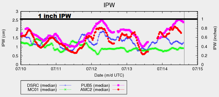
For areas along and west of the Continental Divide, today’s forecast is going to be similar to the previous few days. IPW has remained steady, but low, in the bottom 25th percentile for this time of year. While the other three normal reporting stations have fluctuated with low-level moisture surges, no such luck has occurred for the High Country and Western Slope. This will be the case again today, with warm and dry conditions expected. A bit more mid-level moisture will hang overhead today, however, so a few more clouds will result.
East of the Divide, isolated-to-scattered thunderstorms are expected this afternoon and into the overnight hours. A weak disturbance embedded in the west/northwest flow aloft will traverse the state, combining with low-level moisture and daytime heating to kick off the activity. Showers/thunderstorms will initially develop over the Front Range and Southeast Mountains, moving in a general east-southeast direction.
Modest wind shear values will help organize storms, with a couple becoming strong/severe. The bulk of thunderstorm activity will occur over the Palmer Ridge, Raton Ridge, and Southeast Plains, with more isolated coverage across the Northeast Plains and Urban Corridor. For more information regarding timing and rain rates, please see the zone-specific forecast discussions below.
Today’s Flood Threat Map
For more information on today’s flood threat, see the map below (hover over threat areas for more details). For Zone-Specific forecasts, jump below the map.

Zone-Specific Forecasts
Urban Corridor, Northeast Plains, Southeast Plains, Palmer Ridge and Raton Ridge:
Isolated-to-scattered showers and thunderstorms are expected today and tonight, with the bulk of activity occurring across the Palmer Ridge, Southeast Plains, and Raton Ridge regions. A few storms will become strong/severe, with the main threats being hail (1-1.5 inches in diameter), strong winds (up to 60 mph), lightning, and periods of moderate/heavy rain. Maximum rain rates are as follows:
Urban Corridor: 0.8-1.4 inches/hour
Northeast Plains: 1.4-2.0 inches/hour
Southeast Plains and Palmer Ridge: 2.0-2.5 inches/hour
Raton Ridge: 1.0-1.8 inches/hour
Timing: 1 PM – Midnight, with one or two showers/storms lingering into the early morning hours
Front Range and Southeast Mountains:
Isolated showers/thunderstorms are expected this afternoon/evening, moving east-southeastward with time. Rain rates are expected to be modest, with the best moisture sitting east over the lower elevations. Maximum rain rates are 0.3-0.7 inches/hour for the Front Range, and 0.4-0.8 inches/hour for the Southeast Mountains.
Timing: Noon – 9 PM
Northwest Slope, Northern Mountains, Central Mountains, Grand Valley, San Juan Mountains, Southwest Slope, and San Luis Valley:
Mostly sunny and warm, with continued dry conditions. Winds will be less breezy today, allowing fire danger to relax a bit. High temperatures will be a degree or two warmer than yesterday. A few more clouds will be seen in the sky over the higher terrain, thanks to a bit more moisture in the mid-levels.