Issue Date: 7/12/2016
Issue Time: 9:24 AM
NO FLOOD THREAT IS FORECAST.
The forecast today will only be a slight modification of yesterday’s, with the main change being slightly warmer temperatures. Dry, westerly flow aloft continues across Colorado, bringing gusty conditions to the higher terrain. Lower elevations of the Northern Mountains and Northwest Slope be the focus for elevated fire danger today, as low relative humidity and dry fuels combine with the gusty winds. Red Flag Warnings have been issued, so please check with your local NWS office for more details.
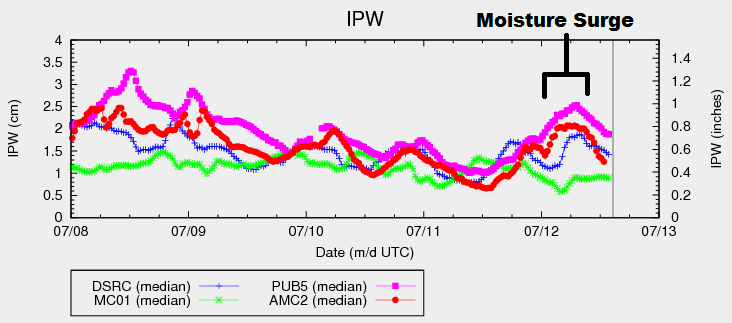
A similarity to yesterday will be the slight chance for isolated thunderstorms across Eastern Colorado, mainly eastern portions of the Northeast Plains, Palmer Ridge, Raton Ridge, and Southeast Plains. In the IPW image below, you can see the modest moisture “surge” responsible for fueling yesterday’s (continuing into this morning) thunderstorms. A similar moisture surge will occur again this afternoon/evening, albeit not as robust, as winds turn south-southeasterly, pulling just a bit of Gulf moisture into eastern Colorado.
Tempering today’s thunderstorm chances is a bit of convergence aloft, thanks to the positioning of an upper-level jet streak. This will work against thunderstorm development, keeping coverage more isolated than yesterday. With that being said, any storms that form will have access to modest instability/wind shear, so one or two strong-to-marginally severe thunderstorms cannot be ruled out. For more details regarding timing and rain rates, please see the zone-specific forecast discussions below.
Today’s Flood Threat Map
For more information on today’s flood threat, see the map below (hover over threat areas for more details). For Zone-Specific forecasts, jump below the map.

Zone-Specific Forecasts
Urban Corridor, Northeast Plains, Southeast Plains, Palmer Ridge and Raton Ridge:
Mostly sunny and dry for the majority of the area, with high temperatures climbing a few degrees higher than yesterday. A couple isolated thunderstorms cannot be ruled out across eastern portions of the Northeast Plains, Palmer Ridge, Raton Ridge, and Southeast Plains. Probability of occurrence is low (20%); the upper-levels will be restrictive with weak convergence aloft, so it will take Mother Nature doing her best with the least to produce any thunderstorms. Maximum rain rates from this scenario are 1.0-1.6 inches/hour.
During the evening/nighttime hours, it will be important to monitor outflow boundaries from any thunderstorms. There is a non-zero chance that an outflow boundary backs into the Urban Corridor or western portions of the Southeast Plains/Raton Ridge, sparking an isolated thunderstorm or two. Probability of occurrence for this scenario is 10%. Maximum rain rates from this scenario are 0.4-0.8 inches/hour.
Timing: 2 PM – 2 AM
Northwest Slope, Northern Mountains, Central Mountains, Grand Valley, Front Range, San Juan Mountains, Southwest Slope, Southeast Mountains, and San Luis Valley:
Sunny and dry, with temperatures climbing a few degrees higher than yesterday. Red Flag Warnings have been issued for portions of the Northwest Slope and Northern Mountains, owing to the dry conditions and gusty winds. Overnight lows will be similar to last night’s lows, perhaps a degree or two warmer.