Issue Date: 7/13/2016
Issue Time: 10:03 AM
A LOW FLOOD THREAT IS FORECAST FOR PORTIONS OF THE PALMER RIDGE, NORTHEAST PLAINS, PALMER RIDGE, SOUTHEAST PLAINS, AND URBAN CORRIDOR.
Today’s forecast will be a near “rinse and repeat” of yesterday’s forecast, especially for the High Country and Western Slope. Dry, westerly flow aloft will continue throughout today, with gusty winds bringing about another day of elevated fire danger across northern Colorado. Red Flag Warnings have been issued for portions of the Front Range, Northern Mountains, and Northwest Slope. The consistently dry air is easy to pick out in the IPW graph below. The green line represents Grand Junction, which has remained steady beneath 0.4 inches since Monday evening.
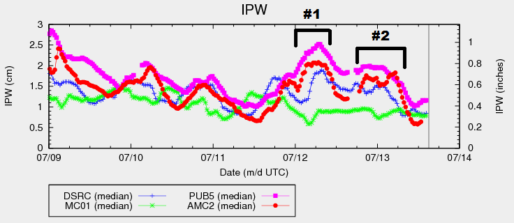
East of the mountains, the forecast will largely be the same as yesterday’s, with high temperatures near, or just above, yesterday’s maximums. Additionally, another moisture surge is expected later this afternoon/tonight, just as the previous two nights (marked by #1 and #2 in the IPW graph), as east-southeasterly flow returns. The upslope component, combined with strong daytime heating and steep mid-level lapse rates, will overcome the relatively neutral upper-levels, leading to a few isolated thunderstorms this afternoon and into the nighttime hours. Not much coverage is expected, and likelihood of occurrence is low (~25%), but the potential is there. As we have seen the last two forecast periods, if you give Mother Nature an inch, she will take a mile. For more details regarding timing and rain rates, please see the zone-specific discussions below.
Today’s Flood Threat Map
For more information on today’s flood threat, see the map below (hover over threat areas for more details). For Zone-Specific forecasts, jump below the map.

Zone-Specific Forecasts
Urban Corridor, Northeast Plains, Southeast Plains, Palmer Ridge and Raton Ridge:
Similar to yesterday, with most locations experiencing mostly sunny skies and dry conditions. High temperatures today will be near yesterday’s readings, with a few locations coming in a few degrees warmer. There is the risk for isolated thunderstorms across the Northeast Plains, Southeast Plains, and Palmer Ridge from this afternoon into the early morning hours. Southern portions of the Urban Corridor could get in on the action, if the moisture surge and associated surface boundary can get there. Training isolated thunderstorms are a concern, as they attempt to stay anchored to the surface boundary, moving eastward due to westerly flow aloft. A couple storms will be strong-to-severe, with the main threats being hail, strong winds, and periods of heavy rain. Maximum rain rates are as follows:
Urban Corridor: 1.0-1.8 inches/hour
Northeast Plains, Southeast Plains, and Palmer Ridge: 1.5-2.5 inches/hour
Timing: 2 PM – 4 AM
Northwest Slope, Northern Mountains, Central Mountains, Grand Valley, Front Range, San Juan Mountains, Southwest Slope, Southeast Mountains, and San Luis Valley:
Mostly sunny and dry, with gusty winds elevating fire concerns. Red Flag Warnings have been issued for portions of the Front Range, Northern Mountains, and Northwest Slope due to expected gusty conditions, dry fuels, and low relative humidity. Further south, gusty winds will be felt at times, but not to the extent of the northern zones.