FTB 07-19-2016: Monsoonal Moisture Continues to Flow into Colorado

Issue Date: 7/19/2016
Issue Time: 9:40 AM

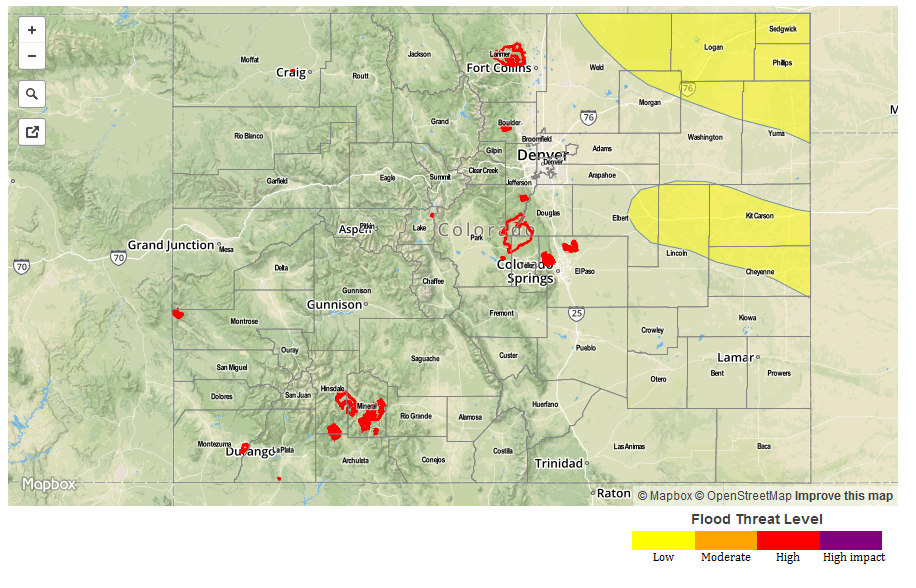
A MODERATE FLOOD THREAT IS ISSUED FOR PORTIONS OF THE SOUTHWEST SLOPE, SAN JUAN MOUNTAINS, AND CENTRAL MOUNTAINS.

A LOW FLOOD THREAT IS FORECAST FOR SURROUNDING AREAS, INCLUDING PORTIONS OF THE NORTHERN MOUNTAINS, GRAND VALLEY, NORTHWEST SLOPE, FRONT RANGE, URBAN CORRIDOR, AND NORTHEAST PLAINS.

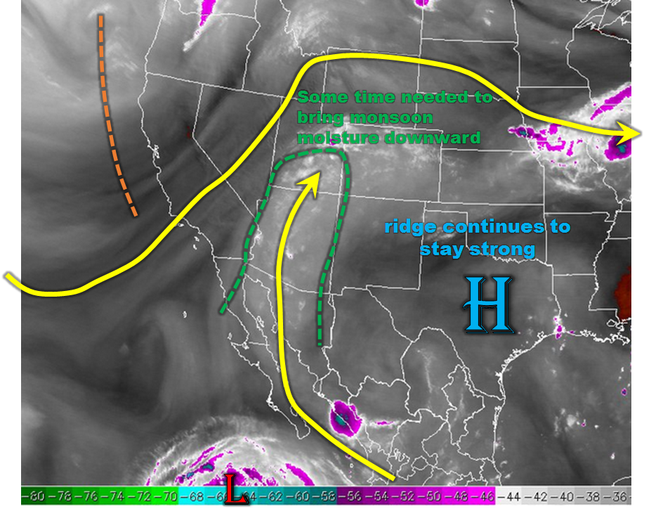
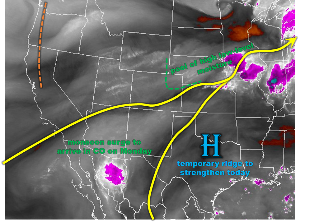
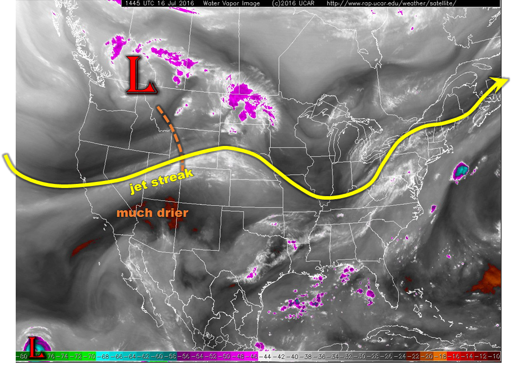
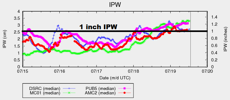
Current water vapor analysis shows a strong, upper-level high centered over the south-central US and an upper-level low spinning just off the coast of the Pacific Northwest. These two features have created a pathway for monsoonal moisture to flow into Colorado, pushing IPW values above 1 inch at all four of the normal reporting stations (Grand Junction, Boulder, Pueblo, and Schriever AFB, shown below). This amount of moisture will create an environment in which heavy rain is possible, thus the issuance of the flood threats today.

IPW_20160719

There are still a few showers/thunderstorms ongoing across western Colorado this morning, owing to a weak disturbance passing through in the mid-level flow. As the day wears on, showers/thunderstorms will increase in coverage over the High Country and Western Slope, generally moving to the northeast with the mean flow. Localized heavy rainfall, gusty winds, and lightning will be the main threats with any of this activity.

Further to the east, scattered showers/storms will move off the mountains and across adjacent lower elevations of eastern Colorado during the afternoon and evening. This activity will first appear just after lunchtime, and continue until 8-9 PM, diminishing fairly quickly and ending by 10 PM. Localized heavy rainfall, gusty winds, and lightning will be the main threats.

Much of the Southeast Plains and Raton Ridge will remain dry, as well as southeastern extents of the Northeast Plains. For those areas, the mid- and upper-levels will not be supportive of developing thunderstorms, and the mean flow will take thunderstorms that develop over the mountains to the north and west of the area.

For more information, including rain rates and timing, please see the zone-specific forecast discussions below.

Today’s Flood Threat Map

For more information on today’s flood threat, see the map below (hover over threat areas for more details). For Zone-Specific forecasts, jump below the map.

Flood Threat Legend

Zone-Specific Forecasts

Urban Corridor, Northeast Plains, and Palmer Ridge:

Scattered showers/thunderstorms will move off of the mountains and overhead during the afternoon and evening hours. Locations along and near the higher terrain will hold the best chance at seeing this activity. Southeastern portions of the Northeast Plains and far eastern portions of the Palmer Ridge will likely stay dry today, with the mean flow pushing storms across areas to the north and west. Maximum rain rates will be 0.8-1.2 inches/hour.

Timing: 1 PM – 10 PM

Southeast Plains and Raton Ridge:

Western extents of these regions will see a couple isolated showers/thunderstorms this afternoon/evening as they move off of the mountains. To the east, the area will stay dry and mostly sunny, with highs reaching into the 90s and near 100 F. Brief moderate-to-heavy rain, gusty winds, and lightning will attend thunderstorms. Maximum rain rates will be 0.4-0.8 inches/hour.

Timing: 1 PM – 11 PM

Front Range, Southeast Mountains, Northwest Slope, Northern Mountains, and San Luis Valley:

Scattered showers/thunderstorms are expected this afternoon/evening, diminishing between 9 PM and Midnight. Locally heavy rainfall, gusty winds, and lightning will be the main threats. Maximum rain rates are as follows:

Front Range: 1.2-1.8 inches/hour
Southeast Mountains: 0.4-0.6 inches/hour
Northwest Slope: 0.4-0.7 inches/hour
Northern Mountains: 1.0-1.5 inches/hour
San Luis Valley: 0.4-0.8 inches/hour

Timing: 11 AM – Midnight

Central Mountains, Grand Valley, San Juan Mountains, and Southwest Slope:

Scattered showers/thunderstorms are expected this afternoon/evening, with a few showers/storms continuing through the overnight hours and into tomorrow morning. Locally heavy rainfall, gusty winds, and lightning will be the main threats. Multiple rounds of locally heavy rainfall are a concern, and the reason for the issuance of the moderate flood threat. Flash flooding, mud/debris flows, urban ponding, etc. are threats from heavy rainfall. The maximum rain rate is 1.2-1.8 inches/hour.

Timing: 11 AM – 6 AM

FTB 07-18-2016: Day 1 of monsoon-fed storms

Issue Date: Monday, July 18, 2016
Issue Time: 11:00AM MDT

MODERATE flood threat for parts of Northeast Plains and Palmer Ridge
MODERATE flood threat for parts of San Juans
LOW flood threat for parts of Grand Valley Southwest Slope and Central Mountains
LOW flood threat for parts of Front Range and Urban Corridor
— If necessary, an updated threat map may be posted by 3PM today

As expected and shown in the water vapor image, below, the first significant push of monsoonal moisture is currently rounding its way northward into the four corners region. The precipitable water (PW) in Grand Junction has gone from below 0.4 inches to near 1 inch in about 36 hours. Comparing this morning’s Grand Junction sounding with yesterday mornings (below) undoubtedly shows the increase in moisture. However, most of the increase is currently well above the boundary layer and will take most of today to make it downward where it can have an impact on heavy rainfall. Guidance suggests that the southwest part of the state will be most vulnerable to this, especially after convection farther southwest organizes into larger segments. A moderate flood threat is warranted.

While moisture is clearly not a limiting factor today, the atmospheric dynamics are. A strong ridge, an extension of the Bermuda High, continues to stay put or strengthen across the southeast part of the United States. This will play a mainly negative factor in rainfall rates east of the Divide by (i) increasing mid-level temperatures (at Denver, mid-level temps have increased by 3-5F over the last 24-hours, and (ii) promoting downsloping flow that will tend to limit strong storms in the higher terrain and foothills. Nonetheless, farther east, the high instability will result in at least one round of storms capable of producing very heavy rainfall. A moderate flood threat has been posted.

wv_markupGJT_soundingToday’s Flood Threat Map

For more information on today’s flood threat, see the map below (hover over threat areas for more details). For Zone-Specific forecasts, scroll below the map.

Flood Threat Legend

Zone-Specific Forecasts:

San Juan Mountains, Northern Mountains, Grand Valley, Northwest Slope, Southwest Slope, Central Mountains:

Partly to mostly cloudy early with scattered showers evolving into scattered to widespread thunderstorms. Highest coverage will be in southern areas. Max 1-hr rain rates up to 1.2 inches, and 3-hr rain rates up to 2.1 inches are possible. Isolated flash flooding is possible, along with debris slides and mud flows. A wave of higher rainfall rates could move northeast out of New Mexico and affect the southwest facing slopes of the San Juans in the late evening. Thus, a moderate flood threat has been posted for parts of the area, with a Low threat surrounding that.

Primetime: Noon to 3AM

Front Range, Urban Corridor, Northeast Plains, Palmer Ridge:

Mostly sunny early then scattered to widespread thunderstorms forming by early afternoon. Highest coverage will be in the east Urban Corridor and Northeast Plains. However, at least isolated storms will be possible in this whole region. Max 1-hour rain rates up to 2.4 inches are possible, with isolated 3-hour rain rates up to 3.4 inches. Hail up to 1.25 inches is possible with the strongest cells. A moderate flood threat has been posted for parts of the region for flash flooding, road and field flooding as well as debris slides and mud flows in the higher terrain.

Primetime: 1pm to 1am (for far east areas)

Southeast Mountains, Raton Ridge, Southeast Plains, San Luis Valley:

Sunny early then turning partly cloudy and much cooler. Isolated to scattered thunderstorms are possible, mostly for eastern areas. Max 1-hour rain rates up to 1 inch are possible. Flooding is not expected today.

Primetime: 1pm to 8pm

FTB 07-17-2016: Flood Threat Returns Across East; Fire Threat Remains Across West

Issue Date: Sunday, July 17, 2017
Issue Time: 10:40AM MDT

LOW flood threat for parts of Northeast Plains and Palmer Ridge

This morning’s water vapor image, shown below, shows a large-scale ridge will dominate Colorado’s weather today. The ridge is centered over Texas this morning, but will expand to affect a broad swath of real estate from Colorado all the way to the southeast Atlantic seaboard. The strengthening ridge will prevent large-scale rainfall for us, but that will not preclude scattered thunderstorm activity in favored regions. To determine those regions, we look at the morning’s moisture profile to find deeper moisture in the Northeast Plains extending southward along the Kansas border. Precipitable water values are as high as 1.2 inches in those regions and will stay that way through the day. Meanwhile, a residual surface circulation is noted across western KS. Although this circulation will dissipate through the day, it will focus a plume of higher moisture that will be directed towards northeast Colorado. Thus, as peak heating initiates the high-elevation trough, we expect isolated to widely scattered thunderstorms to be mostly limited to the Northeast Plains today. With high moisture in place, max 1-hour rain rates up to 2.0 inches will be possible. A Low flood threat is in place for parts of the area for isolated roadway and field flooding.

For areas farther west, the wildfire threat will continue today as afternoon relative humidity values will remain low. For today, wind speeds are expected to be weaker than yesterday, thus the overall threat will be lower but still exists.

wv_markup

Today’s Flood Threat Map

For more information on today’s flood threat, see the map below (hover over threat areas for more details). For Zone-Specific forecasts, scroll below the map.
FTB_20160717

Zone-Specific Forecasts:

Southeast Plains, Northeast Plains, Palmer Ridge:

Sunny early then turning partly cloudy with isolated to scattered thunderstorms forming by early afternoon and lasting through the early evening. Highest coverage will be towards the Wyoming border. Max 1-hour rain rates up to 2.0 inches will be possible, leading to isolated roadway and field flooding. Hail up to 1.5 inches will be possible, along with wind speeds up to 60 mph. A Low flood threat has been posted for parts of the region.

Primetime: 2pm to 9pm

Southeast Mountains, Raton Ridge, Urban Corridor, Front Range:

Sunny early then turning partly cloudy and continued hot. An isolated thunderstorm will be possible across the northern and eastern areas from the early afternoon to the early evening. Max 1-hour rain rates up to 0.8 inch will be possible. Gusty winds up to 50 mph will accompany the strongest cells. Flooding is not expected today.

Primetime: 1pm to 7pm

San Juan Mountains, San Luis Valley, Northern Mountains, Grand Valley, Northwest Slope, Southwest Slope, Central Mountains:

Mostly sunny and continued hot. The main story continues to be the elevated wildfire threat across the region as low humidity values will combine with gusty winds for the afternoon hours. Wind speeds today will be weaker than yesterday, so the fire threat is lower. However, a Red Flag Warning remains in effect for many areas. Stay tuned to NWS forecasts for local details. Flooding is not expected today.

FTB 07-16-2016: Drier Statewide; Very High Fire Risk For Higher Terrain

Issue Date: Saturday, July 16th, 2016
Issue Time: 9:00AM

— Flooding is NOT expected today

This morning’s water vapor image, below, shows a strong large-scale disturbance centered on the northwest US. It is accompanied by a moderate intensity jet streak that is positioned along the WY/CO border extended west-southwestward. This area of 60+ mph upper-level winds will usher in much drier air statewide. Some residual moisture is found this morning east of the Divide, especially near the surface. Slightly deeper moisture is found eastwards towards the KS border. It is likely that most of the deeper moisture will mix out before the atmosphere has time to generate strong thunderstorms. Thus, while isolated to widely scattered storms will be possible in the Front Range and Northeast Plains, heavy rainfall is not expected today. Thus, there is no flood threat.

wv_markupThe far bigger story today will be a very high wildfire risk for the higher terrain and western slope. Relative humidity values are expected to drop below 20% across many areas, along with gusty winds as strong solar heating causes downward momentum transport from the overhead jet streak. Ongoing fires will be vulnerable, while new fires are possible especially from dry lightning.

Today’s Flood Threat Map

For more information on today’s flood threat, see the map below (hover over threat areas for more details). For Zone-Specific forecasts, scroll below the map.
FTB_20160622Zone-Specific Forecasts:

Southeast Mountains, Raton Ridge, Palmer Ridge, Southeast Plains, Northeast Plains, Urban Corridor, Front Range:

Mostly sunny and hot with some high clouds streaming through during the late morning and afternoon. An isolated to widely scattered storm is possible in the Front Range and in the Northeast Plains. Maximum 1-hour rain rates up to 0.8 inch will be possible in eastern areas, and up to 0.4 inches closer to the mountains. Gusty winds up to 60 mph could accompany some of the strongest storms. Flooding is not expected today. A very high wildfire threat is in effect today for the foothills and higher terrain. A Red Flag warning is in effect for parts of the region. Stay tuned to NWS forecasts for local details.

San Juan Mountains, San Luis Valley, Northern Mountains, Grand Valley, Northwest Slope, Southwest Slope, Central Mountains:

Mostly sunny and hot with some high clouds possible, especially in northern areas. The big story today will be the very high wildfire threat across the region as low humidity values will combine with gusty winds for the afternoon hours. An isolated storm cannot be ruled out in the Northern and Central Mountains before dry air overwhelms their formation. Max 1-hour rain rates up to 0.2 inches possible, but the bigger threat will be lightning strikes and gusty winds. A Red Flag Warning is in effect for many areas. Stay tuned to NWS forecasts for local details.