Issue Date: Monday, July 18, 2016
Issue Time: 11:00AM MDT
— MODERATE flood threat for parts of Northeast Plains and Palmer Ridge
— MODERATE flood threat for parts of San Juans
— LOW flood threat for parts of Grand Valley Southwest Slope and Central Mountains
— LOW flood threat for parts of Front Range and Urban Corridor
— If necessary, an updated threat map may be posted by 3PM today
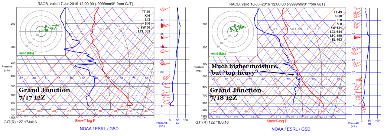
As expected and shown in the water vapor image, below, the first significant push of monsoonal moisture is currently rounding its way northward into the four corners region. The precipitable water (PW) in Grand Junction has gone from below 0.4 inches to near 1 inch in about 36 hours. Comparing this morning’s Grand Junction sounding with yesterday mornings (below) undoubtedly shows the increase in moisture. However, most of the increase is currently well above the boundary layer and will take most of today to make it downward where it can have an impact on heavy rainfall. Guidance suggests that the southwest part of the state will be most vulnerable to this, especially after convection farther southwest organizes into larger segments. A moderate flood threat is warranted.
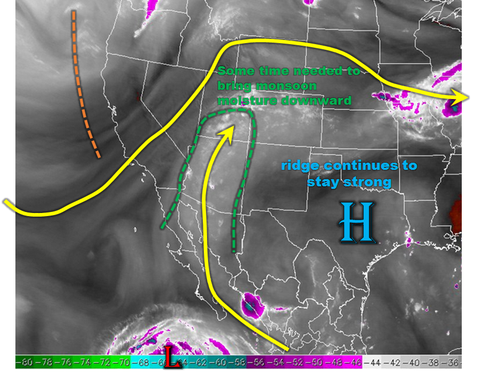
While moisture is clearly not a limiting factor today, the atmospheric dynamics are. A strong ridge, an extension of the Bermuda High, continues to stay put or strengthen across the southeast part of the United States. This will play a mainly negative factor in rainfall rates east of the Divide by (i) increasing mid-level temperatures (at Denver, mid-level temps have increased by 3-5F over the last 24-hours, and (ii) promoting downsloping flow that will tend to limit strong storms in the higher terrain and foothills. Nonetheless, farther east, the high instability will result in at least one round of storms capable of producing very heavy rainfall. A moderate flood threat has been posted.
 Today’s Flood Threat Map
For more information on today’s flood threat, see the map below (hover over threat areas for more details). For Zone-Specific forecasts, scroll below the map.

Zone-Specific Forecasts:
San Juan Mountains, Northern Mountains, Grand Valley, Northwest Slope, Southwest Slope, Central Mountains:
Partly to mostly cloudy early with scattered showers evolving into scattered to widespread thunderstorms. Highest coverage will be in southern areas. Max 1-hr rain rates up to 1.2 inches, and 3-hr rain rates up to 2.1 inches are possible. Isolated flash flooding is possible, along with debris slides and mud flows. A wave of higher rainfall rates could move northeast out of New Mexico and affect the southwest facing slopes of the San Juans in the late evening. Thus, a moderate flood threat has been posted for parts of the area, with a Low threat surrounding that.
Primetime: Noon to 3AM
Front Range, Urban Corridor, Northeast Plains, Palmer Ridge:
Mostly sunny early then scattered to widespread thunderstorms forming by early afternoon. Highest coverage will be in the east Urban Corridor and Northeast Plains. However, at least isolated storms will be possible in this whole region. Max 1-hour rain rates up to 2.4 inches are possible, with isolated 3-hour rain rates up to 3.4 inches. Hail up to 1.25 inches is possible with the strongest cells. A moderate flood threat has been posted for parts of the region for flash flooding, road and field flooding as well as debris slides and mud flows in the higher terrain.
Primetime: 1pm to 1am (for far east areas)
Southeast Mountains, Raton Ridge, Southeast Plains, San Luis Valley:
Sunny early then turning partly cloudy and much cooler. Isolated to scattered thunderstorms are possible, mostly for eastern areas. Max 1-hour rain rates up to 1 inch are possible. Flooding is not expected today.
Primetime: 1pm to 8pm