Issue Date: Sunday, July 17, 2017
Issue Time: 10:40AM MDT
— LOW flood threat for parts of Northeast Plains and Palmer Ridge
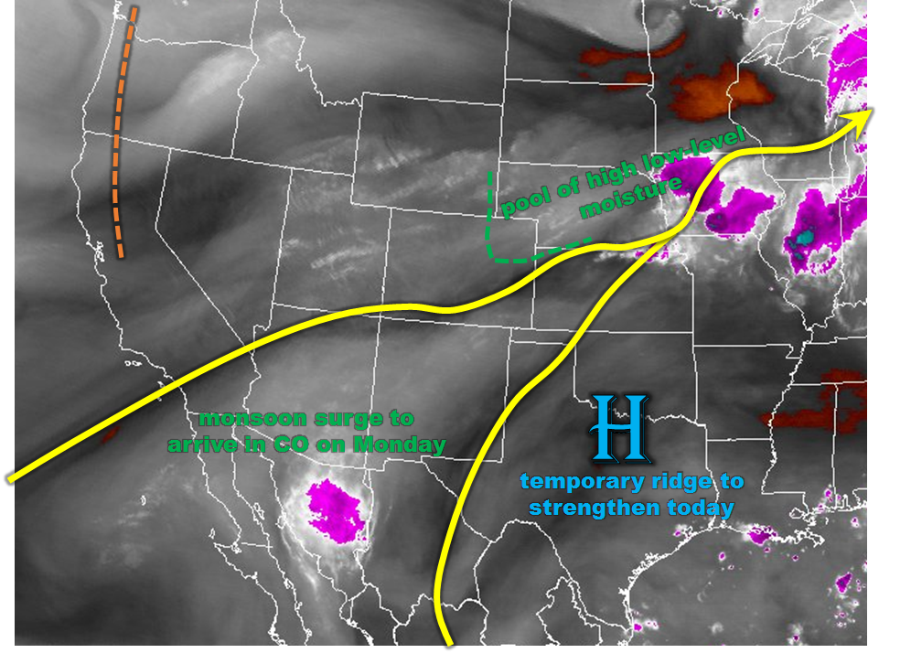
This morning’s water vapor image, shown below, shows a large-scale ridge will dominate Colorado’s weather today. The ridge is centered over Texas this morning, but will expand to affect a broad swath of real estate from Colorado all the way to the southeast Atlantic seaboard. The strengthening ridge will prevent large-scale rainfall for us, but that will not preclude scattered thunderstorm activity in favored regions. To determine those regions, we look at the morning’s moisture profile to find deeper moisture in the Northeast Plains extending southward along the Kansas border. Precipitable water values are as high as 1.2 inches in those regions and will stay that way through the day. Meanwhile, a residual surface circulation is noted across western KS. Although this circulation will dissipate through the day, it will focus a plume of higher moisture that will be directed towards northeast Colorado. Thus, as peak heating initiates the high-elevation trough, we expect isolated to widely scattered thunderstorms to be mostly limited to the Northeast Plains today. With high moisture in place, max 1-hour rain rates up to 2.0 inches will be possible. A Low flood threat is in place for parts of the area for isolated roadway and field flooding.
For areas farther west, the wildfire threat will continue today as afternoon relative humidity values will remain low. For today, wind speeds are expected to be weaker than yesterday, thus the overall threat will be lower but still exists.
Today’s Flood Threat Map
For more information on today’s flood threat, see the map below (hover over threat areas for more details). For Zone-Specific forecasts, scroll below the map.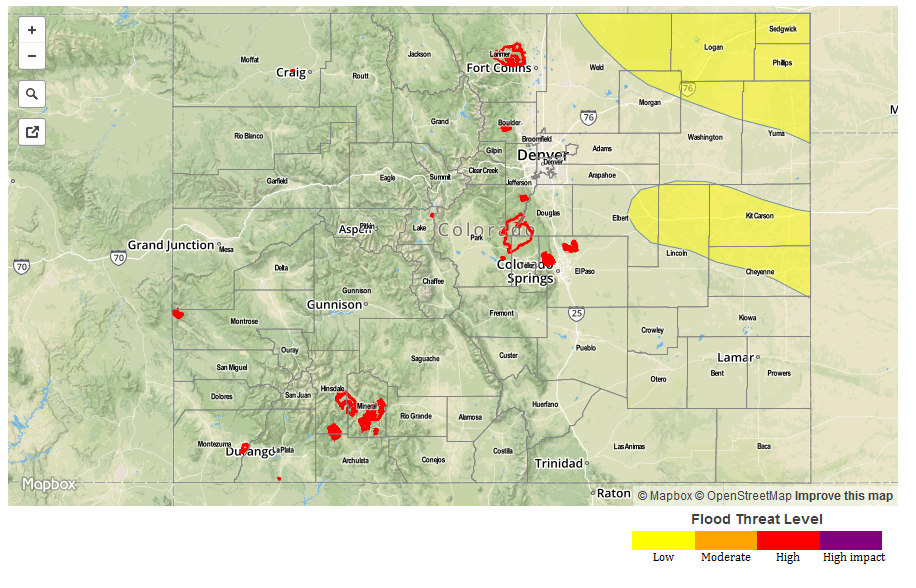
Zone-Specific Forecasts:
Southeast Plains, Northeast Plains, Palmer Ridge:
Sunny early then turning partly cloudy with isolated to scattered thunderstorms forming by early afternoon and lasting through the early evening. Highest coverage will be towards the Wyoming border. Max 1-hour rain rates up to 2.0 inches will be possible, leading to isolated roadway and field flooding. Hail up to 1.5 inches will be possible, along with wind speeds up to 60 mph. A Low flood threat has been posted for parts of the region.
Primetime: 2pm to 9pm
Southeast Mountains, Raton Ridge, Urban Corridor, Front Range:
Sunny early then turning partly cloudy and continued hot. An isolated thunderstorm will be possible across the northern and eastern areas from the early afternoon to the early evening. Max 1-hour rain rates up to 0.8 inch will be possible. Gusty winds up to 50 mph will accompany the strongest cells. Flooding is not expected today.
Primetime: 1pm to 7pm
San Juan Mountains, San Luis Valley, Northern Mountains, Grand Valley, Northwest Slope, Southwest Slope, Central Mountains:
Mostly sunny and continued hot. The main story continues to be the elevated wildfire threat across the region as low humidity values will combine with gusty winds for the afternoon hours. Wind speeds today will be weaker than yesterday, so the fire threat is lower. However, a Red Flag Warning remains in effect for many areas. Stay tuned to NWS forecasts for local details. Flooding is not expected today.