Issue Date: 7/23/2016
Issue Time: 10:20 AM
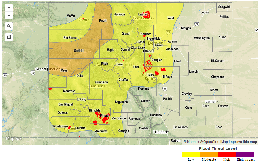
A LOW FLOOD THREAT IS FORECAST FOR PORTIONS OF THE URBAN CORRIDOR, NORTHEAST PLAINS, SOUTHEAST PLAINS, PALMER RIDGE, FRONT RANGE, SOUTHEAST MOUNTAINS, CENTRAL MOUNTAINS, NORTHERN MOUNTAINS, SAN JUAN MOUNTAINS, AND SOUTHWEST SLOPE.
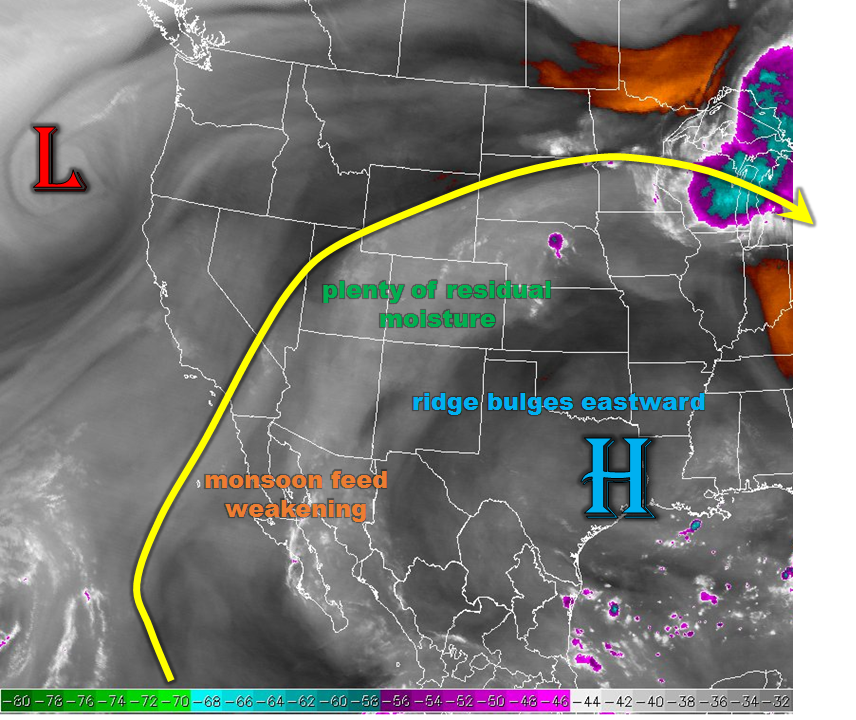
Current analysis shows the expansive upper-level high being flattened by an upper-level shortwave trough moving across the northern US. This has turned the flow aloft over Colorado to a more westerly direction, which will eventually result in drier air being ushered in from the west. At this time, though, that drier air sits across northern and western Utah, leaving IPW values elevated across Colorado. Eventually, the drier air will make its way into northwestern Colorado, likely this afternoon. The drier air will help reduce the coverage and intensity of any isolated-to-scattered storm activity over those areas.
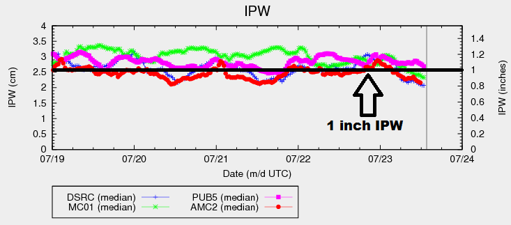
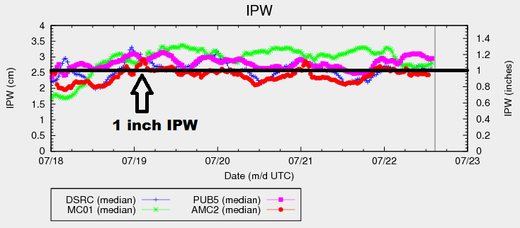
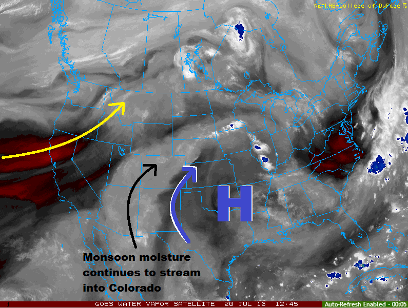
There will still be plenty of residual monsoonal moisture elsewhere, with the 4 normal reporting stations hovering between 0.75 inches and 1 inch. Moisture reinforcement will come to the eastern plains behind a surface cool front, as well. Generally speaking, there will be enough fuel for thunderstorms to produce localized heavy rainfall, so a low flood threat will be issued again this period. Overall, coverage and intensity will be less than previous days, except for over the plains where a few isolated strong-to-severe thunderstorms are expected. Please see the zone-specific forecast discussions below for more information about timing and rain rates.
Today’s Flood Threat Map
For more information on today’s flood threat, see the map below (hover over threat areas for more details). For Zone-Specific forecasts, jump below the map.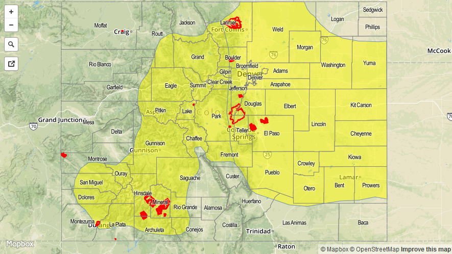

Zone-Specific Forecasts
Urban Corridor, Palmer Ridge, Raton Ridge, Northeast Plains, and Southeast Plains:
Isolated-to-scattered showers and thunderstorms are expected, with the main threats being gusty winds, locally heavy rainfall, and lightning. Storm coverage and intensity will be less than previous days, but a few will be strong enough to warrant flooding concerns, especially considering antecedent soil conditions. Otherwise, it will be a hot day, with temperatures climbing into the 90s and low 100s. Maximum rain rates are as follows:
Urban Corridor: 0.8-1.2 inches/hour
Palmer Ridge: 1.0-1.5 inches/hour
Northeast Plains and Southeast Plains: 1.0-2.0 inches/hour
Raton Ridge: 0.4-0.8 inches/hour
Timing: Noon – 11 PM, with a few showers/storms continuing over the plains into the early morning hours.
Front Range, Southeast Mountains, Northern Mountains, San Juan Mountains, Central Mountains, and Southwest Slope:
Isolated-to-scattered showers and thunderstorms are expected as residual moisture fuels another unsettled day across the High Country and Western Slope. The higher terrain will see the most activity, with storm motions carrying storms over lower valleys. Storms will move quicker than yesterday, which will act as a limit on the flood threat. Maximum rain rates are 0.6-1.2 inches/hour. Antecedent conditions from the past few days of rainfall are a concern, especially in steep terrain areas where enhanced runoff issues are greatest.
Timing: Noon – 10 PM
Northwest Slope and Grand Valley:
Mostly Sunny with only a couple isolated thunderstorms. Drier air will reach these regions first, likely by early this afternoon. This will reduce the rain rate potential, so no flood threat is warranted. Otherwise, temperatures will be warmer than normal.
Timing: 1 PM – 9 PM
San Luis Valley:
The main weather story today will be the sunny skies to start, turning to partly sunny as scattered showers/storms develop over the surrounding high terrain. A few showers/storms will move overhead, with maximum rain rates of 0.6-0.8 inches/hour.
Timing: Noon – 9 PM