Issue Date: 7/20/2016
Issue Time: 9:50 AM
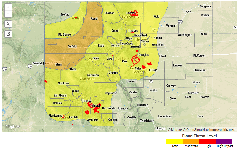
A MODERATE FLOOD THREAT IS ISSUED FOR PORTIONS OF THE NORTHERN MOUNTAINS, CENTRAL MOUNTAINS, GRAND VALLEY, AND NORTHWEST SLOPE.
A LOW FLOOD THREAT IS ISSUED FOR SURROUNDING AREAS, INCLUDING PORTIONS OF THE SOUTHWEST SLOPE, SAN JUAN MOUNTAINS, FRONT RANGE, URBAN CORRIDOR, PALMER RIDGE, AND NORTHEAST PLAINS.
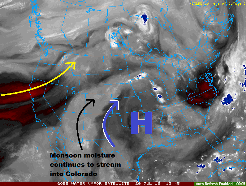
The continued stream of monsoonal moisture into the region is easy to pick out in the water vapor image below. With a strong high centered over the south-central US and an upper-level trough off the West Coast, west-southwest flow aloft continues over Colorado, pulling subtropical moisture into the state. Moisture values are comparable to yesterday’s values, albeit slightly less east of the mountains. The moisture content will set the stage for another unsettled day, widespread over the mountains, with more isolated-to-widely scattered coverage over adjacent lower elevations.
Showers and thunderstorms will get a slightly later start today, awaiting the influence of daytime heating and the arrival of the next disturbance out of western NM/eastern AZ. Initial development will begin over the High Country and Western Slope, moving off the mountains and over the Urban Corridor and adjacent plains during the early afternoon hours. Activity will continue into the late evening hours, diminishing across most locations by midnight. A lingering shower or two may continue over the higher terrain into the early morning hours. For more information regarding timing and rain rates, please see the zone-specific discussions below.
Today’s Flood Threat Map
For more information on today’s flood threat, see the map below (hover over threat areas for more details). For Zone-Specific forecasts, jump below the map.
 Zone-Specific Forecasts
Urban Corridor, Northeast Plains, and Palmer Ridge:
Isolated-to-scattered showers/thunderstorms are expected during the afternoon and evening, coming to an end between 10 PM and midnight. Slow-moving storms and locally heavy rainfall are a concern, thus the low flood threat. Other threats from storms include gusty winds and dangerous lightning. Maximum rain rates 0.8-1.4 inches/hour.
Timing: 1 PM – Midnight
Southeast Plains and Raton Ridge:
Isolated-to-widely scattered showers/storms are expected, beginning during the early afternoon and continuing into the evening hours. The best coverage will occur along and near the higher terrain of the Southeast Mountains, with more isolated coverage to the east. Maximum rain rates are 0.6-1.2 inches/hour. Strong winds and lightning are the other threats.
Baca, Prowers, and eastern portions of Bent, Las Animas, Kiowa, and Cheyenne Counties will stay mainly dry.
Timing: Noon – 11 PM
Northwest Slope, Northern Mountains, Central Mountains, and Grand Valley:
Scattered-to-widespread showers and thunderstorms are expected, capable of producing heavy rainfall. IPW values are highest across western Colorado, and moisture transport will shift the axis of deepest moisture across the moderate flood threat area. Repeated rounds of showers/storms, as well as slow-moving storms, are the main concern. Maximum rain rates are 1.0-1.6 inches/hour. Gusty winds and dangerous lightning will attend thunderstorms.
Timing: 11 AM – Midnight
Front Range, Southeast Mountains, San Luis Valley, San Juan Mountains, and Southwest Slope:
Scattered-to-widespread showers and thunderstorms are expected over the higher terrain, with more isolated-to-scattered coverage for lower valleys. Slow-moving storms are a concern when coupled with locally heavy rainfall. Gusty winds and lightning will also attend thunderstorms. Maximum rain rates are 0.8-1.4 inches/hour.
Timing: 11 AM – 2 AM