Issue Date: 7/22/2016
Issue Time: 10:20 AM
A LOW FLOOD THREAT IS ISSUED FOR PORTIONS OF THE SOUTHWEST SLOPE, GRAND VALLEY, SAN JUAN MOUNTAINS, CENTRAL MOUNTAINS, NORTHWEST SLOPE, NORTHERN MOUNTAINS, FRONT RANGE, URBAN CORRIDOR, PALMER RIDGE, SOUTHEAST PLAINS, AND NORTHEAST PLAINS.
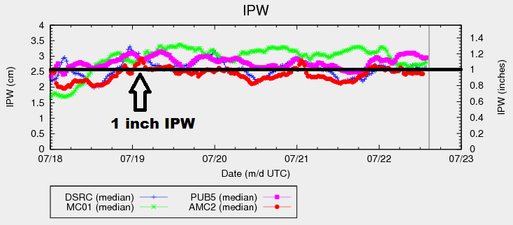
Two main features in the larger scale atmospheric pattern will bring about another day of monsoon-driven showers and thunderstorms. The strong upper-high centered over the central US will shift westward today, while an upper-level shortwave trough will move onshore the Pacific Northwest and track to the east across the Northern US. These two features will funnel monsoonal moisture across Colorado through today/tonight, fueling another period of unsettled weather. The spark will be provided by a weak disturbance rotating across the state from the southwest. Overall, a general lack of wind shear and instability will keep most storms garden variety, with the main threats being locally heavy rainfall and gusty winds (up to 40-50 mph). IPW values continue to hover around/above the 1 inch mark, so activity will produce rainfall efficiently.
The strongest storms, relatively speaking, will occur across the Northeast Plains, Palmer Ridge, and northeastern portions of the Southeast Plains. In that area, instability and shear will be sufficient for a couple strong-to-marginally severe thunderstorms. The main threats from these storms will be strong winds, hail up to 1.5 inches in diameter, and locally heavy rainfall. For more information, please see the zone-specific forecast discussions below.
Today’s Flood Threat Map
For more information on today’s flood threat, see the map below (hover over threat areas for more details). For Zone-Specific forecasts, jump below the map.

Zone-Specific Forecasts
Urban Corridor, Northeast Plains, and Palmer Ridge:
Isolated-to-scattered showers and thunderstorms are expected this afternoon and evening, with a few continuing into the overnight hours over the plains. The main threats from any storm activity will be locally heavy rainfall and gusty outflow winds. A couple isolated strong-to-marginally severe storms are possible, mainly over the Northeast Plains and Palmer Ridge. The main threats would these storms will be heavy rainfall, hail up to 1.5 inches in diameter, and strong winds (50-60 mph). Maximum rain rates are as follows:
Urban Corridor: 0.8-1.4 inches/hour
Palmer Ridge: 1.2-1.6 inches/hour
Northeast Plains: 1.5-2.0 inches/hour
Timing: 1 PM – Midnight
Southeast Plains and Raton Ridge:
Isolated-to-widely scattered showers/thunderstorms are expected. Coverage will be best near the higher terrain of the Southeast Mountains, and near the preferred terrain of the Palmer Ridge. One or two isolated storms will become strong over far northeastern portions of the Southeast Plains, with small hail, strong winds, and locally heavy rainfall being the main threats. Maximum rain rates are as follows:
Southeast Plains: 1.2-1.6 inches/hour
Raton Ridge: 0.4-0.6 inches/hour
Timing: 1 PM – 1 AM
Northwest Slope, Northern Mountains, Central Mountains, Grand Valley, Front Range, Southeast Mountains, San Luis Valley, San Juan Mountains, and Southwest Slope:
Another period of unsettled weather on tap with scattered showers/thunderstorms expected. Activity will begin to develop around 11 AM – Noon, increasing in coverage through the afternoon and early evening, and then diminish after sunset. Locally heavy rainfall is likely underneath thunderstorms, and slow-moving storms are a concern. Antecedent conditions also deserve attention, as runoff will be enhanced and unstable soils may result in mud/debris flows/rock slides. Maximum rain rates for the Front Range, Northern Mountains, and Central Mountains will be 0.8-1.2 inches/hour, with 0.6-1.0 inches/hour for all other regions.