Issue Date: Thursday, July 21st, 2016
Issue Time: 10:42AM MDT
— LOW flood threat for parts of Central Mountains, Northern Mountains, Grand Valley, San Juans and Southwest Slope
— LOW flood threat for parts of Front Range and Palmer Ridge
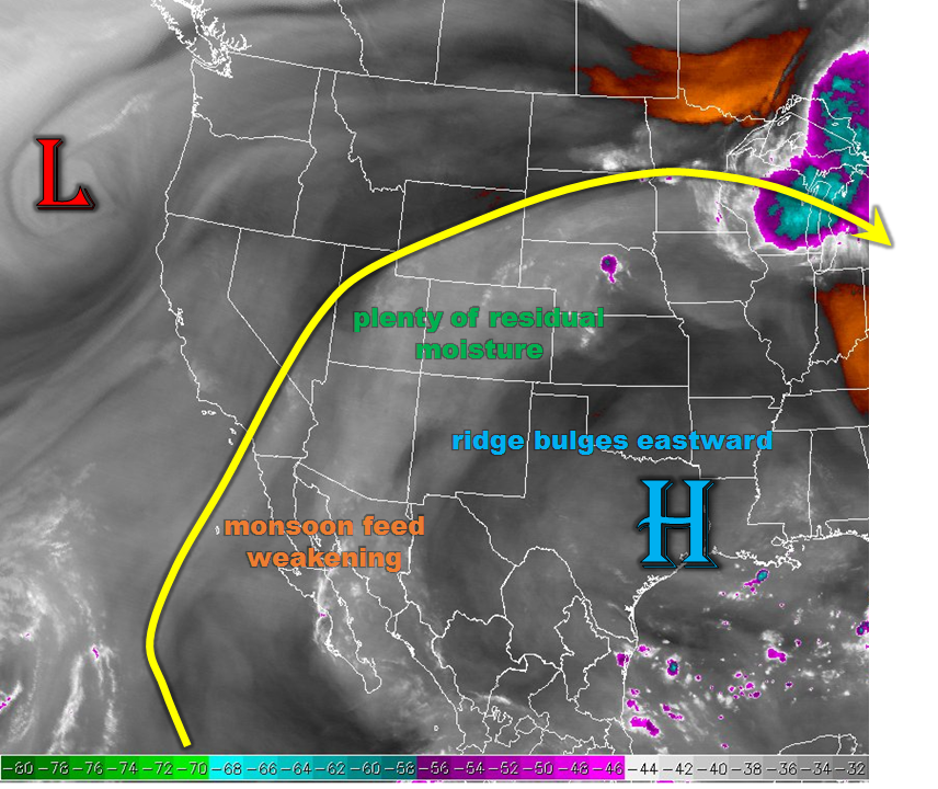
This morning’s water vapor image, below, appears quite similar to yesterday’s. At face value. However, important details emerge upon closer inspection. The most notable difference in the past 24-hours is the ridge centered southeast of Colorado will bulge out noticeably to the west. The main implication of this is essentially turning off the monsoon spigot. That said, plenty of residual moisture remains this morning so heavy rainfall storms will be had once again. However, parts of the far southwest will see some notable upper-level drying. Thus, the main region for heavy rainfall storms will shift northward today and roughly straddle the I-70 corridor of the western slope. The second important difference today is that the steering flow will all but cease to exist as the ridge axis moves almost directly overhead. Regarding heavy rainfall, this has a pro and con component. On the one hand, a lack of storm motion will allow for very heavy short-term rainfall at a given location. On the other hand, lack of shear means that downdrafts and updrafts will have a hard time separating. The ultimate effect of this is that today we are looking for sub-hourly heavy rainfall that could lead to isolated flood problems. Lastly, antecedent rainfall amounts of 2-3 inches in the past 72 hours suggest runoff will be more effective today. In all, a Low flood threat captures these factors.
A severe storm cannot be ruled out across the far eastern parts of the state in the early to late evening. However, odds are slim and hail up to 1 inch and wind up to 55mph should be the bigger threat compared to heavy rainfall. Given the very low odds, a flood threat is not warranted in this region today.
 Today’s Flood Threat Map
For more information on today’s flood threat, see the map below (hover over threat areas for more details). For Zone-Specific forecasts, scroll below the map.

Zone-Specific Forecasts:
San Juan Mountains, Northern Mountains, Grand Valley, Northwest Slope, Southwest Slope, Central Mountains:
Partly to mostly cloudy early with scattered showers and storms increasing in coverage and intensity. Highest coverage will be in central areas, especially the Sawatch and Gore ranges. Max 15-min rain rates up to 0.5 inches, 1-hr rain rates up to 1.2 inches, and 3-hr rain rates up to 2.1 inches are possible. Isolated flash flooding is possible, along with debris slides and mud flows. Antecedent conditions have been wet, so locations that have experienced rainfall since Monday are most vulnerable for flooding. A Low flood threat has been posted. Storms will quickly subside as sunset approaches.
Primetime: 11AM to 8:30PM
Front Range, Urban Corridor, Northeast Plains, Palmer Ridge:
Mostly sunny early then isolated to scattered storms forming by early afternoon, first over the higher terrain. Highest coverage will be over the Palmer Ridge. Max 30-min rain rates up to 0.8 inches possible. A Low flood threat has been posted for parts of the region for flash flooding, road and field flooding as well as debris slides and mud flows in the higher terrain. An isolated severe storm is possible in far eastern areas, with large hail and wind being the main threat. It will be hot again today for areas without storms.
Primetime: 1PM to 9PM (except 11PM for severe weather farther east)
Southeast Mountains, Raton Ridge, Southeast Plains, San Luis Valley:
Sunny early then turning partly cloudy. Isolated storms are possible mainly over the higher terrain. Max 30-min rain rates up to 0.6 inches are possible. Flooding is not expected today. It will be very hot today with highs topping 100F for many low elevation locations.
Primetime: 12PM to 6PM