Issue Date: 8/4/2016
Issue Time: 10:05 AM
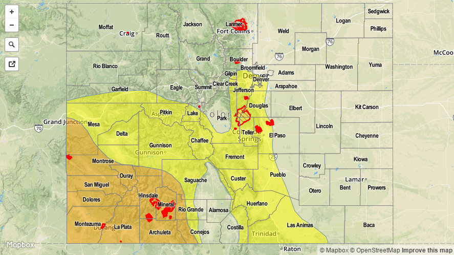
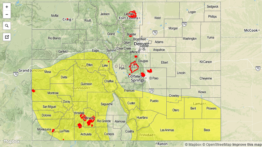
A MODERATE FLOOD THREAT IS FORECAST TODAY FOR PORTIONS OF THE SAN JUAN MOUNTAINS, SOUTHWEST SLOPE, CENTRAL MOUNTAINS, AND SOUTHEAST MOUNTAINS.
A LOW FLOOD THREAT IS ISSUED FOR SURROUNDING AREAS, AS WELL AS PORTIONS OF THE RATON RIDGE, SOUTHEAST PLAINS, NORTHERN MOUNTAINS, NORTHWEST SLOPE, GRAND VALLEY, AND SAN LUIS VALLEY.
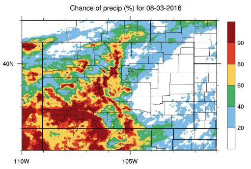
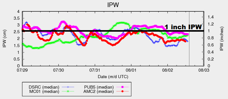
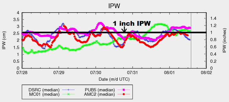
The monsoonal surge continues from the south-southwest, as moisture values remain anomalously high across western and southern Colorado. If you take a look at the water vapor imagery below, you’ll notice that both Pueblo (pink line) and Grand Junction (green line) are above 1 inch; Grand Junction is reaching towards 1.4 inches, heightening the concern for flash flooding/flooding issues.
Embedded in this flow of moisture is a disturbance at 700 mb, which will work its way east-northeast across Colorado throughout today and tonight. This wave will support scattered-to-widespread showers and thunderstorms across the High Country and Western Slope, with the best coverage generally to the south of I-70. Locally heavy rainfall is a concern, especially in the areas denoted by the moderate flood threat. Particular concern exists for burn scars (including recent burns like Hayden Pass) and steep terrain with saturated soils from previous days’ rainfall (high terrain of the Southwest Slope and San Juan Mountains).
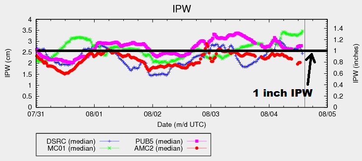
Boulder’s IPW values (blue line) has taken a sharp decrease in the last hour or so, thanks to the passing of a cool front through eastern Colorado. Behind this front, drier, low-level air is filling in across the lower elevations. This will lead to a dry day through the afternoon and into the early evening across the Northeast Plains, with only an isolated shower/weak thunderstorm possible over the Urban Corridor and Palmer Ridge. This will change later this evening/tonight as the 700 mb disturbance shifts across the area, bringing showers/thunderstorms to the area through the overnight hours and into tomorrow morning.
Further to the south, the cool front is nearing the Raton Ridge at this time. Behind it exists the same drier air and cool temperatures in the low-levels, which will stifle showers/thunderstorms behind the front through the afternoon hours. Along the front, i.e., across the Raton Ridge and southern portions of the Southeast Plains, scattered showers/thunderstorms will develop this afternoon. A couple of these storms will become severe, producing hail, strong winds, and heavy rainfall. The low flood threat takes this scenario into account. Just as areas to the north, more numerous thunderstorms will move across the Southeast Plains and Raton Ridge tonight and into tomorrow morning in association with the passing disturbance.
Today’s Flood Threat Map
For more information on today’s flood threat, see the map below (hover over threat areas for more details). For Zone-Specific forecasts, jump below the map.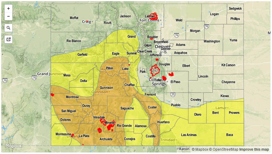

Zone-Specific Forecasts
Urban Corridor, Northeast Plains and Palmer Ridge:
Mainly dry and cool through the afternoon hours, with only an isolated shower/weak thunderstorm or two expected. The disturbance will move overhead during the late evening/overnight/morning hours, bringing numerous showers and a few thunderstorms to the area. Efficient rainfall processes will lead to locally heavy rainfall, but not enough to warrant the issuance of a flood threat. Instead, we will mention to be alert to the possibility of street/field ponding underneath thunderstorms in poor drainage areas. Maximum rain rates will be 0.4-0.8 inches/hour.
Southeast Plains and Raton Ridge:
Scattered showers/thunderstorms are expected along the cool front this afternoon and evening, mainly south of Highway 50. A few of these storms will become strong-to-severe, producing hail (up to 1.5 inches in diameter), strong winds (gusts up to 65 mph), and heavy rainfall. During the late evening hours, shower/storm coverage will increase in response to the disturbance moving through the area. This activity will continue into tomorrow morning. Maximum rain rates will be 2.0-3.0 inches/hour for the plains, and 1.0-2.0 inches/hour for the Raton Ridge.
Timing: 11 AM – 11 AM
Front Range, Northern Mountains, Southeast Mountains, Northwest Slope, San Juan Mountains, Southwest Slope, San Luis Valley, Central Mountains, and Grand Valley:
Scattered-to-widespread showers and thunderstorms are expected throughout the period, with the best coverage occurring across the higher terrain of the Continental Divide, San Juan Mountains, Southwest Slope, and Southeast Mountains. The Front Range will get a late start to the better activity, relying heavily on the passing disturbance to kick off activity. The Northwest Slope will be the furthest from the upper-level support, so only isolated showers/weak thunderstorms are expected there. Locally heavy rainfall is a concern, especially with slow storm motions expected. Maximum rain rates are as follows:
Front Range and Northwest Slope: 0.3-0.6 inches/hour
Northern Mountains: 0.4-0.8 inches/hour
Central Mountains, Southwest Slope, San Juan Mountains, Southeast Mountains, Grand Valley, and San Luis Valley: 0.8-1.3 inches/hour
Timing: 11 AM – 11 AM