Issue Date: 8/2/2016
Issue Time: 9:40 AM
A LOW FLOOD THREAT IS FORECAST TODAY FOR PORTIONS OF THE FRONT RANGE, SOUTHEAST MOUNTAINS, URBAN CORRIDOR, PALMER RIDGE, SOUTHEAST PLAINS, AND RATON RIDGE.
A LOW FLOOD THREAT IS FORECAST FOR PORTIONS OF THE SOUTHWEST SLOPE, SAN JUAN MOUNTAINS, GRAND VALLEY, AND CENTRAL MOUNTAINS.
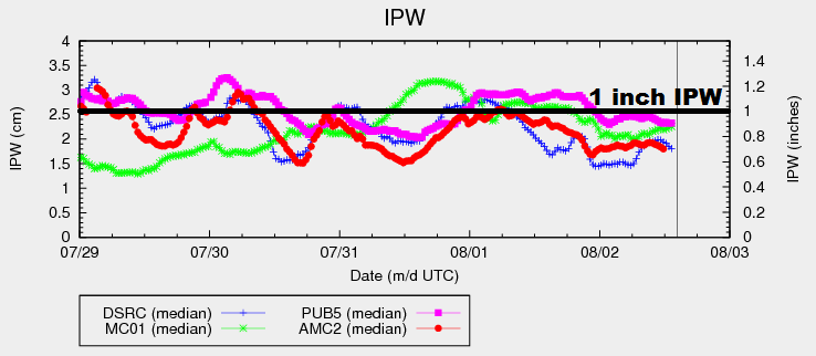
Moisture content (IPW) as measured by the four normal reporting stations is fairly close to average for this time of year. In fact, this morning’s soundings from Grand Junction and Boulder show precipitable water values within 0.02 inches of average for the date. It is expected that moisture will bump upward somewhat during the day, mainly across southern Colorado where monsoonal moisture continues to nudge northward. East of the mountains, IPW values will increase slightly due to a surface moisture surge from the east this afternoon/evening. All told, these “bumps” in this morning’s moisture will push IPW values back to near yesterday afternoon’s levels.
A weak disturbance will move across the state this afternoon and evening, coinciding with peak heating and moisture values, increasing coverage of showers/thunderstorms. Storms associated with this disturbance will first form over the High Country and Western Slope, generally move eastward, with a few pushing over the lower elevations of eastern Colorado during the late afternoon/early evening hours. Slow-moving storms due to light winds aloft are the main concern behind the low flood threat, as efficient rainfall over one area for extended period of time can cause issues, especially for steeper terrain and urban areas.
During the later evening hours and just after dark (7 PM – 11 PM), there is a slight chance (20%) of new thunderstorm development over the Front Range/Urban Corridor owing to continued upslope flow. The areas that will most likely be affected by any of this development will be eastern Larimer, western Weld, Boulder, eastern Gilpin, Broomfield, Denver, western Adams, western Arapahoe, and northern/eastern Jefferson counties. This is accounted for in the low flood threat area outlined in the map below.
Today’s Flood Threat Map
For more information on today’s flood threat, see the map below (hover over threat areas for more details). For Zone-Specific forecasts, jump below the map.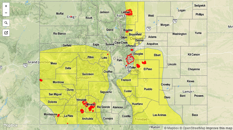

Zone-Specific Forecasts
Front Range, Southeast Mountains, Urban Corridor, Northeast Plains, Palmer Ridge, Raton Ridge, and Southeast Plains:
Isolated-to-scattered showers/thunderstorms expected, with the best coverage expected over the mountains and Raton Ridge. Much of the plains will remain weakly capped by warm air in the mid-levels, but a few storms are still expected in associated with the disturbance aloft. As mentioned above, redevelopment along the Front Range/Urban Corridor between 7 PM and 11 PM is possible (20% chance). Maximum rain rates are as follows:
Front Range, Urban Corridor, Palmer Ridge, and Southeast Mountains: 0.8-1.2 inches/hour
Northeast Plains: 1.0-1.5 inches/hour
Southeast Plains: 1.5-2.2 inches/hour
Raton Ridge: 0.9-1.3 inches/hour
Timing: 11 AM – 11 PM over the mountains, 1 PM – Midnight over the plains and ridges
San Juan Mountains, Southwest Slope, San Luis Valley, Northwest Slope, Northern Mountains, Central Mountains, and Grand Valley:
Isolated to the north, scattered to the south, showers/thunderstorms are expected today. Most will be garden variety, producing mainly gusty winds and light rainfall. A few will be stronger, however, and will likely produce locally heavy rainfall. The higher terrain of the San Juan Mountains, Southwest Slope, Grand Valley, and Central Mountains have the highest relative chance of experiencing heavy rain; these areas are outlined in the low flood threat area. Maximum rain rates will be:
Northwest Slope and Northern Mountains: 0.15-0.3 inches/hour
San Luis Valley: 0.4-0.8 inches/hour
Central Mountains, Grand Valley, San Juan Mountains, and Southwest Slope: 0.8-1.2 inches/hour
Timing: 11 AM – 9 PM, with a few isolated showers/weak thunderstorms lingering into the early morning hours over higher terrain in southern zones