Issue Date: 8/1/2016
Issue Time: 10:17 AM
A LOW FLOOD THREAT IS FORECAST FOR PORTIONS OF THE GRAND VALLEY, CENTRAL MOUNTAINS, SOUTHWEST SLOPE, SAN JUAN MOUNTAINS, SOUTHEAST MOUNTAINS, RATON RIDGE, AND SOUTHEAST PLAINS.
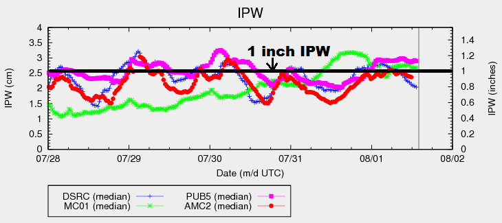
Drier air is poised to move into the northern third of Colorado behind the shortwave trough that passed through Colorado last night. The drying is showing up in the morning’s IPW trace (chart below) with Boulder falling below 0.8 inches. A bit of mid-level warming will accompany the drying as the ridging builds slightly over the area, weakly capping the environment. A few isolated showers/weak thunderstorms will still develop, mainly over the mountains, owing to the influence of orographic effects. Most of the Northeast Plains will remain capped and dry, especially areas north and east of a line from Alvin to Fort Morgan to Hereford, which is a nice change from recent days of scattered rainfall.
Further to the south, there will be plenty of moisture available to showers/thunderstorms, resulting in efficient rainfall from any activity. Over the mountains, isolated-to-scattered showers/thunderstorms are expected, with the best coverage expected over the higher terrain of the Southwest Slope, San Juan Mountains, and Central Mountains. Instability/shear values will be sufficient enough to produce a couple of stronger storms capable of locally heavy rainfall; thus, the issuance of the low flood threat.
To the east, the Southeast Mountains and Raton Ridge will be dotted with scattered thunderstorms capable of heavy rainfall. The IPW value (~1.2 inches) measured at Pueblo is the highest of the four normal reporting stations (see chart above). A weak disturbance will work across the area and then over the Southeast Plains this afternoon/evening, which will trigger isolated-to-scattered showers/storms over the plains. A couple storms will be strong/marginally severe, with the main threats being hail, strong winds, and periods of heavy rainfall. For more information regarding rain rates and timing, please see the zone-specific forecast discussions below.
Today’s Flood Threat Map
For more information on today’s flood threat, see the map below (hover over threat areas for more details). For Zone-Specific forecasts, jump below the map.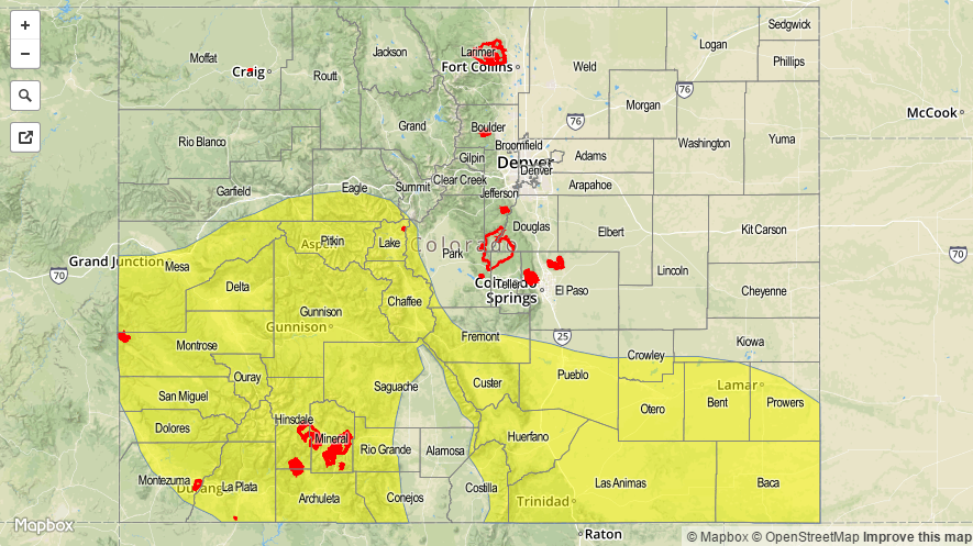

Zone-Specific Forecasts
Urban Corridor and Northeast Plains:
The environment will be weakly capped today, resulting in a dry day for a majority of the area. Locations near the mountains and Palmer Ridge will see the most coverage, relatively speaking, with isolated showers/thunderstorms. Maximum rain rates will be 0.2-0.4 inches/hour.
Timing: Noon – 11 PM
Southeast Mountains, Raton Ridge, Palmer Ridge, and Southeast Plains:
Scattered showers/thunderstorms expected over and near the mountains, with more isolated-to-widely scattered coverage elsewhere. Locally heavy rainfall will attend the strongest storms, thus the issuance of the low flood threat. Maximum rain rates are as follows:
Southeast Mountains: 1.0-1.4 inches/hour
Raton Ridge: 1.2-1.6 inches/hour
Southeast Plains: 1.5-2.2 inches/hour
Palmer Ridge: 0.6-0.9 inches/hour
Timing: 11 AM – 1 AM
Northern Mountains and Northwest Slope:
Much of the area will remain dry today, with only isolated showers/weak storms over the higher terrain. Drier air will keep rain rates down, resulting in gusty winds and lightning as the main threats. Maximum rain rates will be less than 0.25 inches/hour.
Timing: Noon – 9 PM
Front Range, Central Mountains, San Juan Mountains, Southwest Slope, Grand Valley, and San Luis Valley:
Isolated-to-scattered showers/thunderstorms expected, with the best coverage expected over the Central Mountains, San Juan Mountains, and Southwest Slope. Locally heavy rainfall is a concern with IPW values near, or just above, 1 inch. Maximum rain rates will be 1.0-1.4 inches/hour, with areas near the CO/NM border having the highest relative probability to achieve these rates.
Timing: 11 AM – 11 PM, with a few showers/storms continuing into the morning hours tomorrow, mainly over the higher terrain