Issue Date: 8/3/2016
Issue Time: 9:58 AM
A MODERATE FLOOD THREAT IS FORECAST TODAY FOR PORTIONS OF THE SAN JUAN MOUNTAINS, SOUTHWEST SLOPE, AND GRAND VALLEY.
A LOW FLOOD THREAT IS FORECAST TODAY FOR SURROUNDING AREAS AND PORTIONS OF THE CENTRAL MOUNTAINS, FRONT RANGE, URBAN CORRIDOR, SOUTHEAST MOUNTAINS, AND RATON RIDGE.
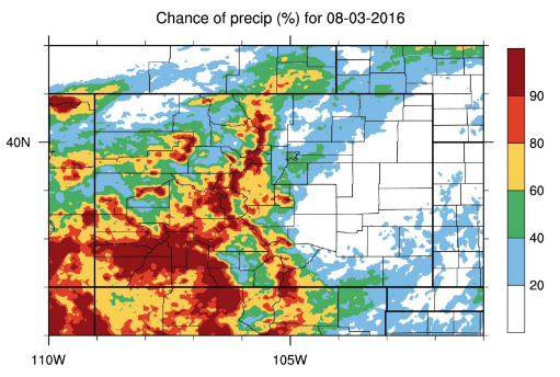
Instead of using the usual IPW chart or water vapor image, I have decided that today is a good time to show the “Chance of Precipitation” plot from our internal toolbox. As you can see below, it highlights western Colorado well, especially the higher terrain areas. This is due to the incoming surge of monsoonal moisture into the area, with IPW values pushing 1.0-1.3 inches this morning across southwestern Colorado. This influx of moisture will continue through the period, providing the fuel for efficient rainfall from all showers/thunderstorms.
Additionally, a weak 700 mb disturbance is noted in this morning’s observations, and is expected to move into the four corners region. This will provide support for more numerous storms and enhanced precipitation across southwestern Colorado. Steep terrain and burn scars are areas of highest relative concern as storm motions are expected to be slow, which could result in not only flooding issues, but also rock/mud slides, debris flows, etc. For areas further north, some drying has occurred over the last 12 hours or so, and this will limit rainfall rates in those areas.
For locations east of the mountains, weak westerly flow aloft will allow a few storms to move off of the higher terrain and over adjacent lower elevations. However, slight warming aloft will keep the environment capped over most of the area, and limit the instability available to any storms that do form/move overhead. The best opportunity for heavy rainfall will be across far western portions of the Southeast Plains and over the Raton Ridge, where orographic effects, better moisture, and proximity to the weak 700 mb disturbance will aid thunderstorm development/maintenance. Towards the morning hours, a cool front will begin to pass through the area from north to south, which will set the stage for tomorrow’s forecast.
Today’s Flood Threat Map
For more information on today’s flood threat, see the map below (hover over threat areas for more details). For Zone-Specific forecasts, jump below the map.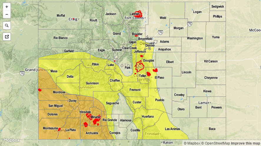

Zone-Specific Forecasts
Urban Corridor, Northeast Plains, Palmer Ridge, Southeast Plains, and Raton Ridge:
Isolated-to-scattered showers/thunderstorms expected along and near the higher terrain and along the Raton Ridge. Most storms will be garden variety, but the amount of moisture combined with slow-moving storms means locally heavy rainfall is a concern for areas highlighted in the low threat area. Maximum rain rates are as follows:
Urban Corridor: 0.8-1.2 inches/hour
Palmer Ridge and Northeast Plains: 0.4-0.8 inches/hour
Southeast Plains: 1.2-2.0 inches/hour
Raton Ridge: 1.2-1.6 inches/hour
Timing: 11 AM – 10 PM for the Raton Ridge and Southeast Plains, 1 PM – Midnight for the Urban Corridor and Palmer Ridge, and 3 PM – 1 AM for the Northeast Plains.
Front Range and Southeast Mountains:
Isolated-to-scattered showers/thunderstorms expected. Locally heavy rainfall is a concern over the Southeast Mountains and the southern Front Range. The maximum rain rate for the Front Range is 0.8-1.2 inches/hour and 1.0-1.5 inches/hour for the Southeast Mountains.
Timing: 11 AM – Midnight for the Front Range and 10 AM – Midnight for the Southeast Mountains. A few lingering showers will continue into the early morning.
San Juan Mountains, Southwest Slope, San Luis Valley, Central Mountains, and Grand Valley:
Scattered-to-widespread showers and thunderstorms are expected, with the best coverage occurring across the Southwest Slope and San Juan Mountains. Deep moisture, slow-moving storms, and locally heavy rainfall are a concern for flash flooding issues, as well as rock/mud slides, debris flows, etc. Maximum rain rates are:
Southwest Slope and San Juan Mountains: 1.0-2.0 inches/hour
Grand Valley: 1.0-1.5 inches/hour
Central Mountains and San Luis Valley: 0.8-1.2 inches/hour
Timing: 10 AM – Midnight, with isolated-to-scattered showers/storms continuing into the morning hours, especially across the higher terrain of southwest Colorado.
Northwest Slope and Northern Mountains:
Isolated-to-scattered showers and storms. A bit of drying has taken place overnight and this morning, and this will help limit rain rates over these regions. Maximum rain rates will be 0.4-0.8 inches/hour, which is below flood threat thresholds.
Timing: 11 AM – 11 PM