Issue Date: 8/12/2016
Issue Time: 9:48 AM
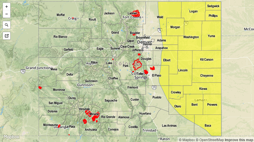
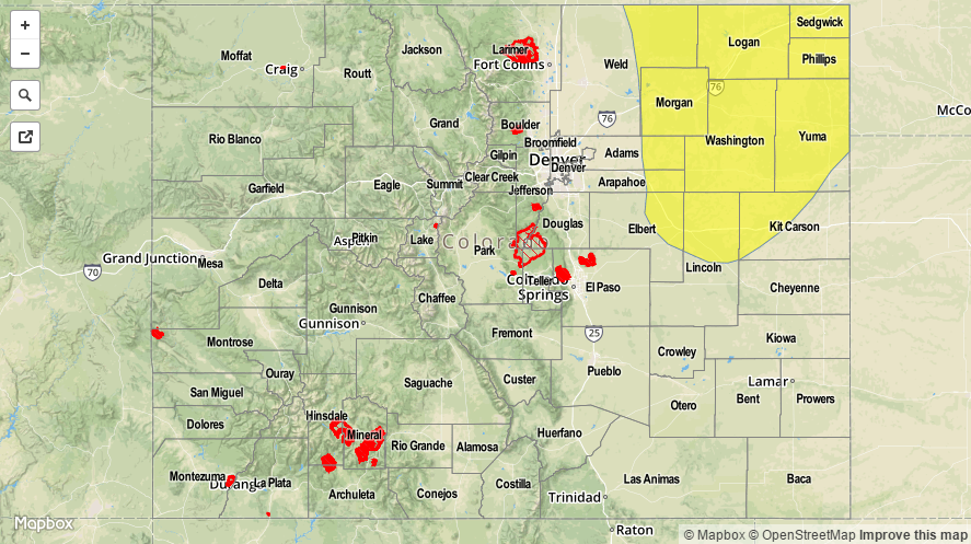
A LOW FLOOD THREAT HAS BEEN ISSUED FOR PORTIONS OF THE URBAN CORRIDOR, PALMER RIDGE, SOUTHEAST PLAINS, RATON RIDGE, SOUTHEAST MOUNTAINS, AND FRONT RANGE.
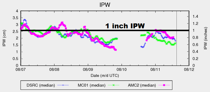
The Continental Divide defines a clear line in the sand for today’s forecast, so to speak. For areas west of the Divide, mostly sunny skies and dry conditions will rule the forecast, with only an isolated brief shower or two possible over the higher terrain near the Continental Divide. Moisture, as evident in the IPW graph below, is lower over western Colorado, with Grand Junction measuring about 0.4 inches IPW this morning. Afternoon high temperatures will be a few degrees cooler than yesterday behind the weak cool front that passed through overnight.
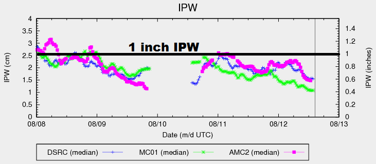
Along the Divide and to the east, slightly better moisture is in place, albeit not a significant amount. IPW values in the graph below show Schriever AFB and Boulder at approximately 0.6 inches, well below the 1 inch threshold that we often discuss. With some lingering moisture (mainly in the low-levels), northwest flow aloft, and light easterly surface flow, the potential exists for a few strong/severe storms to develop along the I-25 corridor south of Douglas County, including the eastern slopes of the mountains and extending east over the Palmer Ridge and south across the Southeast Plains. Any strong/severe storms in this area will have the potential to produce locally heavy rainfall; thus, the issuance of the low flood threat. For the rest of the area, isolated-to-widely scattered showers/thunderstorms will be possible, but a more subsident airmass overhead will limit their intensity and coverage. For more details on timing and rain rates, please see the zone-specific forecast discussions below.
Today’s Flood Threat Map
For more information on today’s flood threat, see the map below (hover over threat areas for more details). For Zone-Specific forecasts, jump below the map.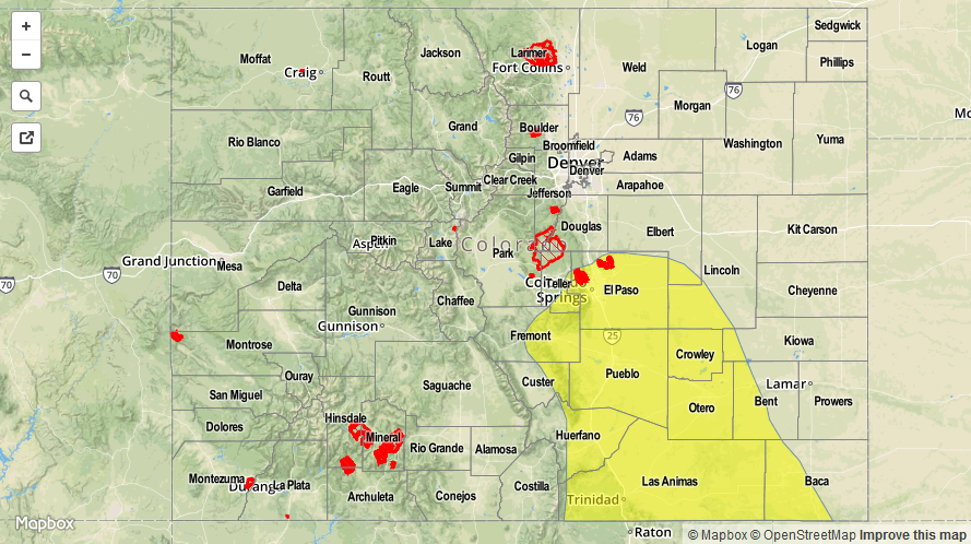

Zone-Specific Forecasts
Urban Corridor, Northeast Plains, Palmer Ridge, Southeast Plains and Raton Ridge:
Isolated-to-scattered showers/storms expected. A few will be strong/severe, mainly across the low flood threat area. Most showers and storms will be garden variety, producing gusty winds, lightning, and light-to-moderate rainfall. Over the low flood threat area, better moisture pooling has taken place and stronger storms will be capable of producing locally heavy rainfall. Maximum rain rates are as follows:
Urban Corridor: 0.6-1.0 inches/hour
Palmer Ridge: 0.9-1.4 inches/hour
Northeast Plains: 0.4-0.8 inches/hour
Southeast Plains and Raton Ridge: 1.2-2.0 inches/hour
Timing: 1 PM – Midnight, with a few showers/storms ongoing across the Southeast Plains and Raton Ridge into the morning hours
Front Range and Southeast Mountains:
Isolated-to-scattered showers/storms expected. The best coverage will occur south of I-70. With lesser moisture than lower elevations, most storms will be garden variety, producing more gusty winds and lightning than rain. Still, brief periods of moderate-to-heavy rainfall will be possible for eastern slopes, mainly south of Highway 24. Maximum rain rates will be 0.6-1.0 inches/hour.
Timing: 1 PM – Midnight
Northern Mountains, Northwest Slope, San Juan Mountains, Southwest Slope, San Luis Valley, Central Mountains, and Grand Valley:
A couple isolated showers/weak storms are expected across the higher terrain near the Continental Divide. Otherwise, today will be mostly sunny and dry, with high temperatures a few degrees cooler than yesterday. Maximum rain rates from any activity will be less than 0.2 inches/hour.
Timing: Noon – 8 PM