Issue Date: 8/9/2016
Issue Time: 9:28 AM
A LOW FLOOD THREAT IS FORECAST TODAY FOR PORTIONS OF THE NORTHEAST PLAINS AND PALMER RIDGE.
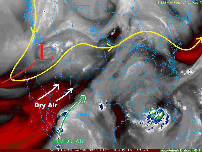
Shower/thunderstorm activity will take a downswing today as drier air invades from the west/southwest. As shown in the water vapor image below, the low pressure trough digging along the west coast is acting to pull drier air (red colors) into the region. The moist plume across New Mexico and western Texas has been shunted to the south and east by this dry air, and IPW values have fallen in concert. With all of that said, there will be enough residual moisture to fuel isolated-to-widely scattered showers/thunderstorms; first developing over the higher terrain, and then moving northeastward over the lower elevations. Outflow boundaries from the mountain convection, as well as surface dewpoints in the 40s and 50s, will provide enough moisture for periods of heavy rain from any stronger thunderstorms that develop. The low flood threat area takes this into account. For more information on timing and rain rates, please see the zone-specific forecast discussions below.
Today’s Flood Threat Map
For more information on today’s flood threat, see the map below (hover over threat areas for more details). For Zone-Specific forecasts, jump below the map.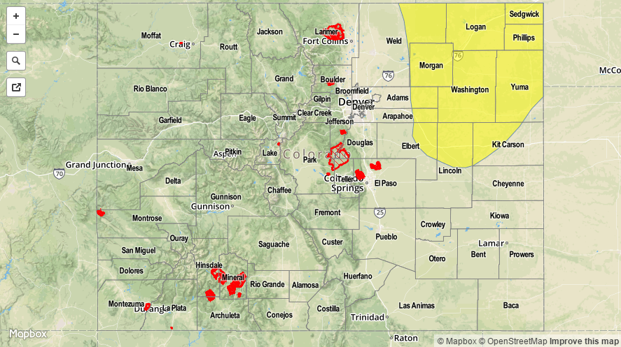

Zone-Specific Forecasts
Urban Corridor, Northeast Plains, Palmer Ridge, Southeast Plains and Raton Ridge:
Isolated-to-widely scattered showers/storms are expected this afternoon and evening, moving to the northeast with the steering flow. Most storms will be garden variety, producing gusty winds and lightning, with periods of light-to-moderate rainfall. A couple storms may become strong/severe over the Palmer Ridge and Northeast Plains, producing bouts with heavy rainfall. For this reason, the low flood threat has been issued. Maximum rain rates will be 0.4-0.8 inches/hour for the Urban Corridor and Raton Ridge, 0.8-1.2 inches/hour for the Southeast Plains, and 1.0-2.0 inches/hour for the Palmer Ridge and Northeast Plains.
Timing: 1 PM – 9 PM for the Urban Corridor and Raton Ridge, 3 PM – 11 PM for the Palmer Ridge, 1 PM – 11 PM for the Southeast Plains, and 3 PM – 1 AM for the Northeast Plains
Front Range, Northern Mountains, Southeast Mountains, Northwest Slope, San Juan Mountains, Southwest Slope, San Luis Valley, Central Mountains, and Grand Valley:
Widely scattered showers/thunderstorms are expected this afternoon/evening. Most will be garden variety, with gusty winds and lightning being the main threats. The best chances for storms will be over the higher terrain of the Southwest Slope, San Juan Mountains, Central Mountains, Northern Mountains, and Front Range. Most rain rates will be 0.2-0.4 inches/hour, with maximum rain rates around 0.4-0.8 inches/hour.
Timing: 11 AM – 9 PM, with a few showers redeveloping over southwestern mountains during the early morning hours tomorrow in association with the next moisture surge