Issue Date: 8/11/2016
Issue Time: 9:58 AM
A LOW FLOOD THREAT HAS BEEN ISSUED FOR PORTIONS OF THE NORTHEAST PLAINS, PALMER RIDGE, AND SOUTHEAST PLAINS.
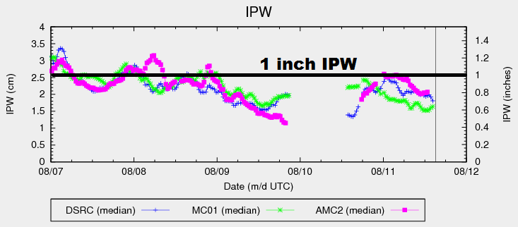
Current water vapor analysis shows the upper-level trough swinging across western states, with the base of the trough over the Great Basin. At the surface, a cool front is draped across the far northeast plains and back across southern Wyoming. This front will swing through eastern Colorado today, providing a focus for the development of scattered showers and thunderstorms. Out west, drier air will be transported in from the west-southwest, keeping IPW values subdued (green line = Grand Junction) and limiting shower/thunderstorm activity. A few isolated showers/storms are still expected over the higher terrain, but will mainly result in gusty winds, lightning, and periods of light-to-moderate rainfall.
Along the I-25 corridor and into the foothills, the atmospheric profile shows the same inverted-V characteristics as yesterday. This will lead any showers/storms in those areas to produce gusty winds, lightning, and light-to-moderate rainfall. Brief heavy downpours will be possible if any storms interact with others outflow boundaries, but this chance is small enough to not warrant any flood threat outlines.
Further east, moisture content is better, with IPW values between 0.9-1.3 inches for much of the eastern Plains per the latest analysis. This amount of moisture will help storms produce efficient rainfall, with storms capable of producing rain at 1.5-2.5 inches/hour. Relatively quick storm motions will help reduce the flood threat. With these considerations in mind, only a low flood threat is warranted. See discussions below for more details on timing and rain rates.
Today’s Flood Threat Map
For more information on today’s flood threat, see the map below (hover over threat areas for more details). For Zone-Specific forecasts, jump below the map.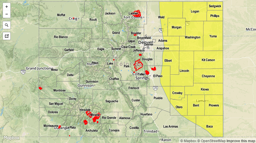

Zone-Specific Forecasts
Urban Corridor, Northeast Plains, Palmer Ridge, Southeast Plains and Raton Ridge:
Scattered showers/storms are expected, with the heaviest rain/strongest storms occurring east of the I-25 corridor. Stronger storms will be capable of producing hail (up to 1.5 inches in diameter), strong winds (gusts up to 60 mph), and locally heavy rainfall. Main flooding concerns will be small streams and normally dry creeks, as well as street/field ponding. Maximum rain rates will be 1.5-2.5 inches/hour for the Palmer Ridge, Northeast Plains, and Southeast Plains, and 0.6-0.8 inches/hour for the Urban Corridor and Raton Ridge.
Timing: Noon – Midnight, with a few storms continuing into the morning hours
Front Range, Northern Mountains, Southeast Mountains, Northwest Slope, San Juan Mountains, Southwest Slope, San Luis Valley, Central Mountains, and Grand Valley:
Isolated-to-widely scattered showers/storms expected, mainly over the higher terrain. The best coverage will occur over the Northern Mountains, Front Range, and Southeast Mountains, with slightly lesser coverage elsewhere. Rain rates will remain below flood threat thresholds, with maximum rates of 0.2-0.4 inches/hour.
Timing: 11 AM – 10 PM, with a few showers/storms continuing over the Front Range and Southeast Mountains until 3 AM.